Category:Souda (island)
Gezinti kısmına atla
Arama kısmına atla
islet near Chania, Crete, Greece  | |||||
| Medya yükle | |||||
| Nedir | |||||
|---|---|---|---|---|---|
| Konumu | Hanya belediyesi, Hanya, Crete Region, Girit Merkezi Olmayan İdaresi, Yunanistan | ||||
| Yanında veya içinde yer aldığı su bölümü | |||||
 | |||||
Alt kategoriler
Bu kategoride, aşağıdaki 2 alt kategori dahil toplam 2 alt kategori vardır.
O
- Old maps of Souda (Crete) (11 F)
S
- Souda Fortress (8 F)
"Souda (island)" kategorisindeki ortam dosyaları
Bu kategoride yer alan toplam 11 dosyanın 11 adedi aşağıdadır.
-
 Boat trip along Kalivon Kefalas Georgopolis - panoramio (16).jpg 4.000 × 3.000; 3,69 MB
-
 Boat trip along Kalivon Kefalas Georgopolis - panoramio (20).jpg 4.000 × 3.000; 3,48 MB
-
 Boat trip along Kalivon Kefalas Georgopolis - panoramio (21).jpg 4.000 × 3.000; 4,14 MB
-
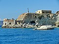
 Cliffs and venetian fortress of Souda.jpg 1.000 × 750; 457 KB
-
 Creta-souda-island-09.jpg 1.600 × 873; 610 KB
-
 Flags Suda.jpg 600 × 800; 71 KB
-
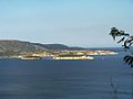 Souda Bay 1.jpg 1.000 × 750; 126 KB
-
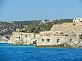
 Souda Bay from the of the Venetian fortress at Souda Island.jpg 1.000 × 750; 425 KB
-
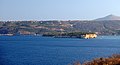
 Souda Island.jpg 2.440 × 1.311; 664 KB
-
 Souda Nisida - panoramio.jpg 2.835 × 1.890; 1,06 MB
-
 Île de Souda (18.IV.14).JPG 4.272 × 2.848; 5,79 MB
.jpg)
.jpg)
.jpg)


.JPG)