Category:St Fagans
Zur Navigation springen
Zur Suche springen
Ortschaft westlich von Cardiff im südlichen Wales  St Mary's Church, St Fagans. .svg) | |||||
| Medium hochladen | |||||
| Ist ein(e) | |||||
|---|---|---|---|---|---|
| Ort | Cardiff, Wales | ||||
 | |||||
Cymraeg: Mae Sain Ffagan yn bentref ar gyrion Caerdydd, prifddinas Cymru. Rhed Afon Elai trwy'r pentref. Yn y castell a'i barcdir ceir Amgueddfa Werin Cymru. Daw'r enw o enw'r sant chwedlonol Ffagan, sy'n ymddangos yng ngwaith Sieffre o Fynwy.
Mae'r Categori yma yn ymwneud â phentref Sain Ffagan yn unig, ac nid Amgueddfa Werin Cymru.
Mae'r Categori yma yn ymwneud â phentref Sain Ffagan yn unig, ac nid Amgueddfa Werin Cymru.
Unterkategorien
Es werden 6 von insgesamt 6 Unterkategorien in dieser Kategorie angezeigt:
In Klammern die Anzahl der enthaltenen Kategorien (K), Seiten (S), Dateien (D)
Medien in der Kategorie „St Fagans“
Folgende 200 Dateien sind in dieser Kategorie, von 224 insgesamt.
(vorherige Seite) (nächste Seite)-
 2010 Wales Cardiff Community St Fagans map.svg 512 × 546; 341 KB
-
 2024 Wales Cardiff Community St Fagans map.svg 512 × 546; 319 KB
-
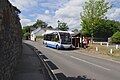 320 Bus at St Fagans.jpg 1.200 × 800; 226 KB
-

-
 A4232 crossing the Cardiff-Swansea railway - geograph.org.uk - 5888194.jpg 1.024 × 775; 125 KB
-
 A4232 east of Sant-y-Nyll - geograph.org.uk - 5888203.jpg 1.024 × 756; 121 KB
-
 A4232 heads south from the M4 - geograph.org.uk - 5249050.jpg 640 × 513; 52 KB
-
 A4232 Link Road - geograph.org.uk - 4833493.jpg 5.472 × 3.648; 7,76 MB
-
 A4232 south of M4 junction 33 - geograph.org.uk - 3126133.jpg 640 × 392; 47 KB
-
 A4232 west of St Fagans - geograph.org.uk - 5888199.jpg 1.024 × 743; 108 KB
-
 Abernodwydd Farmhouse, St Fagans Museum, Cardiff - geograph.org.uk - 5897421.jpg 3.912 × 2.715; 4,25 MB
-
-
 Access road to St Fagans Museum - geograph.org.uk - 3126143.jpg 640 × 426; 38 KB
-

-
 Advance sign for junction 33 of M4 westbound - geograph.org.uk - 5819818.jpg 1.600 × 1.067; 745 KB
-
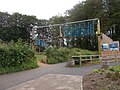 Adventure Playground - St Fagan's Museum - geograph.org.uk - 6199789.jpg 1.024 × 768; 260 KB
-

-
 Battle Field (50682218642).jpg 4.032 × 1.960; 4,13 MB
-
 Beech Avenue (50682147056).jpg 4.032 × 1.960; 3,79 MB
-
 Bridleway sign near Radyr, Cardiff - geograph.org.uk - 4373705.jpg 800 × 762; 161 KB
-

-
 Cardiff , Grassy Field - geograph.org.uk - 6115646.jpg 6.000 × 4.000; 5,33 MB
-
 Cardiff , The A4232 - geograph.org.uk - 6115647.jpg 6.000 × 4.000; 6,48 MB
-
 Cardiff , The A4232 - geograph.org.uk - 6115648.jpg 6.000 × 4.000; 6,55 MB
-
 Cardiff , The A4232 - geograph.org.uk - 6115649.jpg 6.000 × 4.000; 7,47 MB
-
 Cardiff , The A4232 - geograph.org.uk - 6115650.jpg 6.000 × 4.000; 7,47 MB
-
 Cardiff , The A4232 - geograph.org.uk - 6115651.jpg 6.000 × 4.000; 6,71 MB
-
 Cardiff , The M4 Motorway - geograph.org.uk - 3926541.jpg 4.288 × 2.848; 4,92 MB
-
 Cardiff , The M4 Motorway - geograph.org.uk - 3926542.jpg 4.288 × 2.848; 4,22 MB
-
 Cardiff , The M4 Motorway - geograph.org.uk - 3928392.jpg 4.288 × 2.848; 4,95 MB
-
 Cardiff , The M4 Motorway - geograph.org.uk - 3928395.jpg 4.288 × 2.848; 6,11 MB
-
 Cardiff UK community map (St Fagans).svg 1.187 × 1.266; 438 KB
-
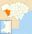
 Cardiff ward location - Creigiau St Fagans.png 800 × 571; 176 KB
-
 Cart shed, St Fagans National History Museum - geograph.org.uk - 5493692.jpg 5.179 × 3.451; 5,42 MB
-

-
 Castle Hill Court, St Fagans - geograph.org.uk - 3910750.jpg 800 × 553; 127 KB
-
 Cilewent Farmhouse, Museum of Welsh Life, St Fagans - geograph.org.uk - 5370958.jpg 4.000 × 3.000; 6,38 MB
-
 Cistern, St Fagans Castle, Cardiff - geograph.org.uk - 5897590.jpg 3.344 × 2.806; 3,93 MB
-
 Civil War battlefield - geograph.org.uk - 6188749.jpg 2.048 × 1.536; 1.019 KB
-
-

-
 Cottages on Castle Hill - geograph.org.uk - 4833698.jpg 5.472 × 3.648; 7,72 MB
-
 Crofft-y-geneau Road looking south - geograph.org.uk - 2223023.jpg 640 × 480; 64 KB
-
 Derelict outbuildings, Michaelston-super-Ely - geograph.org.uk - 2362451.jpg 4.000 × 3.000; 2,86 MB
-
 Derwen Bakehouse - St Fagan's Museum - geograph.org.uk - 6199303.jpg 1.024 × 778; 222 KB
-

-
 Distorted boundary sign, St Fagans - geograph.org.uk - 3886407.jpg 800 × 627; 213 KB
-
 Disused Railway Bridge - geograph.org.uk - 4833507.jpg 5.472 × 3.648; 6,28 MB
-

-
 Disused Railway Embankment - geograph.org.uk - 4833599.jpg 5.472 × 3.648; 6,41 MB
-
 Driveway to Slanwood Boarding Kennels - geograph.org.uk - 2082019.jpg 2.816 × 2.112; 1,82 MB
-
 Driveway to Tregyrnog - geograph.org.uk - 4833500.jpg 5.472 × 3.648; 7,05 MB
-
 Duke of Gloucester near St. Fagans - geograph.org.uk - 1923756.jpg 640 × 480; 92 KB
-
 Dutch garden, St Fagans Castle - geograph.org.uk - 5936859.jpg 5.179 × 3.451; 5,73 MB
-
 East along the Ely Trail, St Fagans - geograph.org.uk - 3910737.jpg 800 × 703; 179 KB
-
 East Gate, St Fagans Castle, Cardiff - geograph.org.uk - 5897599.jpg 3.103 × 2.595; 2,63 MB
-
 Eastern boundary of St Fagans - geograph.org.uk - 3787516.jpg 800 × 613; 153 KB
-
 Ely downstream from St Fagans Bridge - geograph.org.uk - 3911719.jpg 800 × 600; 213 KB
-
 Ely River - geograph.org.uk - 4833695.jpg 5.472 × 3.648; 7,79 MB
-
 Ely Trail St Fagans.JPG 2.058 × 1.452; 1,01 MB
-
 Ely Trail, Cardiff - geograph.org.uk - 1923760.jpg 640 × 480; 70 KB
-
 Ely Trail, St Fagans, Cardiff.jpg 1.000 × 750; 236 KB
-
 Ely upstream from St Fagans Bridge - geograph.org.uk - 3911706.jpg 800 × 600; 169 KB
-
 End of the 40 zone near Radyr, Cardiff - geograph.org.uk - 4373808.jpg 800 × 591; 123 KB
-
 Entering Cardiff at junction 33 on the M4 - geograph.org.uk - 4321726.jpg 1.600 × 1.200; 1,06 MB
-
 Entrance to Penhefyd Farm, St Fagans - geograph.org.uk - 3886411.jpg 798 × 800; 267 KB
-
 Farm track across two bridges - geograph.org.uk - 4145502.jpg 4.000 × 3.000; 4,82 MB
-
 Farmland, St Fagans, Cardiff - geograph.org.uk - 4591623.jpg 800 × 612; 142 KB
-

-
 Fields on the edge of Pentrebane, Cardiff - geograph.org.uk - 2084968.jpg 2.816 × 2.112; 1,62 MB
-

-
 Fish Rearing Pool, St Fagans Museum, Cardiff - geograph.org.uk - 5897492.jpg 2.846 × 1.817; 1,28 MB
-
 Footbridge, Gweithdy, St Fagans National History Museum - geograph.org.uk - 5491655.jpg 5.184 × 3.456; 5,36 MB
-
 Footpath near St. Fagans - geograph.org.uk - 2082024.jpg 2.112 × 2.816; 2,72 MB
-
 Footpath, Michaelston-super-Ely - geograph.org.uk - 2362478.jpg 4.000 × 3.000; 3,96 MB
-
 Forecourt, St Fagans Museum, Cardiff - geograph.org.uk - 5897610.jpg 3.787 × 2.985; 3,48 MB
-

-
 Former railway bridge on A4119 - geograph.org.uk - 2081997.jpg 2.816 × 2.112; 2,48 MB
-

-

-

-
 Gateway and track to Stockland Farm - geograph.org.uk - 1516427.jpg 640 × 480; 79 KB
-
 Gorse Mill, St Fagans National History Museum - geograph.org.uk - 5689445.jpg 1.024 × 768; 1,41 MB
-
 Grade II listed Hill Cottage, St Fagans - geograph.org.uk - 3910679.jpg 800 × 521; 129 KB
-

-

-
 Greenhouses St Fagans - geograph.org.uk - 4854420.jpg 640 × 428; 107 KB
-
 Gwalia Stores and Photographer's Shop, St. Fagans - geograph.org.uk - 5269944.jpg 1.600 × 1.200; 414 KB
-
 Gweithdy, St Fagans National History Museum - geograph.org.uk - 5689397.jpg 1.024 × 768; 1,03 MB
-
 GWR Swansea to Cardiff line - geograph.org.uk - 4835020.jpg 3.648 × 5.472; 6,68 MB
-
 Hayshed, St Fagans National History Museum - geograph.org.uk - 5693527.jpg 1.024 × 768; 1,14 MB
-
 Hendre-wen barn (2), St Fagans N H Museum - geograph.org.uk - 5936736.jpg 5.184 × 3.456; 5,17 MB
-
 Hendre-wen barn, St Fagans National History Museum - geograph.org.uk - 5936722.jpg 5.184 × 3.456; 5,85 MB
-

-
 Inside Maestir School at St Fagan's Museum - geograph.org.uk - 6199292.jpg 1.024 × 825; 128 KB
-

-
 Kennixton Farmhouse, St Fagans Museum, Cardiff - geograph.org.uk - 5897458.jpg 2.616 × 2.394; 1,94 MB
-
 Kiln, St Fagans National History Museum - geograph.org.uk - 5936396.jpg 5.179 × 3.451; 4,7 MB
-

-

-
 Level crossing warning sign, St Fagans - geograph.org.uk - 3910709.jpg 800 × 718; 156 KB
-

-

-

-
 M4 approaching J33 - geograph.org.uk - 3683067.jpg 640 × 430; 39 KB
-
 M4 at Junction 33 - geograph.org.uk - 3683069.jpg 640 × 430; 37 KB
-
 M4 at Junction 33 - geograph.org.uk - 4138284.jpg 800 × 493; 53 KB
-
 M4 eastbound at Junction 33 - geograph.org.uk - 3274069.jpg 640 × 481; 46 KB
-
 M4 eastbound at junction 33 - geograph.org.uk - 4321736.jpg 1.600 × 1.200; 1.018 KB
-
 M4 eastbound towards junction 32 - geograph.org.uk - 4321773.jpg 1.600 × 1.221; 904 KB
-
 M4 Motorway Junction 33 - geograph.org.uk - 2455861.jpg 640 × 480; 85 KB
-
 M4 near Jct 33 - geograph.org.uk - 2441641.jpg 2.816 × 2.112; 1,78 MB
-
 M4 passes under Llantrisant Road - geograph.org.uk - 3274076.jpg 640 × 480; 47 KB
-
 M4, J33 overbridges - geograph.org.uk - 3683070.jpg 640 × 430; 33 KB
-
 M4, westbound - geograph.org.uk - 3683059.jpg 640 × 430; 42 KB
-
 M4, westbound - geograph.org.uk - 3683064.jpg 640 × 430; 39 KB
-
-
 Maes-y-llech Farm near Radyr, Cardiff - geograph.org.uk - 4373852.jpg 800 × 574; 123 KB
-
 Medieval House, St Fagans Museum, Cardiff - geograph.org.uk - 5896862.jpg 4.012 × 3.009; 3,16 MB
-
 Mews, St Fagans Castle, Cardiff - geograph.org.uk - 5897614.jpg 3.963 × 2.972; 2,81 MB
-

-
 Miners' Institute, St Fagans Museum, Cardiff - geograph.org.uk - 5896607.jpg 3.567 × 2.765; 3,16 MB
-
 Miners' Institute, St Fagans Museum, Cardiff - geograph.org.uk - 5896633.jpg 3.776 × 3.024; 1,99 MB
-
 Miners' Institute, St Fagans Museum, Cardiff - geograph.org.uk - 5896689.jpg 3.369 × 2.907; 1,71 MB
-
 Minor Road - geograph.org.uk - 5411254.jpg 3.264 × 2.448; 1,28 MB
-
 Minor road to Radyr, Cardiff - geograph.org.uk - 4373819.jpg 800 × 504; 102 KB
-
 Missing railway bridge near St. Fagans - geograph.org.uk - 2082029.jpg 2.816 × 2.112; 2,3 MB
-
 Nant Y Drope, Cardiff - geograph.org.uk - 2162579.jpg 640 × 480; 69 KB
-
 Nantwallter Cottage, St Fagans Museum, Cardiff - geograph.org.uk - 5897410.jpg 3.885 × 2.913; 4,37 MB
-

-
 North across St Fagans Bridge, St Fagans - geograph.org.uk - 3911685.jpg 800 × 581; 194 KB
-
 North West of St Fagans National History Museum - geograph.org.uk - 4605101.jpg 3.072 × 2.304; 1,95 MB
-

-

-
 Ordnance Survey Cut Mark - geograph.org.uk - 5947750.jpg 787 × 1.024; 171 KB
-
 Ordnance Survey Cut Mark - geograph.org.uk - 5947754.jpg 1.024 × 682; 282 KB
-
 Ordnance Survey Flush Bracket (G3713) - geograph.org.uk - 5947759.jpg 936 × 1.024; 218 KB
-
 Ordnance Survey Flush Bracket (S9120) - geograph.org.uk - 6308248.jpg 807 × 1.024; 271 KB
-
 Path to Plymouth Great Wood, Cardiff - geograph.org.uk - 3911016.jpg 800 × 600; 190 KB
-

-

-
 Pentrebane Road - geograph.org.uk - 4833677.jpg 5.472 × 3.648; 5,02 MB
-
 Persondy Lane, Michaelston-super-Ely - geograph.org.uk - 2362491.jpg 4.000 × 3.000; 2,9 MB
-
 Pigsty, St Fagans National Museum, Cardiff - geograph.org.uk - 5896540.jpg 2.822 × 2.850; 2,2 MB
-
 Police layby on the M4 eastbound, east of junction 33 - geograph.org.uk - 4321771.jpg 1.600 × 1.200; 1,1 MB
-
 Prefab house, St Fagans Museum, Cardiff - geograph.org.uk - 5896735.jpg 3.517 × 2.126; 2,27 MB
-

-
 Rail over Rail - geograph.org.uk - 2581658.jpg 2.560 × 1.920; 963 KB
-
 Rear of Gwalia Stores, St Fagans National History Museum - geograph.org.uk - 5490687.jpg 5.184 × 3.456; 4,99 MB
-
 Rebuilding The Vulcan Hotel - geograph.org.uk - 6233281.jpg 5.048 × 3.366; 4,8 MB
-
 Reconstructed boundary wall, Llys Llwelyn - geograph.org.uk - 6233163.jpg 5.179 × 3.451; 5,22 MB
-
 River Ely at St. Fagan's - geograph.org.uk - 1951390.jpg 480 × 640; 101 KB
-
 Riverside Cottage, St Fagans - geograph.org.uk - 3910771.jpg 679 × 800; 203 KB
-
 Road bridge on A4119 - geograph.org.uk - 5943882.jpg 2.448 × 3.264; 3,06 MB
-
 Road bridge over Barry Railway - geograph.org.uk - 1935040.jpg 3.648 × 2.736; 4,17 MB
-
 Road bridge over Taff Vale Railway - geograph.org.uk - 2581633.jpg 2.560 × 1.920; 861 KB
-
 Road north from St Fagans - geograph.org.uk - 3886409.jpg 800 × 645; 166 KB
-

-
 Roadworks on the A4119 - geograph.org.uk - 5755886.jpg 3.264 × 2.448; 2,98 MB
-
 Rosery, St Fagans Castle - geograph.org.uk - 5936873.jpg 5.048 × 3.366; 5,3 MB
-
 Roundabout and Housing - geograph.org.uk - 5411276.jpg 2.907 × 2.180; 1,47 MB
-
 Route Map (50681377728).jpg 4.752 × 3.168; 5,66 MB
-
 Route of dismantled railway west of Cardiff - geograph.org.uk - 2082014.jpg 2.112 × 2.816; 2,5 MB
-
 Row of 3 cottages, St Fagans - geograph.org.uk - 3886438.jpg 800 × 529; 126 KB
-

-

-
 Sain Ffagan - St Fagans - geograph.org.uk - 4388311.jpg 640 × 480; 99 KB
-
 Site of Battle of St.Fagans - geograph.org.uk - 4833514.jpg 5.472 × 3.648; 4,66 MB
-
 Site of the Battle of St Fagans - geograph.org.uk - 2395992.jpg 640 × 480; 78 KB
-
-
 Slip road from M4 J33 onto A4232 southbound - geograph.org.uk - 5819824.jpg 1.600 × 961; 526 KB
-
-
 St Fagan's Castle (4785956).jpg 1.157 × 678; 206 KB
-
 St Fagans and around, August 2019 12.jpg 4.032 × 3.024; 3,07 MB
-
 St Fagans Castle, St Fagans Museum, Cardiff - geograph.org.uk - 5897563.jpg 3.621 × 2.795; 2,04 MB
-
 St Fagans Cricket ^ Bowls Club - geograph.org.uk - 3886410.jpg 800 × 511; 144 KB
-
 St Fagans Drive, St Fagans - geograph.org.uk - 3886417.jpg 800 × 600; 179 KB
-
 St Fagans Ground Frame - geograph.org.uk - 3911118.jpg 800 × 546; 147 KB
-
 St Fagans in Autumn - geograph.org.uk - 1671424.jpg 1.200 × 1.600; 826 KB
-
 St Fagans Village (50682211157).jpg 4.752 × 3.168; 12,57 MB
-
 St Fagans village entrance sign - geograph.org.uk - 2223036.jpg 640 × 480; 85 KB
-
 St Fagans Village Hall - geograph.org.uk - 3886412.jpg 800 × 601; 150 KB
-
 St Fagans Village Hall.jpg 3.911 × 2.773; 3,1 MB
-
 St Fagans, Cardiff CF5, UK - panoramio (7).jpg 4.000 × 3.000; 6,89 MB
-
 St Mary's Church, St Fagans - geograph.org.uk - 5936888.jpg 5.243 × 3.545; 4,25 MB
-

-
 St Teilo's Church, St Fagans National History Museum - geograph.org.uk - 5693543.jpg 1.024 × 768; 1,04 MB
-
 St. Fagans Court, May 2020.jpg 4.032 × 3.024; 3 MB
-
 St.Fagans Level Crossing - geograph.org.uk - 4835002.jpg 3.648 × 5.472; 6,29 MB
-
-

-

-
 Stile to footpath, St Bride's Rd - geograph.org.uk - 1516448.jpg 640 × 480; 145 KB
-
 Stile to footpath, St Bride's Rd - geograph.org.uk - 1516451.jpg 640 × 480; 146 KB
-
 Stile to footpath, St Bride's Rd - geograph.org.uk - 1516463.jpg 640 × 480; 90 KB
-
 Stone stile, St Michael's churchyard, Michaelston-super-Ely - geograph.org.uk - 2362424.jpg 4.000 × 3.000; 2,95 MB
-
 Stryd Lydan Barn, St Fagans Museum, Cardiff. - geograph.org.uk - 5897484.jpg 3.812 × 2.859; 3,57 MB
-
 Summer House, St Fagans Museum, Cardiff - geograph.org.uk - 5897507.jpg 3.873 × 2.744; 2,92 MB
-
 Thatched cottages in St Fagans - geograph.org.uk - 3910697.jpg 800 × 639; 182 KB
-
 The Old Post House - geograph.org.uk - 4833689.jpg 5.472 × 3.648; 4,43 MB


.jpg)
.jpg)


,_St_Fagans_N_H_Museum_-_geograph.org.uk_-_5936736.jpg)


_-_geograph.org.uk_-_5947759.jpg)
_-_geograph.org.uk_-_6308248.jpg)


.jpg)


.jpg)


.jpg)


.jpg)


