Category:Stabius world map
Zur Navigation springen
Zur Suche springen
Holzschnitt von Albrecht Dürer  | |||||
| Medium hochladen | |||||
| Ist ein(e) | |||||
|---|---|---|---|---|---|
| Urheber | |||||
| Besteht aus |
| ||||
| Sammlung | |||||
| Inventarnummer |
| ||||
| Datum der Gründung, Erstellung, Entstehung, Erbauung |
| ||||
| |||||
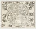
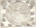
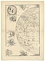
The Stabius World Map, in German Stabiussche Weltkarte, is thought to be the the first perspective view of the terrestrial globe to have been published. It was made by Durer in 1515.
Unterkategorien
Es werden 2 von insgesamt 2 Unterkategorien in dieser Kategorie angezeigt:
In Klammern die Anzahl der enthaltenen Kategorien (K), Seiten (S), Dateien (D)
D
- Dürer (Kurth 297) (2 D)
- Dürer (Kurth 298) (2 D)
Medien in der Kategorie „Stabius world map“
Folgende 11 Dateien sind in dieser Kategorie, von 11 insgesamt.
-
 Stabius world map II.jpg 1.400 × 1.106; 1,32 MB
-
 Stabius world map.jpg 1.700 × 1.296; 531 KB
-
 Stabius world map silhouette.png 3.372 × 2.540; 20,13 MB
-
 Stabius map of the world II.jpg 2.191 × 1.646; 2,62 MB
-
 Stabius map of the world.jpg 750 × 596; 156 KB
-
 Stabius-Durer world map.jpg 2.834 × 2.084; 835 KB
-
 Durer Stabiussche Weltkarte 1515.jpg 4.223 × 3.306; 1,69 MB
-
 Durer Stabiussche Weltkarte World Map 1515.jpg 4.902 × 3.780; 2,32 MB
-
 Print, map (BM 1848,1111.7-8).jpg 2.500 × 1.989; 1,11 MB
-
-


.jpg)
_de_Jean_Stabius,_1515_(Reproduction_en_fac-simil%C3%A9)_-_btv1b53025194f_(1_of_2).jpg)
_de_Jean_Stabius,_1515_(Reproduction_en_fac-simil%C3%A9)_-_btv1b53025194f_(2_of_2).jpg)