Category:Staunton Coleford
Vai alla navigazione
Vai alla ricerca
village in Staunton Coleford, Forest of Dean, Gloucestershire, UK  | |||||
| Carica un file multimediale | |||||
| Istanza di | |||||
|---|---|---|---|---|---|
| Luogo | Staunton Coleford, Forest of Dean, Gloucestershire, Sud Ovest dell'Inghilterra, Inghilterra | ||||
 | |||||
Sottocategorie
Questa categoria contiene le 3 sottocategorie indicate di seguito, su un totale di 3.
File nella categoria "Staunton Coleford"
Questa categoria contiene 200 file, indicati di seguito, su un totale di 231.
(pagina precedente) (pagina successiva)-
 A4136 approaching Staunton - geograph.org.uk - 1441524.jpg 640 × 480; 254 KB
-
 A4136 leaves Staunton for Monmouth - geograph.org.uk - 617830.jpg 640 × 418; 135 KB
-
 A4136 passing through Staunton - geograph.org.uk - 617827.jpg 640 × 480; 134 KB
-
 A4136, Staunton - geograph.org.uk - 5506340.jpg 640 × 427; 49 KB
-
 Accident Repair Centre, Staunton - geograph.org.uk - 2729500.jpg 640 × 376; 45 KB
-
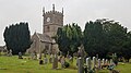
 All Saints Church, Staunton - geograph.org.uk - 5422356.jpg 1 600 × 1 200; 410 KB
-
 All Saints Church, Staunton - geograph.org.uk - 5506343.jpg 1 024 × 683; 338 KB
-
 All Saints Church, Staunton - geograph.org.uk - 5692148.jpg 640 × 480; 68 KB
-
 All Saints Churtch, Staunton - geograph.org.uk - 5692151.jpg 640 × 591; 76 KB
-
 All Saints' church, Staunton - geograph.org.uk - 6057998.jpg 1 024 × 768; 196 KB
-
 All Saints' church, Staunton - geograph.org.uk - 6228207.jpg 4 032 × 2 268; 1,55 MB
-
 All Saints' church, tomb by the south porch - geograph.org.uk - 6058014.jpg 1 024 × 768; 304 KB
-
 All Saints' church. interior, looking east - geograph.org.uk - 6058010.jpg 1 024 × 768; 146 KB
-

-
 All Saints, Staunton - geograph.org.uk - 3267671.jpg 800 × 556; 105 KB
-
 All Saints, Staunton - geograph.org.uk - 3267672.jpg 1 600 × 1 066; 379 KB
-
 All Saints, Staunton - geograph.org.uk - 4512836.jpg 640 × 480; 77 KB
-
 All Saints, Staunton, Gloucestershire - geograph.org.uk - 3267670.jpg 1 600 × 1 414; 463 KB
-
 Approaching Newland - geograph.org.uk - 4683961.jpg 1 600 × 946; 300 KB
-
 Arable field near Newland - geograph.org.uk - 3665292.jpg 1 024 × 680; 300 KB
-
 Autumn colours in the Forest of Dean - geograph.org.uk - 5967325.jpg 1 024 × 768; 385 KB
-
 Belmont in Staunton (Coleford) - geograph.org.uk - 3769893.jpg 1 600 × 1 126; 447 KB
-
 Belmont in Staunton (Coleford) - geograph.org.uk - 3769895.jpg 1 600 × 1 098; 491 KB
-
 Blake's Wood - geograph.org.uk - 5506329.jpg 1 024 × 683; 331 KB
-
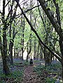
 Bluebells - geograph.org.uk - 2167019.jpg 1 200 × 1 600; 709 KB
-
 Bluebells and a Dog - geograph.org.uk - 5616412.jpg 1 206 × 1 600; 633 KB
-
 Bracelands Campsite - geograph.org.uk - 2151757.jpg 1 195 × 1 649; 427 KB
-
 Brindsey's Well - geograph.org.uk - 1725949.jpg 640 × 480; 119 KB
-
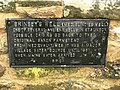 Brindsey's Well - geograph.org.uk - 1725966.jpg 640 × 480; 132 KB
-
 Buck Stone - geograph.org.uk - 2156515.jpg 1 600 × 1 071; 508 KB
-
 Buck Stone - geograph.org.uk - 3307718.jpg 1 600 × 1 200; 1,55 MB
-
 Buck Stone - geograph.org.uk - 3308740.jpg 1 600 × 1 200; 1,55 MB
-
 Buck Stone, Triangulation pillar - geograph.org.uk - 854806.jpg 640 × 480; 87 KB
-
 Bunjups Wood - geograph.org.uk - 1725866.jpg 480 × 640; 143 KB
-
 Byway to the south of Staunton - geograph.org.uk - 3665218.jpg 1 024 × 680; 259 KB
-
 Camping ^ caravan site near Newland - geograph.org.uk - 4493120.jpg 800 × 481; 110 KB
-
 Cast With Character, Staunton - geograph.org.uk - 2729510.jpg 640 × 459; 70 KB
-
 Cherry Orchard Cottage, Newland - geograph.org.uk - 4498410.jpg 800 × 615; 122 KB
-
 Cherry Orchard Farm near Newland - geograph.org.uk - 4493022.jpg 800 × 465; 104 KB
-
 Church Cottage, Staunton - geograph.org.uk - 2729820.jpg 640 × 619; 81 KB
-
 Church cross, Staunton - geograph.org.uk - 745758.jpg 479 × 639; 228 KB
-
 Churchyard and farm, Staunton - geograph.org.uk - 5903710.jpg 1 024 × 768; 182 KB
-
 Clearing, Patches Wood - geograph.org.uk - 5510745.jpg 1 024 × 683; 433 KB
-

-
 Country road near Newland - geograph.org.uk - 3665302.jpg 1 024 × 680; 222 KB
-

-
 Deer Lurking - geograph.org.uk - 2167082.jpg 892 × 452; 56 KB
-
 Double View - geograph.org.uk - 2159265.jpg 1 024 × 679; 186 KB
-

-
-

-
 Farmland near Staunton - geograph.org.uk - 3665245.jpg 1 024 × 680; 177 KB
-
 Fields - geograph.org.uk - 4267860.jpg 640 × 480; 65 KB
-
 Footpath beside the road - geograph.org.uk - 3335478.jpg 640 × 480; 100 KB
-
 Grazing land south of Staunton - geograph.org.uk - 2156709.jpg 1 024 × 768; 298 KB
-
 High Meadow Farm - geograph.org.uk - 3183083.jpg 1 024 × 680; 227 KB
-
 House on the western edge of Staunton - geograph.org.uk - 3427199.jpg 1 024 × 768; 127 KB
-
 Houses in Staunton village - geograph.org.uk - 617873.jpg 640 × 480; 152 KB
-
 In Knockalls Inclosure - geograph.org.uk - 1725873.jpg 640 × 480; 160 KB
-
 Knockalls Enclosure - geograph.org.uk - 2171874.jpg 1 024 × 679; 113 KB
-
 Knockalls Inclosure - geograph.org.uk - 5506316.jpg 1 024 × 683; 477 KB
-
 Lane in Staunton - geograph.org.uk - 1725935.jpg 640 × 471; 94 KB
-
 Lane north to Staunton - geograph.org.uk - 1439653.jpg 640 × 480; 257 KB
-
 Lane south from Staunton - geograph.org.uk - 1439668.jpg 640 × 480; 237 KB
-
 Lane south from Staunton - geograph.org.uk - 1439678.jpg 640 × 480; 251 KB
-
 Lane south of Staunton - geograph.org.uk - 2156705.jpg 1 024 × 768; 322 KB
-
 Lane through Birchen Wood - geograph.org.uk - 2156745.jpg 1 024 × 768; 438 KB
-
 Lane to Staunton - geograph.org.uk - 2156699.jpg 1 024 × 784; 295 KB
-

-

-

-
 Marian's Enclosure, from a lay-by by the A4136 - geograph.org.uk - 3427204.jpg 1 024 × 767; 223 KB
-
 Meadow at Staunton - geograph.org.uk - 3766731.jpg 1 600 × 1 071; 247 KB
-
 Meadow south of Staunton - geograph.org.uk - 2156692.jpg 1 024 × 768; 345 KB
-
 Nave of All Saints' church, Staunton - geograph.org.uk - 6228208.jpg 4 032 × 2 268; 2,15 MB
-
 Near The Scowles - geograph.org.uk - 2169819.jpg 1 024 × 679; 163 KB
-
 New houses, Staunton - geograph.org.uk - 5506342.jpg 1 024 × 683; 267 KB
-

-

-

-
 Old property in Staunton - geograph.org.uk - 3122500.jpg 640 × 480; 78 KB
-
 Ordnance Survey Cut Mark - geograph.org.uk - 5209172.jpg 3 903 × 2 927; 3,37 MB
-
 Overhead power lines, Upper Redbrook - geograph.org.uk - 4492332.jpg 600 × 800; 165 KB
-
 Overlooking Upper Redbrook - geograph.org.uk - 2165818.jpg 1 024 × 768; 415 KB
-
 Pasture west of Blake's Wood - geograph.org.uk - 1439683.jpg 640 × 480; 230 KB
-
 Patches Wood - geograph.org.uk - 3261149.jpg 1 280 × 1 186; 397 KB
-
 Patches Woods - Forest Track - geograph.org.uk - 3261138.jpg 1 024 × 768; 346 KB
-
 Path and Triangulation Pillar at Buck Stone - geograph.org.uk - 5209162.jpg 4 000 × 3 000; 4,98 MB
-
 Path at Staunton - geograph.org.uk - 1725972.jpg 480 × 640; 127 KB
-
 Path between Staunton and the Buck Stone - geograph.org.uk - 3124078.jpg 640 × 480; 150 KB
-
 Path by Knockalls Lodge - geograph.org.uk - 5506320.jpg 1 024 × 683; 461 KB
-
 Path in Blake's Wood - geograph.org.uk - 1726001.jpg 640 × 480; 160 KB
-
 Path in Bunjups Wood - geograph.org.uk - 3335527.jpg 640 × 480; 137 KB
-
 Path into Highmeadow Woods - geograph.org.uk - 6228212.jpg 4 032 × 2 268; 3,83 MB
-
 Path junction near Staunton - geograph.org.uk - 3122553.jpg 640 × 480; 119 KB
-
 Path junction, Whippington Brook valley - geograph.org.uk - 1724296.jpg 640 × 480; 115 KB
-
 Path, Knockalls Inclosure - geograph.org.uk - 5506306.jpg 1 024 × 683; 502 KB
-
 Path, Patches Wood - geograph.org.uk - 5506359.jpg 1 024 × 683; 417 KB
-
 Pawprint in the mud in Bunjups Wood - geograph.org.uk - 3335554.jpg 640 × 480; 121 KB
-
 Preaching Cross, Staunton - geograph.org.uk - 5692155.jpg 640 × 480; 117 KB
-
 Public footpath near Upper Redbrook - geograph.org.uk - 4492921.jpg 800 × 600; 142 KB
-

-
 Redbrook - geograph.org.uk - 2171752.jpg 1 600 × 1 071; 249 KB
-
 Redding's Inclosure - geograph.org.uk - 5506350.jpg 1 024 × 683; 513 KB
-
 Reddings Enclosure - geograph.org.uk - 2151751.jpg 3 872 × 2 592; 1,48 MB
-
 Reddings Lodge - geograph.org.uk - 2151646.jpg 1 600 × 1 081; 751 KB
-
 Remains of church cross, Staunton - geograph.org.uk - 617879.jpg 640 × 480; 183 KB
-
 Remains of the village cross, Staunton - geograph.org.uk - 1876480.jpg 3 296 × 2 472; 1,79 MB
-
 Restricted byway, Staunton - geograph.org.uk - 617867.jpg 640 × 467; 138 KB
-
 Ride in Blake's Wood - geograph.org.uk - 1726043.jpg 482 × 640; 82 KB
-
 Road - geograph.org.uk - 4267857.jpg 640 × 480; 67 KB
-
 Road - geograph.org.uk - 4267863.jpg 640 × 480; 86 KB
-
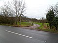
 Road closed - geograph.org.uk - 3665262.jpg 1 024 × 680; 211 KB
-

-
 Road from Staunton to Coleford - geograph.org.uk - 2729821.jpg 640 × 541; 69 KB
-
 Road junction - geograph.org.uk - 3665275.jpg 1 024 × 680; 270 KB
-

-
 Road to Redding's Lodge - geograph.org.uk - 5506354.jpg 1 024 × 683; 420 KB
-
 Road to Staunton Meend from Staunton - geograph.org.uk - 2729524.jpg 640 × 469; 66 KB
-

-
 Rodge Wood from Wyastone Leys - geograph.org.uk - 3767741.jpg 1 600 × 1 200; 360 KB
-

-

-
 Stanton Church and The Elms - geograph.org.uk - 2151785.jpg 1 600 × 900; 376 KB
-
 Staunton (Coleford) - geograph.org.uk - 3764661.jpg 1 600 × 1 070; 283 KB
-
 Staunton - geograph.org.uk - 1725943.jpg 640 × 396; 71 KB
-
 Staunton - geograph.org.uk - 2140845.jpg 640 × 360; 118 KB
-
 Staunton - geograph.org.uk - 2151770.jpg 3 872 × 2 592; 1,1 MB
-
 Staunton - geograph.org.uk - 2153054.jpg 1 024 × 679; 181 KB
-
 Staunton - geograph.org.uk - 2153055.jpg 1 024 × 647; 203 KB
-
 Staunton - geograph.org.uk - 2153059.jpg 1 024 × 679; 186 KB
-
 Staunton - geograph.org.uk - 2153066.jpg 1 024 × 679; 270 KB
-
 Staunton - geograph.org.uk - 2153069.jpg 1 024 × 679; 235 KB
-
 Staunton - geograph.org.uk - 2153074.jpg 1 024 × 679; 268 KB
-
 Staunton - geograph.org.uk - 2153076.jpg 1 024 × 679; 228 KB
-
 Staunton - geograph.org.uk - 2153078.jpg 679 × 1 024; 185 KB
-
 Staunton - geograph.org.uk - 2153080.jpg 1 024 × 679; 234 KB
-
 Staunton - geograph.org.uk - 2154815.jpg 679 × 1 024; 336 KB
-
 Staunton - geograph.org.uk - 2154817.jpg 1 024 × 679; 198 KB
-
 Staunton - geograph.org.uk - 2154822.jpg 1 024 × 679; 167 KB
-
 Staunton - geograph.org.uk - 2154824.jpg 1 024 × 679; 191 KB
-
 Staunton - geograph.org.uk - 2155145.jpg 2 272 × 1 704; 2,22 MB
-
 Staunton - geograph.org.uk - 2155155.jpg 2 272 × 1 704; 2,33 MB
-
 Staunton - geograph.org.uk - 2155278.jpg 3 872 × 2 592; 6,62 MB
-
 Staunton - geograph.org.uk - 2159190.jpg 1 272 × 1 600; 370 KB
-
 Staunton - geograph.org.uk - 2159207.jpg 1 024 × 679; 198 KB
-
 Staunton - geograph.org.uk - 2159216.jpg 1 024 × 679; 205 KB
-
 Staunton - geograph.org.uk - 2159270.jpg 1 024 × 679; 204 KB
-
 Staunton - geograph.org.uk - 2159453.jpg 1 024 × 679; 181 KB
-
 Staunton - geograph.org.uk - 2159460.jpg 1 600 × 1 071; 319 KB
-
 Staunton - geograph.org.uk - 3236055.jpg 1 963 × 1 376; 2,11 MB
-
 Staunton - New Build - geograph.org.uk - 5613446.jpg 1 280 × 857; 249 KB
-
 Staunton Bends - geograph.org.uk - 2165929.jpg 1 600 × 1 081; 664 KB
-
 Staunton Church - geograph.org.uk - 3309660.jpg 1 024 × 694; 175 KB
-
 Staunton Church - geograph.org.uk - 3309670.jpg 853 × 1 280; 152 KB
-
 Staunton church - geograph.org.uk - 3670276.jpg 1 024 × 680; 191 KB
-
 Staunton Helicopter Visit - geograph.org.uk - 2151828.jpg 1 376 × 946; 694 KB
-
 Staunton Helicopter Visit - geograph.org.uk - 2151831.jpg 1 368 × 738; 330 KB
-
 Staunton Long Stone - geograph.org.uk - 1087101.jpg 431 × 640; 107 KB
-
 Staunton Meend - geograph.org.uk - 2171868.jpg 1 600 × 1 071; 427 KB
-
 Staunton Meend - geograph.org.uk - 5506323.jpg 1 024 × 683; 434 KB
-
 Staunton Open Fields - geograph.org.uk - 2174070.jpg 1 024 × 685; 218 KB
-
 Staunton Post Office - geograph.org.uk - 2151769.jpg 640 × 439; 57 KB
-

-

-
 Staunton Village - geograph.org.uk - 2151765.jpg 2 158 × 1 399; 448 KB
-
 Staunton Village - geograph.org.uk - 286655.jpg 640 × 480; 39 KB
-
 Staunton Village Hall - geograph.org.uk - 2142581.jpg 640 × 424; 61 KB
-
 Staunton village hall - geograph.org.uk - 2156632.jpg 1 024 × 768; 258 KB
-
 Staunton, Long Stone - geograph.org.uk - 5947995.jpg 1 024 × 768; 307 KB
-
 Staunton, White Horse - geograph.org.uk - 5947982.jpg 1 024 × 749; 120 KB
-
 Stone adjacent to the Buck Stone - geograph.org.uk - 3124123.jpg 640 × 480; 117 KB
-
 Stowfield Quarry - geograph.org.uk - 2151457.jpg 640 × 428; 59 KB
-
 Stowfield Quarry - geograph.org.uk - 2151458.jpg 3 872 × 2 592; 1,09 MB
-
 Stowfield Quarry - geograph.org.uk - 2171744.jpg 1 200 × 1 600; 349 KB
-
 Swanpool Wood - geograph.org.uk - 5506303.jpg 1 024 × 683; 311 KB
-
 The A4316 road to Staunton - geograph.org.uk - 5692145.jpg 640 × 430; 104 KB
-
 The Buck Stone - geograph.org.uk - 3124112.jpg 640 × 480; 142 KB
-
 The Buck Stone - geograph.org.uk - 736918.jpg 640 × 426; 92 KB
-
 The church and cross in Staunton - geograph.org.uk - 3122541.jpg 640 × 480; 104 KB
-
 The Elms - 1 - geograph.org.uk - 2165928.jpg 1 024 × 768; 330 KB
-
 The Kymin - geograph.org.uk - 2156534.jpg 1 600 × 992; 487 KB
-
 The Long Stone near Staunton - geograph.org.uk - 3122611.jpg 640 × 480; 147 KB
-
 The old cross and Church at Staunton - geograph.org.uk - 2349638.jpg 640 × 480; 111 KB
-
 The Old Station, Newland - geograph.org.uk - 4498445.jpg 800 × 768; 174 KB
-
 The old village pound at Staunton - geograph.org.uk - 3122522.jpg 640 × 480; 116 KB
-
 The Pound at Staunton - geograph.org.uk - 2155670.jpg 1 024 × 768; 329 KB
-
 The pound in Staunton - geograph.org.uk - 3670288.jpg 1 024 × 680; 281 KB
-
 The road down to Staunton - geograph.org.uk - 5692156.jpg 640 × 480; 77 KB
-
 The Steps in Staunton - geograph.org.uk - 3122490.jpg 640 × 480; 74 KB
-
 The Village Cross, Staunton - geograph.org.uk - 6057989.jpg 1 024 × 768; 226 KB
-
 The village of Staunton - geograph.org.uk - 3670281.jpg 1 024 × 680; 215 KB
-
 The village street, Staunton - geograph.org.uk - 5903709.jpg 1 024 × 768; 149 KB
-
 The White Horse Inn, Staunton - geograph.org.uk - 6130967.jpg 4 000 × 3 000; 2,1 MB
-
 Track along Whippington Brook valley - geograph.org.uk - 1724198.jpg 640 × 480; 126 KB
-
 Track along Whippington Brook valley - geograph.org.uk - 1724214.jpg 480 × 640; 111 KB
-
 Track and footpath - geograph.org.uk - 5993779.jpg 1 600 × 899; 774 KB
-
 Track at Knockalls Inclosure - geograph.org.uk - 2156829.jpg 1 024 × 768; 488 KB
-
 Track in Blake's Wood - geograph.org.uk - 1726033.jpg 640 × 480; 141 KB
-
 Track in Bunjups Wood - geograph.org.uk - 3335531.jpg 640 × 480; 125 KB


_-_geograph.org.uk_-_3769893.jpg)
_-_geograph.org.uk_-_3769895.jpg)


_-_geograph.org.uk_-_3764661.jpg)


