Category:Stratton-on-the-Fosse
Vai alla navigazione
Vai alla ricerca
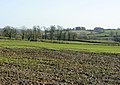
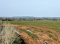
English: Stratton-on-the-Fosse is a village and civil parish located on the edge of the Mendip Hills from Frome, in Somerset, England. It has a population of about 1,200 and has a rural agricultural landscape, although it was part of the once-thriving Somerset coalfield. Within the boundaries of the parish are the hamlets of Benter and Nettlebridge.
village in the United Kingdom  | |||||
| Carica un file multimediale | |||||
| Istanza di | |||||
|---|---|---|---|---|---|
| Luogo | Mendip, Somerset, Sud Ovest dell'Inghilterra, Inghilterra | ||||
| Popolazione |
| ||||
 | |||||
Sottocategorie
Questa categoria contiene le 3 sottocategorie indicate di seguito, su un totale di 3.
D
- Downside Abbey (33 F)
File nella categoria "Stratton-on-the-Fosse"
Questa categoria contiene 56 file, indicati di seguito, su un totale di 56.
-
 2010 , A367 passing St.Olivers, Downside - geograph.org.uk - 1869109.jpg 800 × 430; 123 KB
-

-
 2010 , House for sale on Church Lane - geograph.org.uk - 1869084.jpg 800 × 663; 195 KB
-
-
 2011 , A367 heading north through Nettlebridge - geograph.org.uk - 2230549.jpg 2 568 × 2 177; 2,43 MB
-
 2011 , The George, Nettlebridge - geograph.org.uk - 2226392.jpg 1 600 × 903; 385 KB
-
 A soggy entrance - geograph.org.uk - 4797647.jpg 2 304 × 1 704; 1,78 MB
-
 A361 from entrance to Middlemead - geograph.org.uk - 5532010.jpg 640 × 503; 65 KB
-
 A367 above Nettlebridge - geograph.org.uk - 1484416.jpg 640 × 505; 174 KB
-
 A367 entering Stratton-on-the-Fosse - geograph.org.uk - 5531998.jpg 640 × 501; 86 KB
-
 B3355 junction from Fosse way - geograph.org.uk - 5532020.jpg 640 × 427; 54 KB
-
 Barlake Farm - geograph.org.uk - 137602.jpg 640 × 480; 88 KB
-
 Blackey Lane, Benter - geograph.org.uk - 5761849.jpg 4 000 × 3 000; 5,11 MB
-
 Chimneys hiding in the woods - geograph.org.uk - 4797716.jpg 2 304 × 1 704; 1,61 MB
-
 Cottage on Pitcot Lane - geograph.org.uk - 1250683.jpg 640 × 501; 171 KB
-
 Crossroads north of Nettlebridge - geograph.org.uk - 5531948.jpg 640 × 305; 63 KB
-
 Daffodils on Pitcot Lane - geograph.org.uk - 1250849.jpg 640 × 513; 150 KB
-

-

-
-
-
 Downside Abbey - geograph.org.uk - 4261979.jpg 1 500 × 1 000; 320 KB
-
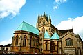
 Downside Abbey - geograph.org.uk - 6156226.jpg 5 472 × 3 648; 5,07 MB
-
 Downside Abbey - geograph.org.uk - 6156230.jpg 5 472 × 3 648; 5,57 MB
-
 Farmyard on Pitcot Lane - geograph.org.uk - 1245660.jpg 640 × 478; 161 KB
-
 Field near Killings Knap - geograph.org.uk - 1068815.jpg 640 × 455; 213 KB
-
 Field near Killings Knap Farm - geograph.org.uk - 1058866.jpg 640 × 480; 263 KB
-
 Keeping pupils and the public apart - geograph.org.uk - 3513651.jpg 3 264 × 2 448; 1,68 MB
-
 King's Arms, Stratton-on-the-Fosse - geograph.org.uk - 1398953.jpg 640 × 480; 96 KB
-
 Lay by just north of B3356 junction - geograph.org.uk - 5531956.jpg 640 × 446; 68 KB
-
 Lay by south of Watery Lane junction - geograph.org.uk - 5532015.jpg 640 × 486; 55 KB
-
 Looking east from Wells Road, B3139 - geograph.org.uk - 1068836.jpg 640 × 453; 232 KB
-
 Looking for Chaos - geograph.org.uk - 4797624.jpg 2 304 × 1 704; 1,69 MB
-
 Looking north on Pitcot Lane - geograph.org.uk - 1217265.jpg 640 × 468; 131 KB
-
 Maize stubble seen from Sweet Leaze Lane - geograph.org.uk - 1250941.jpg 640 × 447; 136 KB
-
 Minor road to Pitcot - geograph.org.uk - 1250866.jpg 640 × 509; 198 KB
-
 Muddy track near Stratton-on-the-Fosse - geograph.org.uk - 1066860.jpg 640 × 466; 278 KB
-
 Not a reassuring sign - geograph.org.uk - 4797664.jpg 1 704 × 2 304; 2,35 MB
-

-

-

-
 Pasture on Pitcot Lane - geograph.org.uk - 1250830.jpg 640 × 480; 130 KB
-
 Pitcot Lane, Benter - geograph.org.uk - 5761853.jpg 4 000 × 3 000; 4,5 MB
-

-
 Restricted Byway - geograph.org.uk - 4797631.jpg 1 704 × 2 304; 2,18 MB
-
 Shivering in the frost - geograph.org.uk - 4797710.jpg 1 704 × 2 304; 2,42 MB
-

-
 Stoke Bottom Farm - geograph.org.uk - 4797639.jpg 2 304 × 1 704; 2,2 MB
-
 Straight up the lane - geograph.org.uk - 4797641.jpg 2 304 × 1 704; 1,69 MB
-

-
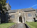 The church of St Vigor at Stratton-on-the-Fosse - geograph.org.uk - 3373918.jpg 4 000 × 3 000; 3,58 MB
-
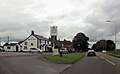 The White post public house - geograph.org.uk - 5532031.jpg 640 × 394; 50 KB
-
-
 Upper Benter - geograph.org.uk - 137597.jpg 640 × 480; 81 KB
-
 Downside School - geograph.org.uk - 395625.jpg 640 × 356; 50 KB
-
 Field of ripening wheat - geograph.org.uk - 457805.jpg 640 × 480; 124 KB


