Category:Sutton Valence
Vai alla navigazione
Vai alla ricerca
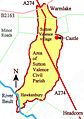
English: Sutton Valence is a village some five miles SE of Maidstone, Kent, England on the Greensand Ridge overlooking the Vale of Kent and Weald. One of the main landmarks in the village is Sutton Valence Castle, of which only the ruins of the 12th century keep remain, under the ownership of English Heritage, open any reasonable time. Sutton Valence School, a leading independent school is located in the north-west part of the village but also owns Art and Design Technology departments in the centre of the village. There is also a primary school for the young children of the village. Many of the older buildings in the village are constructed from ragstone formerly mined locally at Boughton Monchelsea.
parrocchia civile del Kent  | |||||
| Carica un file multimediale | |||||
| Istanza di | |||||
|---|---|---|---|---|---|
| Luogo | Maidstone, Kent, Sud Est dell'Inghilterra, Inghilterra | ||||
| Popolazione |
| ||||
| Considerato essere uguale a | Sutton Valence (pagina Wikimedia duplicata, parrocchia civile dell'Inghilterra) | ||||
| sito web ufficiale | |||||
 | |||||
Sottocategorie
Questa categoria contiene le 5 sottocategorie indicate di seguito, su un totale di 5.
O
- Oasts in Sutton Valence (16 F)
S
- St Mary's church, Sutton Valence (14 F)
- Sutton Valence Castle (17 F)
- Sutton Valence School (20 F)
- Sutton Valence War Memorial (2 F)
File nella categoria "Sutton Valence"
Questa categoria contiene 200 file, indicati di seguito, su un totale di 239.
(pagina precedente) (pagina successiva)-
 002osd000000017u00382000.jpg 4 000 × 2 287; 2,82 MB
-

-
 A274 crossroads with Warmlake Road - geograph.org.uk - 2791945.jpg 3 568 × 2 658; 1,58 MB
-
 A274 heads towards Sutton Valance - geograph.org.uk - 2791639.jpg 3 530 × 2 523; 1,07 MB
-
 Almshouses on High Street - geograph.org.uk - 1942470.jpg 1 024 × 768; 259 KB
-
 Apple orchard, off of Chart Rd - geograph.org.uk - 1157554.jpg 640 × 430; 87 KB
-
 Apple orchard, south of Chart Rd - geograph.org.uk - 1157551.jpg 640 × 430; 90 KB
-
 Aylmer House, Tumblers Hill, Sutton Valence - geograph.org.uk - 1942343.jpg 1 024 × 768; 171 KB
-
 Babylon Farm - geograph.org.uk - 1261797.jpg 640 × 480; 118 KB
-
 Babylon Lane - geograph.org.uk - 3333471.jpg 2 464 × 1 632; 957 KB
-
 Babylon Lane - geograph.org.uk - 3333474.jpg 2 464 × 1 632; 963 KB
-
 Babylon Lane, Hawkenbury - geograph.org.uk - 5645025.jpg 1 024 × 768; 169 KB
-
 Baker Lane - geograph.org.uk - 3370500.jpg 640 × 426; 75 KB
-
 Baker Lane, Sutton Valence - geograph.org.uk - 4901893.jpg 3 264 × 2 448; 3,1 MB
-
 Barn by New Barn Road - geograph.org.uk - 6421513.jpg 6 000 × 4 000; 6,84 MB
-
 Barn by New Barn Road - geograph.org.uk - 6423785.jpg 6 000 × 4 000; 6,43 MB
-
 Barn, Hawkenbury - geograph.org.uk - 4924100.jpg 640 × 426; 68 KB
-
 Barn, Hawkenbury - geograph.org.uk - 4924104.jpg 640 × 426; 70 KB
-
 Barn, Manor Farm - geograph.org.uk - 3370554.jpg 640 × 426; 35 KB
-
 Boyton Court Rd - geograph.org.uk - 3367840.jpg 640 × 426; 79 KB
-
 Boyton Court Road looking towards Boyton Court Oast - geograph.org.uk - 3680632.jpg 4 000 × 3 000; 3,96 MB
-
 Boyton Court Road, Sutton Valence - geograph.org.uk - 4901911.jpg 3 264 × 2 448; 2,1 MB
-
 Bridleway to Sutton Valence - geograph.org.uk - 1261769.jpg 640 × 480; 71 KB
-
 Broad Street - geograph.org.uk - 2176628.jpg 640 × 480; 92 KB
-
 Broad Street, Sutton Valence - geograph.org.uk - 2138185.jpg 620 × 465; 108 KB
-
 Broad Street, Sutton Valence - geograph.org.uk - 3655990.jpg 3 488 × 2 616; 2,23 MB
-
 Broad Street, Sutton Valence - geograph.org.uk - 3655995.jpg 3 488 × 2 616; 2,18 MB
-
 Broad Street, Sutton Valence - geograph.org.uk - 3679980.jpg 4 000 × 3 000; 4,04 MB
-
 Broad Street, Sutton Valence - geograph.org.uk - 4899647.jpg 3 264 × 2 448; 2,68 MB
-
 Broad Street, Sutton Valence in 1969 - geograph.org.uk - 1708599.jpg 777 × 542; 126 KB
-
 Captain's Close, Sutton Valence - geograph.org.uk - 3656356.jpg 3 488 × 2 616; 2,26 MB
-
 Chart Road, Sutton Valence - geograph.org.uk - 4899643.jpg 3 264 × 2 448; 2,06 MB
-
 Chart Road, Sutton Valence - geograph.org.uk - 4899644.jpg 3 264 × 2 448; 1,75 MB
-
 Close-up of Sutton Valence village sign - geograph.org.uk - 3164806.jpg 3 216 × 4 288; 3,42 MB
-
 Clothworkers Arms, Pub Sign, Sutton Valence - geograph.org.uk - 2064428.jpg 2 304 × 3 072; 1,24 MB
-
 Clothworkers Arms, Sutton Valence - geograph.org.uk - 3655941.jpg 3 488 × 2 616; 2,2 MB
-
 Cottage on Chapel Lane - geograph.org.uk - 1942330.jpg 1 024 × 768; 265 KB
-
 Cows and barn by New Barn Road - geograph.org.uk - 6421547.jpg 6 000 × 4 000; 5,23 MB
-
 Cows and barn by New Barn Road - geograph.org.uk - 6421549.jpg 6 000 × 4 000; 5,67 MB
-
 Cows near at Viney Farm - geograph.org.uk - 2655252.jpg 640 × 480; 139 KB
-
 East of Sutton Valence - geograph.org.uk - 3370507.jpg 640 × 426; 51 KB
-
 East Sutton Rd - geograph.org.uk - 3367841.jpg 640 × 426; 83 KB
-
 East Sutton Rd - geograph.org.uk - 3367842.jpg 640 × 426; 57 KB
-
 East Sutton Rd - geograph.org.uk - 3370497.jpg 640 × 426; 96 KB
-
 Entrance to Public Bridleway - geograph.org.uk - 3333463.jpg 2 464 × 1 632; 1 014 KB
-
 Farmland, Hawkenbury - geograph.org.uk - 4924110.jpg 640 × 621; 89 KB
-
 Farthing Green Barn - geograph.org.uk - 1261792.jpg 640 × 480; 117 KB
-
 Footpath and Harvest Home - geograph.org.uk - 214793.jpg 640 × 426; 114 KB
-
 Footpath near College Farm - geograph.org.uk - 3680586.jpg 4 000 × 3 000; 4,16 MB
-
 Footpath to Moat Farm - geograph.org.uk - 214800.jpg 426 × 640; 141 KB
-
 Former oast house in Sutton Valence - geograph.org.uk - 6267738.jpg 2 329 × 3 097; 1,34 MB
-
 Forsham Lane, near Sutton Valence - geograph.org.uk - 4899660.jpg 3 264 × 2 448; 3,76 MB
-
 Forsham Lane, near Sutton Valence - geograph.org.uk - 4899662.jpg 3 264 × 2 448; 2,64 MB
-
 Forsham Lane, Sutton Valence - geograph.org.uk - 4899656.jpg 3 264 × 2 448; 1,88 MB
-
 Four Oaks Road, near Hawkenbury - geograph.org.uk - 4831126.jpg 3 264 × 2 448; 2,8 MB
-
 Gate Near Lambs Cross - geograph.org.uk - 214796.jpg 426 × 640; 132 KB
-
 Gladwish Barn - geograph.org.uk - 1196070.jpg 640 × 481; 92 KB
-
 Grand Cottages on South Lane - geograph.org.uk - 1943405.jpg 1 024 × 768; 223 KB
-
 Grazing land, Hawkenbury - geograph.org.uk - 4924117.jpg 640 × 426; 50 KB
-
 Greensand Way along the hedge - geograph.org.uk - 3370506.jpg 640 × 426; 79 KB
-
 Greensand Way entering Sutton Valence - geograph.org.uk - 3370522.jpg 640 × 426; 116 KB
-
 Greensand Way leaving Sutton Valence - geograph.org.uk - 3370530.jpg 640 × 426; 81 KB
-
 Greensand Way up the steps - geograph.org.uk - 3370503.jpg 640 × 426; 129 KB
-
 Hazelnut Orchard, Haven Farm, Sutton Valence, Kent - geograph.org.uk - 1900289.jpg 1 600 × 1 200; 846 KB
-
 Headcorn Road, near Sutton Valence - geograph.org.uk - 3656320.jpg 3 488 × 2 616; 2,2 MB
-
 Headcorn Road, near Sutton Valence - geograph.org.uk - 3656328.jpg 3 488 × 2 616; 2,21 MB
-
 Headcorn Road, Sutton Valence - geograph.org.uk - 4899652.jpg 3 264 × 2 448; 1,93 MB
-
 Headcorn Road, Sutton Valence, Kent - geograph.org.uk - 1044665.jpg 640 × 427; 87 KB
-
 Heaven Cottage (geograph 6816276).jpg 1 024 × 684; 254 KB
-
 Heaven Cottage - geograph.org.uk - 3370544.jpg 640 × 426; 92 KB
-
 Heniker Lane, near Sutton Valence - geograph.org.uk - 3656347.jpg 3 488 × 2 616; 2,27 MB
-
 High Street, Sutton Valence - geograph.org.uk - 3680003.jpg 4 000 × 3 000; 3,83 MB
-
 High Street, Sutton Valence - geograph.org.uk - 3680009.jpg 4 000 × 3 000; 4,1 MB
-
 High Street, Sutton Valence - geograph.org.uk - 4899646.jpg 3 264 × 2 448; 1,79 MB
-
 Hilltop Garage - geograph.org.uk - 3370547.jpg 640 × 426; 81 KB
-
 Horses by South Lane - geograph.org.uk - 2956877.jpg 640 × 480; 118 KB
-

-
 Houses on Lower Road - geograph.org.uk - 2956880.jpg 640 × 480; 124 KB
-
 Information board at Sutton Valence Castle - geograph.org.uk - 6267353.jpg 4 000 × 3 000; 4,85 MB
-
 Junction at Chartway Street - geograph.org.uk - 4846323.jpg 800 × 391; 81 KB
-

-
 King's Head, Sutton Valence - geograph.org.uk - 3655929.jpg 3 488 × 2 616; 2,25 MB
-
 Kings Head - geograph.org.uk - 3370542.jpg 640 × 426; 68 KB
-
 Kings Head sign - geograph.org.uk - 2166921.jpg 640 × 480; 83 KB
-
 Kings Head, Sutton Valence - geograph.org.uk - 2166918.jpg 640 × 480; 93 KB
-
 Lambe's Almshouses - geograph.org.uk - 1013040.jpg 640 × 427; 102 KB
-
 Lambe's Almshouses - geograph.org.uk - 1015784.jpg 640 × 427; 103 KB
-
 Lane near Sutton Valence - geograph.org.uk - 3680596.jpg 4 000 × 3 000; 4,39 MB
-
 Line of trees - geograph.org.uk - 3375080.jpg 640 × 426; 39 KB
-
 Lower Farm House - geograph.org.uk - 1263989.jpg 640 × 480; 81 KB
-
 Lower Road, Sutton Valence - geograph.org.uk - 4899648.jpg 3 264 × 2 448; 1,7 MB
-
 Manor Farm - geograph.org.uk - 3370551.jpg 640 × 426; 87 KB
-
 Nearly Collapsed - geograph.org.uk - 346439.jpg 640 × 428; 320 KB
-
 New Barn Rd - geograph.org.uk - 4924114.jpg 640 × 426; 76 KB
-
 New Barn Road, Hawkenbury - geograph.org.uk - 4831122.jpg 3 264 × 2 448; 1,94 MB
-
 North Street, Sutton Valence - geograph.org.uk - 4899650.jpg 3 264 × 2 448; 1,64 MB
-
 Oakdene Farm - panoramio.jpg 3 648 × 2 736; 4,41 MB
-
 Oast House - geograph.org.uk - 6248900.jpg 5 184 × 3 456; 1,79 MB
-
 Oast House - geograph.org.uk - 6248901.jpg 3 456 × 5 184; 1,56 MB
-
 Oast House at Thornhill Farm, Headcorn Road, Sutton Valence - geograph.org.uk - 6421512.jpg 5 850 × 3 900; 7,35 MB
-
 Oast House Cowl - geograph.org.uk - 6248903.jpg 3 403 × 4 538; 645 KB
-
 Osborne House (geograph 6816236).jpg 1 024 × 684; 246 KB
-
 Parkenden Farmhouse - geograph.org.uk - 1261786.jpg 640 × 480; 107 KB
-
 Petrol Station, A274, Sutton Valence - geograph.org.uk - 1157455.jpg 640 × 430; 89 KB
-
 Pleasure House Lane, Sutton Valence - geograph.org.uk - 4901896.jpg 3 264 × 2 448; 2,21 MB
-
 PO Shaw memorial Chart Road.jpg 935 × 661; 76 KB
-
 Post box at the junction - geograph.org.uk - 2956781.jpg 640 × 428; 134 KB
-
 Queens Head sign - geograph.org.uk - 2166928.jpg 640 × 640; 114 KB
-
 Raspberry fields in Sutton Valence - panoramio (1).jpg 1 600 × 1 200; 254 KB
-
 Raspberry fields in Sutton Valence - panoramio.jpg 3 648 × 2 736; 4,06 MB
-
 Rectory Lane - geograph.org.uk - 1015801.jpg 640 × 427; 107 KB
-
 Road junction at Five Wents - geograph.org.uk - 4846333.jpg 800 × 466; 90 KB
-
 Scene near College Farm - geograph.org.uk - 3680578.jpg 4 000 × 3 000; 4,18 MB
-
 School Lane - geograph.org.uk - 3370537.jpg 640 × 426; 86 KB
-
 School Lane, Sutton Valence - geograph.org.uk - 4901879.jpg 3 264 × 2 448; 2,51 MB
-
 School Lane, Sutton Valence - geograph.org.uk - 4901884.jpg 3 264 × 2 448; 2,34 MB
-
 South Bank, Sutton Valence - geograph.org.uk - 3655952.jpg 3 488 × 2 616; 2,19 MB
-
 South Lane, Sutton Valence - geograph.org.uk - 3655945.jpg 3 488 × 2 616; 2,26 MB
-
 South Lane, Sutton Valence - geograph.org.uk - 3656350.jpg 3 488 × 2 616; 2,25 MB
-
 South Lane, Sutton Valence - geograph.org.uk - 3656354.jpg 3 488 × 2 616; 2,27 MB
-
 South Lane, Sutton Valence - geograph.org.uk - 4844613.jpg 800 × 390; 67 KB
-
 Sparks Hall - geograph.org.uk - 1261755.jpg 640 × 480; 103 KB
-
 St Mary's Church, Sutton Valence - geograph.org.uk - 6267696.jpg 3 663 × 2 747; 2,01 MB
-
 St Mary's Church, Sutton Valence - geograph.org.uk - 6267732.jpg 3 691 × 2 769; 2,13 MB
-
 Stream by Babylon Lane - geograph.org.uk - 2956865.jpg 640 × 480; 120 KB
-

-
 Sutton Valence - geograph.org.uk - 1015810.jpg 640 × 427; 78 KB
-
 Sutton Valence - geograph.org.uk - 1113747.jpg 480 × 640; 143 KB
-
 Sutton Valence - geograph.org.uk - 1113761.jpg 640 × 480; 89 KB
-
 Sutton Valence - geograph.org.uk - 2209919.jpg 1 140 × 764; 528 KB
-
 Sutton Valence - geograph.org.uk - 2209921.jpg 1 152 × 784; 391 KB
-
 Sutton Valence - geograph.org.uk - 3370535.jpg 640 × 426; 65 KB
-
 Sutton Valence buildings (3) (geograph 7079269).jpg 3 240 × 4 320; 2,52 MB
-
 Sutton Valence buildings (4) (geograph 7079274).jpg 4 320 × 3 240; 3,49 MB
-
 Sutton Valence buildings (6) (geograph 7079285).jpg 4 320 × 3 240; 3,07 MB
-
 Sutton Valence buildings (7) (geograph 7080094).jpg 4 320 × 3 240; 2,36 MB
-
 Sutton Valence buildings (9) (geograph 7080101).jpg 4 320 × 3 240; 3,28 MB
-
 Sutton Valence Castle - geograph.org.uk - 6267344.jpg 4 000 × 3 000; 4,6 MB
-
 Sutton Valence Castle - geograph.org.uk - 6267347.jpg 3 747 × 2 811; 2,82 MB
-
 Sutton Valence Castle - geograph.org.uk - 6267349.jpg 3 373 × 2 531; 2,1 MB
-
 Sutton Valence Clocktower - geograph.org.uk - 4415054.jpg 480 × 640; 35 KB
-
 Sutton Valence houses (1) (geograph 7078471).jpg 3 240 × 4 320; 3,19 MB
-
 Sutton Valence houses (12) (geograph 7079229).jpg 4 320 × 3 240; 3,35 MB
-
 Sutton Valence houses (13) (geograph 7079231).jpg 4 320 × 3 240; 3,88 MB
-
 Sutton Valence houses (14) (geograph 7079289).jpg 4 223 × 3 167; 2,54 MB
-
 Sutton Valence houses (15) (geograph 7079295).jpg 3 911 × 2 933; 2,22 MB
-
 Sutton Valence houses (16) (geograph 7080090).jpg 3 971 × 2 979; 2,85 MB
-
 Sutton Valence houses (17) (geograph 7080091).jpg 4 223 × 3 167; 2,54 MB
-
 Sutton Valence houses (2) (geograph 7078472).jpg 4 320 × 3 240; 2,88 MB
-
 Sutton Valence houses (22) (geograph 7080098).jpg 4 320 × 3 240; 3,09 MB
-
 Sutton Valence houses (23) (geograph 7080103).jpg 4 320 × 3 240; 2,61 MB
-
 Sutton Valence houses (24) (geograph 7080105).jpg 3 882 × 2 911; 2,51 MB
-
 Sutton Valence houses (25) (geograph 7080115).jpg 4 320 × 3 240; 3,55 MB
-
 Sutton Valence houses (26) (geograph 7080834).jpg 3 240 × 4 320; 3,43 MB
-
 Sutton Valence houses (27) (geograph 7080836).jpg 2 504 × 3 339; 2,24 MB
-
 Sutton Valence houses (28) (geograph 7080837).jpg 4 320 × 3 240; 3,58 MB
-
 Sutton Valence houses (29) (geograph 7080839).jpg 3 913 × 2 935; 2,66 MB
-
 Sutton Valence houses (30) (geograph 7080841).jpg 4 320 × 3 240; 2,84 MB
-
 Sutton Valence houses (4) (geograph 7078492).jpg 4 320 × 3 240; 3,52 MB
-
 Sutton Valence houses (6) (geograph 7078496).jpg 4 223 × 3 167; 3,28 MB
-
 Sutton Valence Kings Head outside.jpg 1 417 × 777; 93 KB
-
 Sutton Valence mill base.JPG 2 304 × 1 728; 776 KB
-
 Sutton Valence Road sign.jpg 935 × 1 526; 98 KB
-
 Sutton Valence School - geograph.org.uk - 1157450.jpg 640 × 430; 82 KB
-
 Sutton Valence School - geograph.org.uk - 3370518.jpg 640 × 426; 53 KB
-
 Sutton Valence School - geograph.org.uk - 3370524.jpg 640 × 426; 64 KB
-
 Sutton Valence School - geograph.org.uk - 3370525.jpg 640 × 426; 47 KB
-
 Sutton Valence School - geograph.org.uk - 3370527.jpg 640 × 426; 79 KB
-
 Sutton Valence School - geograph.org.uk - 4846320.jpg 800 × 498; 113 KB
-
 Sutton Valence Village Sign - geograph.org.uk - 3164797.jpg 3 216 × 4 288; 3,72 MB
-
 Sutton Valence Wastewater Treatment Works (1) - geograph.org.uk - 4412191.jpg 4 608 × 3 456; 6,7 MB
-
 Sutton Valence Wastewater Treatment Works (2) - geograph.org.uk - 4412193.jpg 4 608 × 3 456; 6,61 MB
-
 SV CP diag.jpg 1 134 × 1 612; 91 KB
-
 SV crest.jpg 2 053 × 2 125; 164 KB
-
 The Clothworkers Arms - geograph.org.uk - 6422738.jpg 6 000 × 4 000; 6,27 MB
-
 The Clothworkers Arms sign - geograph.org.uk - 6422736.jpg 2 606 × 3 474; 1,68 MB
-
 The Clothworkers Arms, Sutton Valence - geograph.org.uk - 1942319.jpg 1 024 × 768; 253 KB
-
 The Greensand Way - geograph.org.uk - 3375081.jpg 640 × 426; 47 KB
-
 The Harbour, Sutton Valence - geograph.org.uk - 3656351.jpg 3 488 × 2 616; 2,28 MB
-
 The King's Head pub, Sutton Valence - geograph.org.uk - 1180998.jpg 640 × 481; 75 KB
-
 The King's Head, Sutton Valence - geograph.org.uk - 1157456.jpg 640 × 430; 90 KB
-
 The Kings Head sign - geograph.org.uk - 6422733.jpg 4 645 × 3 484; 2,96 MB
-
 The Lambe Almshouses, Sutton Valence - geograph.org.uk - 3680021.jpg 4 000 × 3 000; 4,4 MB
-

-
 The Platt, Sutton Valence - geograph.org.uk - 3655955.jpg 3 488 × 2 616; 2,21 MB
-
 The Plough - panoramio.jpg 2 272 × 1 704; 878 KB
-
 The Plough at Langley, Five Wents - geograph.org.uk - 2111384.jpg 3 488 × 2 052; 2,12 MB
-
 The Plough at Langley, Five Wents - geograph.org.uk - 3608825.jpg 3 488 × 2 616; 2,18 MB
-
 The Queen's Head pub, Sutton Valence - geograph.org.uk - 1180996.jpg 640 × 481; 64 KB
-
 The Queen's Head, Sutton Valence - geograph.org.uk - 3655934.jpg 3 488 × 2 616; 2,15 MB
-
 The Queens Head sign - geograph.org.uk - 6422732.jpg 3 339 × 4 451; 2,41 MB
-
 The Queens Head, Sutton Valence - geograph.org.uk - 2166927.jpg 640 × 480; 69 KB
-
 The steps up to Sutton Valence Castle from Rectory Lane - geograph.org.uk - 3679916.jpg 4 000 × 3 000; 4,13 MB
-

-
 The Swan sign - geograph.org.uk - 2176621.jpg 480 × 640; 83 KB
-
 The Swan, Broad Street - geograph.org.uk - 3996174.jpg 913 × 684; 150 KB
-
 The Swan, Pub Sign, Sutton Valence - geograph.org.uk - 2064355.jpg 1 728 × 3 072; 1,3 MB
-
 The Swan, Sutton Valence - geograph.org.uk - 2176620.jpg 640 × 480; 76 KB
-
 The Swan, Sutton Valence - geograph.org.uk - 3655983.jpg 3 488 × 2 616; 2,14 MB
-
 The view from Sutton Valence Castle - geograph.org.uk - 6267350.jpg 4 000 × 3 000; 4,75 MB


.jpg)


.jpg)


.jpg)


_(geograph_7079269).jpg)
_(geograph_7079274).jpg)
_(geograph_7079285).jpg)
_(geograph_7080094).jpg)
_(geograph_7080101).jpg)


_(geograph_7078471).jpg)
_(geograph_7079229).jpg)
_(geograph_7079231).jpg)
_(geograph_7079289).jpg)
_(geograph_7079295).jpg)
_(geograph_7080090).jpg)
_(geograph_7080091).jpg)
_(geograph_7078472).jpg)
_(geograph_7080098).jpg)
_(geograph_7080103).jpg)
_(geograph_7080105).jpg)
_(geograph_7080115).jpg)
_(geograph_7080834).jpg)
_(geograph_7080836).jpg)
_(geograph_7080837).jpg)
_(geograph_7080839).jpg)
_(geograph_7080841).jpg)
_(geograph_7078492).jpg)
_(geograph_7078496).jpg)


_-_geograph.org.uk_-_4412191.jpg)
_-_geograph.org.uk_-_4412193.jpg)


