Category:Taiga
Pereiti į navigaciją
Jump to search
biome characterized by coniferous forests  Местоположение на Земном шаре | |||||
| Įkelti mediją | |||||
| Tai yra |
| ||||
|---|---|---|---|---|---|
| Poklasis | |||||
| |||||
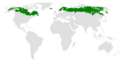
English: The Taiga and Boreal forest is a Terrestrial Biome in the subarctic regions and habitat zones of the earth.
- The term Taiga is primarily used in Europe and Asia, and the term Boreal forest is primarily used in North America.
- The Taiga and Boreal forest biome's ecoregions cover most of subarctic inland Norway, Sweden, Finland, Russia (Karelia, Siberia, and Russian Far East), northern Kazakhstan, Canada, Alaska, and the extreme north-central United States and subalpine habitat zones across the higher U.S. mountain ranges.
Subkategorijos
Rodomos 8 subkategorijos (iš viso yra 8 subkategorijos).
A
- Boreal forest of Alaska (33 F)
B
- Borealer Nadelwald (1 P, 3 F)
C
E
N
S
T
- Tayozhnyy (ship, 1958) (2 F)
Daugialypės terpės rinkmenos kategorijoje „Taiga“
Rodomi 53 šios kategorijos rinkmenos (iš viso kategorijoje yra 53 rinkmenos).
-
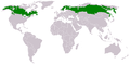
 Distribution Taiga.png 800 × 398; 109 KiB
-
 Taiga ecoregion.png 3 539 × 1 769; 565 KiB
-
 Major habitat type CAN USA.svg 1 712 × 1 992; 772 KiB
-
 Balsam Lake Mountain fire tower.jpg 1 653 × 2 356; 875 KiB
-
-
 Biome map 06.svg 1 119 × 608; 5,27 MiB
-
 Birke-fyrreskov.JPG 480 × 640; 152 KiB
-
 Burnt Forest at Rocky Point Trail of Glacier National Park USA.jpg 2 048 × 1 360; 3,05 MiB
-
De-Taiga.ogg 1,7 s; 18 KiB
-
 Dense balsam fir near West Kill Mountain summit, Spruceton, NY.jpg 5 688 × 4 032; 20,76 MiB
-
 Devil's Path in boreal forest near summit of West Kill Mountain, Spruceton, NY.jpg 3 776 × 6 048; 22,95 MiB
-
 Dsc (258672243).jpeg 1 200 × 800; 439 KiB
-
 Fire Morels.jpg 650 × 435; 189 KiB
-
 Flickr - Nicholas T - Boreal Conifer Bog.jpg 3 065 × 4 342; 9,12 MiB
-
 Forest (5161573).jpeg 2 048 × 971; 1,09 MiB
-
 Forest Fire Stopper (3403590240).jpg 1 100 × 730; 156 KiB
-
 Henri Jacob.jpg 396 × 528; 79 KiB
-
 Jack Pine branches and cones (7aa4b1a7-963e-4740-af64-9064f700b983).jpg 960 × 1 280; 1,08 MiB
-
 L'Action boréale de l'Abitibi-Témiscamingue.jpg 750 × 750; 145 KiB
-
 Larix laricina.jpg 600 × 400; 210 KiB
-

-
 Mapa del bioma de Taiga.png 1 080 × 536; 157 KiB
-

-
 Monokultur und Taiga.jpg 3 171 × 1 905; 8,76 MiB
-
 Quaking Aspen Tree Trunk (97cb49eb-7497-405a-9838-e2e9b12b4b17).jpg 960 × 1 440; 731 KiB
-

-
 Reh 00018.jpg 512 × 768; 273 KiB
-
 Rivière Batiscan, parc des Chutes-de-Montauban 001.jpg 2 048 × 1 536; 829 KiB
-
 Rivière Batiscan, parc des Chutes-de-Montauban 002.jpg 1 536 × 2 048; 1,13 MiB
-
 Rivière Batiscan, parc des Chutes-de-Montauban 003.jpg 2 048 × 1 536; 959 KiB
-
 Rivière Batiscan, parc des Chutes-de-Montauban 004.jpg 2 048 × 1 536; 913 KiB
-
 Southwest Hunter Mountain from Geiger Point, Hunter, NY.jpg 2 730 × 2 226; 1,5 MiB
-
 Spring view of Thomas Cole Mountain.jpg 6 105 × 2 306; 8,03 MiB
-
 Steppe im Übergang zum borealen Nadelwald, Mongolei.jpg 3 888 × 2 592; 5,58 MiB
-
 Summit of Cornell Mountain, Shandaken, NY.jpg 4 000 × 3 000; 7,9 MiB
-
 Taiga - panoramio.jpg 1 600 × 1 200; 346 KiB
-
 Taiga assemblage.png 640 × 870; 2,62 MiB
-
 Taiga biome and Caledonian forest ecoregion.svg 1 062 × 531; 6,8 MiB
-
 Taiga biome.svg 1 062 × 531; 6,8 MiB
-
 Taiga und Grünland im Bereich des Princess Lodge Camp, Mongolei II.jpg 3 888 × 2 592; 5,76 MiB
-
 Taiga und Grünland im Bereich des Princess Lodge Camp, Mongolei.jpg 3 733 × 2 363; 7,65 MiB
-
 Taiga.png 1 262 × 628; 29 KiB
-
 Traces of Arctic fox (film) - panoramio.jpg 2 128 × 1 520; 978 KiB
-
 Tree shadows.jpg 1 244 × 827; 218 KiB
-
 Vantaa ilmastodiagrammi.png 491 × 720; 10 KiB
-
 View northeast from Panther summit, Catskills.jpg 1 075 × 550; 329 KiB
-
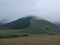 Wolkenverhangener Berg in der Nähe des Jalman Meadows Wilderness Camp, Mongolei.jpg 5 184 × 3 888; 8,63 MiB
-
 Геоботанические описания.jpg 5 184 × 3 456; 10,31 MiB
-
 Колбинский.jpg 3 992 × 2 242; 3,8 MiB
-
 Пойдем со мной.jpg 4 272 × 2 848; 3,37 MiB
-
 Старый дом - panoramio (4).jpg 3 264 × 2 176; 2,68 MiB
-
 Тайга и пасеки НПЦ "АПИЛАД".png 1 262 × 628; 39 KiB
-
 Эмбрион.jpg 2 848 × 4 272; 3,04 MiB


.jpeg)


.jpeg)
.jpg)

.jpg)


.jpg)


.jpg)


_-_panoramio.jpg)


.jpg)

