Category:Tanaga Island
Vai alla navigazione
Vai alla ricerca
island in Aleutians West Census Area, Alaska, United States  Els volvans Tanaga i East Tanaga a l'illa Tanaga, Alaska.  | |||||
| Carica un file multimediale | |||||
| Istanza di | |||||
|---|---|---|---|---|---|
| Parte di | |||||
| Luogo | census area delle Aleutine Occidentali, Unorganized Borough, Alaska, Stati Uniti d'America | ||||
| Situato sul mare / lago / fiume | |||||
| Larghezza |
| ||||
| Lunghezza |
| ||||
| Punto più alto |
| ||||
| Popolazione |
| ||||
| Superficie |
| ||||
 | |||||
Sottocategorie
Questa categoria contiene un'unica sottocategoria, indicata di seguito.
M
- Mount Takawangha (2 F)
File nella categoria "Tanaga Island"
Questa categoria contiene 12 file, indicati di seguito, su un totale di 12.
-
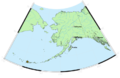
 Andreanof Map.jpg 560 × 249; 24 KB
-

-
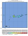 2020-01-23 Tanaga Volcano, Alaska M6.2 earthquake shakemap (USGS).jpg 815 × 1 027; 149 KB
-
 Avo map 46.png 767 × 500; 168 KB
-
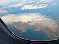 Cape Agamsik Tanaga Island Alaska.jpg 3 264 × 2 448; 1,02 MB
-
 Eastern part of Tanaga Island Alaska.jpg 3 264 × 1 632; 1,15 MB
-
 M 6.6 - 50km S of Tanaga Volcano, Alaska - intensity.jpg 612 × 720; 58 KB
-
 Old transpot ship on water.jpg 2 100 × 1 186; 91 KB
-
 Tanaga, United States (2023-11-16-08-31-41 UMBRA-05).tiff 18 216 × 21 233, 7 pagine; 508,28 MB
-
 Tanaga2003.jpg 1 600 × 1 200; 399 KB
-
 TanagaMap.png 781 × 600; 356 KB
-
 TanagaVolcano.jpg 800 × 600; 65 KB

.jpg)
.jpg)


