Category:Tantow
Zur Navigation springen
Zur Suche springen
Gemeinde im Landkreis Uckermark   | |||||
| Medium hochladen | |||||
| Ist ein(e) |
| ||||
|---|---|---|---|---|---|
| Ort |
| ||||
| Einwohnerzahl |
| ||||
| Fläche |
| ||||
| Höhe über dem Meeresspiegel |
| ||||
| offizielle Website | |||||
 | |||||
Unterkategorien
Es werden 6 von insgesamt 6 Unterkategorien in dieser Kategorie angezeigt:
In Klammern die Anzahl der enthaltenen Kategorien (K), Seiten (S), Dateien (D)
Medien in der Kategorie „Tantow“
Folgende 6 Dateien sind in dieser Kategorie, von 6 insgesamt.
-
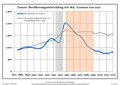 Bevölkerungsentwicklung Tantow.pdf 1.752 × 1.239; 119 KB
-
 BfTantowVorplatz.jpg 2.976 × 1.984; 2,42 MB
-
 Droga do Tantow - aleja lip - panoramio.jpg 747 × 560; 216 KB
-
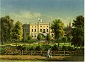 Schloss Tantow Sammlung Duncker.jpg 1.124 × 823; 276 KB
-
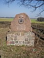 Tantow Herrmann Krueger Denkma..JPG 3.240 × 4.320; 3,48 MB
-
 Tantow, Park.JPG 3.872 × 2.592; 4,06 MB


