Category:The East Temple
Aller à la navigation
Aller à la recherche
montagne de l'Utah, aux États-Unis  | |||||
| Téléverser des médias | |||||
| Nature de l’élément | |||||
|---|---|---|---|---|---|
| Se trouve dans l'aire protégée | |||||
| Lieu | comté de Washington, Utah, É.-U. | ||||
| Chaîne de montagnes | |||||
| Proéminence |
| ||||
 | |||||
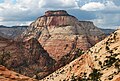
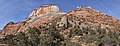
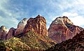
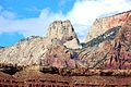
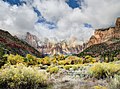
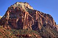
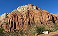
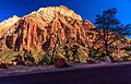
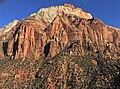
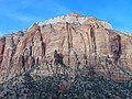
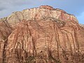
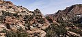
English: Media related to The East Temple, a 7,726-foot (2,355 m) Navajo Sandstone mountain in Zion National Park in Washington County, Utah, United States.
Média dans la catégorie « The East Temple »
Cette catégorie comprend 31 fichiers, dont les 31 ci-dessous.
-
 Above Zion-Mount Carmel Highway.JPG 8 057 × 2 342 ; 13,78 Mio
-
 Double Rainbow (8119673976).jpg 4 000 × 2 696 ; 3,99 Mio
-
 East aspect of The East Temple.jpg 3 058 × 1 886 ; 1,74 Mio
-
 East Temple (5978844293).jpg 2 736 × 3 648 ; 5,75 Mio
-
 East Temple (crop).jpg 1 814 × 1 222 ; 722 kio
-
 East Temple - Overlook Trail.jpg 6 629 × 2 551 ; 12,49 Mio
-

-
 Looking Down on Zion Canyon.jpg 1 622 × 1 589 ; 813 kio
-
 Mount Spry and the East Temple.jpg 12 655 × 3 500 ; 13,42 Mio
-
 Mt. Spry and East Temple.jpg 4 937 × 3 065 ; 11,07 Mio
-

-
 Navajo Sandstone cliffs (Lower Jurassic), Pine Creek Canyon, Zion National Park, sw Utah 2.jpg 3 008 × 2 000 ; 3,03 Mio
-
 Temple's Peak, Zion National Park - panoramio.jpg 5 184 × 3 456 ; 8,51 Mio
-
 Temples and Towers of the Virgin (10681212885).jpg 5 971 × 4 416 ; 19,26 Mio
-
 The East Temple from west.jpg 3 447 × 2 298 ; 1,42 Mio
-
 The East Temple from Zion-Mount Carmel Highway.jpg 3 917 × 2 447 ; 3,13 Mio
-

-
 The East Temple of Zion NP.jpg 8 254 × 5 301 ; 38,03 Mio
-
 The East Temple of Zion Park.jpg 3 862 × 2 878 ; 3,73 Mio
-
 The East Temple, from west. Zion Nation Park Utah.jpg 3 643 × 2 681 ; 2,3 Mio
-
 The East Temple, Zion National Park, Oct 16.jpg 2 592 × 1 944 ; 2,29 Mio
-
 The East Temple, Zion.jpg 2 816 × 2 112 ; 2,33 Mio
-
 The Three Wise Men and East Temple with entrance checking station in foreground. - NARA - 520368.jpg 3 000 × 2 117 ; 1,72 Mio
-
 Twin Brothers from Deertrap.jpg 4 433 × 3 466 ; 3,53 Mio
-
 View from the Overlook Trail.jpg 5 773 × 2 600 ; 6,62 Mio
-
 Washington County, UT, USA - panoramio (33).jpg 3 264 × 2 448 ; 3,18 Mio
-
 Zion National Park 1989 02.jpg 1 029 × 675 ; 854 kio
-
 Zion National Park lone tree 2005.jpeg 1 339 × 886 ; 694 kio
-
 Zion NP25.jpg 1 680 × 2 520 ; 3,39 Mio
-
 Zion, Checkerboard Mesa, East Temple (3679383491).jpg 1 600 × 1 063 ; 561 kio
-
 Zion-Mount Carmel Highway, Zion National Park, Utah (1024920771).jpg 1 600 × 1 200 ; 323 kio
.jpg)

.jpg)
.jpg)


_over_Kayenta_Fm._(Upp._Triassic-Low._Jurassic),_Pine_Creek_Canyon,_Zion_National_Park,_sw_Utah_11.jpg)
,_Pine_Creek_Canyon,_Zion_National_Park,_sw_Utah_2.jpg)

.jpg)


.jpg)


.jpg)
.jpg)
Catégories :
- Mountains of Utah
- Landforms of Washington County, Utah
- Mountains of Zion National Park
- Navajo Sandstone mountains
- 2350s mountains of the United States
- Locations along the Zion-Mount Carmel Highway in Washington County, Utah
- Locations along Utah State Route 9 in Washington County, Utah
- Locations along Utah State Route 15 (1912-1977) in Washington County, Utah
- Temple Cap Formation over Navajo Sandstone