Category:The Wash
Salti al navigilo
Salti al serĉilo
bay in England, UK  | |||||
| Alŝuti plurmedion | |||||
| Estas | |||||
|---|---|---|---|---|---|
| Parto de | |||||
| Loko | Norfolk, Oriento de Anglio, Anglio | ||||
| Ĉe akvokorpo | |||||
| Heredaĵa statuso |
| ||||
| IUCN protected areas category | |||||
| Alfluantoj | |||||
 | |||||
Subkategorioj
Ĉi tiu kategorio havas la 5 jenajn subkategoriojn, el 5 entute.
L
- Lynn and Inner Dowsing Wind Farm (36 D)
S
- Snettisham RSPB reserve (26 D)
T
- The Outer Trial Bank (7 D)
W
- Wash Monster (8 D)
Dosieroj en kategorio “The Wash”
La jenaj 73 dosieroj estas en ĉi tiu kategorio, el 73 entute.
-

-
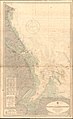
 Admiralty Chart No 108 The Wash, Published 1924.jpg 16 165 × 11 100; 77,83 MB
-
 Admiralty Chart No 1177 Approaches to King's Lynn, Published 1920.jpg 11 056 × 16 213; 60 MB
-
 Admiralty Chart No 1190 Blakeney to Flamborough Head, Published 1951.jpg 11 260 × 18 347; 72,75 MB
-

-
 Beams of light (geograph 4202622).jpg 3 456 × 4 608; 3,25 MB
-
 Breakers in the Wash - geograph.org.uk - 2579874.jpg 3 872 × 2 592; 3,5 MB
-
 Buoy 13N - geograph.org.uk - 5469316.jpg 640 × 372; 41 KB
-
 Centre Port plan over The Wash.svg 1 152 × 768; 1,2 MB
-
 Channel’s edge - geograph.org.uk - 2624119.jpg 3 872 × 2 592; 3,33 MB
-
 Corner of the gridsquare - geograph.org.uk - 1492553.jpg 640 × 480; 58 KB
-

-
 Heading towards River Welland - geograph.org.uk - 5469922.jpg 640 × 460; 47 KB
-
 Hunstanton - Kings Lynn, Norflok UK (46454553075).jpg 2 592 × 1 944; 809 KB
-

-
 Isolated peaks - geograph.org.uk - 3685765.jpg 3 264 × 2 448; 1,8 MB
-
 King's Lynn and River Ouse, Norfolk, UK (46454553215).jpg 1 156 × 867; 229 KB
-
 Looking back to Hunstanton - geograph.org.uk - 3685702.jpg 3 264 × 2 448; 1,78 MB
-
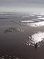
 Low tide in the Wash, aerial 2015 - geograph.org.uk - 4667755.jpg 640 × 427; 30 KB
-
 Mud and marshland - geograph.org.uk - 1432261.jpg 640 × 480; 65 KB
-
 Mud crevasses at Crab's Hole - geograph.org.uk - 1419872.jpg 640 × 480; 93 KB
-
 National Grid square TF at 1 in 250 000 scale.gif 4 000 × 4 000; 2,36 MB
-
 National Grid square TF at 1 in 250 000 scale.png 4 000 × 4 000; 1,92 MB
-
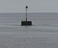
 Navigation beacon - geograph.org.uk - 5469939.jpg 640 × 480; 46 KB
-
 Navigation beacon, Dolly's Peg - geograph.org.uk - 5469910.jpg 640 × 480; 45 KB
-
 Navigation beacon, Dolly's Peg - geograph.org.uk - 5469912.jpg 640 × 480; 45 KB
-
 Navigation buoy - geograph.org.uk - 5469915.jpg 640 × 480; 50 KB
-
 Navigation buoy - geograph.org.uk - 5469917.jpg 640 × 480; 49 KB
-
 Navigation buoy 13N - geograph.org.uk - 5469919.jpg 640 × 480; 57 KB
-
 Navigation marker at Tabs Head - geograph.org.uk - 3698422.jpg 1 498 × 1 234; 518 KB
-
 Off shore island - geograph.org.uk - 14787.jpg 640 × 417; 38 KB
-
 Ordnance Survey One-Inch Sheet 114 Boston & Skegness, Published 1947.jpg 10 945 × 12 789; 14,8 MB
-
 Ordnance Survey One-Inch Sheet 114 Boston & Skegness, Published 1962.jpg 8 252 × 9 876; 8,89 MB
-
 Ordnance Survey One-Inch Sheet 124 King's Lynn, Published 1946.jpg 10 958 × 12 774; 13,86 MB
-
 Ordnance Survey One-Inch Sheet 124 King's Lynn, Published 1963.jpg 8 275 × 9 912; 9,7 MB
-
 Roaring Middle light float - geograph.org.uk - 638833.jpg 640 × 475; 55 KB
-
 Ruth Do328 Wash 16.08.12R edited-2.jpg 1 024 × 710; 323 KB
-

-

-
 Sands of the Wash - geograph.org.uk - 3685747.jpg 2 448 × 3 264; 1,75 MB
-
 Seals in the Wash - geograph.org.uk - 2126112.jpg 3 072 × 2 304; 1,47 MB
-
 Seat looking to Tabs Head - geograph.org.uk - 1495639.jpg 4 000 × 3 000; 2,92 MB
-
 Shipwreck in The Wash - geograph.org.uk - 1491978.jpg 640 × 480; 83 KB
-
 Silver mud, the Wash.jpg 640 × 480; 93 KB
-
 Silver Sand - geograph.org.uk - 3685668.jpg 3 264 × 2 448; 1,78 MB
-
 Silver Sand - geograph.org.uk - 3685689.jpg 3 264 × 2 448; 1,87 MB
-
 Silver Sand and Hunstanton - geograph.org.uk - 3685684.jpg 3 264 × 2 448; 1,82 MB
-
 Stable spit - geograph.org.uk - 3685731.jpg 2 448 × 3 264; 1,75 MB
-
 Sunset at Heacham - geograph.org.uk - 720459.jpg 640 × 387; 39 KB
-
 Sunset at Hunstanton - geograph.org.uk - 39921.jpg 640 × 480; 78 KB
-
 The Wash - geograph.org.uk - 881100.jpg 640 × 426; 93 KB
-
 The Wash - geograph.org.uk - 881103.jpg 640 × 426; 75 KB
-
 The Wash - map.png 861 × 492; 311 KB
-
 The Wash between Hunstanton and Kings Lynn 1994 - geograph.org.uk - 5228132.jpg 1 712 × 2 288; 867 KB
-
 The Wash England.svg 919 × 1 201; 1,1 MB
-
 The Wash wind farm - geograph.org.uk - 6228217.jpg 2 000 × 1 333; 1,09 MB
-
 The Wash, aerial 2013 - geograph.org.uk - 3667263.jpg 640 × 427; 38 KB
-
 The Wash, Heacham beach.jpg 800 × 600; 56 KB
-
 The Wash, Hunstanton (L) to Snettisham, Norfolk UK (46646275634).jpg 2 592 × 1 944; 1 MB
-
 The Wash, Hunstanton to Heacham, Norfolk UK (47316716362).jpg 2 592 × 1 944; 1 017 KB
-

-

-
 The Wash, seen from the sea bank - geograph.org.uk - 484403.jpg 2 048 × 3 090; 3,16 MB
-

-
 View from The Haven - geograph.org.uk - 5469907.jpg 640 × 480; 47 KB
-
 View from The Haven - geograph.org.uk - 5469909.jpg 640 × 480; 47 KB
-

-
 Waiting for a pilot - geograph.org.uk - 639093.jpg 640 × 475; 58 KB
-

-
 Wash Cows - geograph.org.uk - 602351.jpg 640 × 480; 81 KB
-
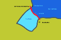
 Washmap.png 534 × 552; 10 KB
-

-
 The Wash - geograph.org.uk - 36122.jpg 640 × 426; 120 KB


.jpg)


.jpg)


.jpg)


_to_Snettisham,_Norfolk_UK_(46646275634).jpg)
.jpg)
_-_geograph.org.uk_-_3680905.jpg)


