Category:Topography
Vai alla navigazione
Vai alla ricerca
| Category Topography on sister projects: | |||||||||
|---|---|---|---|---|---|---|---|---|---|
日本語:地形学

disciplina che studia gli strumenti e i metodi per la misurazione e rappresentazione della superficie terrestre  | |||||
| Carica un file multimediale | |||||
| Istanza di |
| ||||
|---|---|---|---|---|---|
| Sottoclasse di | |||||
| Parte di | |||||
| Distinto da | |||||
| |||||
- Please use the maps and diagrams branch in any subcategory
Sottocategorie
Questa categoria contiene le 27 sottocategorie indicate di seguito, su un totale di 27.
*
+
A
B
- Breachway (6 F)
C
E
G
H
- Hypsometric curves (28 F)
L
M
O
- Optic disc topography (2 F)
S
- Topographic shading (114 F)
- Stereoplanigraphs (2 F)
T
Z
File nella categoria "Topography"
Questa categoria contiene 59 file, indicati di seguito, su un totale di 59.
-
 5minut.svg 148 × 148; 194 byte
-
 10minut.svg 148 × 148; 195 byte
-
 15minut.svg 148 × 148; 204 byte
-
 20minut.svg 148 × 148; 204 byte
-
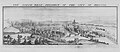 Buck NW Prospect of Bristol.jpg 8 110 × 3 528; 14,64 MB
-
 Budynek.svg 174 × 174; 138 byte
-
 Chart of discoveries of Northern Land, 1821-1822. Wellcome M0000968.jpg 1 075 × 1 562; 377 KB
-
 Chart of discovery made by the 'Victory', 1829-1832. Wellcome M0000966.jpg 1 169 × 1 474; 496 KB
-
 Chart of the Southern Hemisphere made by Captain Cook. Wellcome M0000970.jpg 1 172 × 1 434; 374 KB
-
 Clay pit showing permanent water, Herts-Beds. Wellcome M0015606.jpg 4 280 × 2 491; 1,67 MB
-
 Corner of Gray's Inn Road and Battle Bridge. Wellcome M0012501.jpg 3 945 × 2 668; 2,61 MB
-
 EinzelbaumLandmarke.jpg 347 × 211; 12 KB
-
 Field-MapBirdie2.JPG 2 128 × 2 832; 1,76 MB
-
 Flussufer.jpg 1 600 × 900; 245 KB
-
 Fockynggroue.jpg 1 174 × 204; 182 KB
-
 Foothills.jpg 280 × 187; 43 KB
-
 G. M. Wheeler, Topographical atlas 1869-1878 Wellcome L0027630.jpg 1 600 × 1 188; 645 KB
-
 Galapagos Archipelago. Wellcome L0003829.jpg 1 162 × 1 694; 816 KB
-
 Georama 1 - Geomática ES.jpg 1 288 × 966; 495 KB
-
 Georama 2 - Geomática ES.jpg 1 288 × 966; 248 KB
-
 Grobla.svg 87 × 47; 260 byte
-
 H. Chauncy, The historical antiquities of Hertfordshire Wellcome L0020613.jpg 1 646 × 1 152; 1,15 MB
-
 H. Chauncy, The historical antiquities of Hertfordshire. Wellcome L0020614.jpg 1 565 × 1 200; 1,18 MB
-
 Herstelle.jpg 861 × 594; 97 KB
-
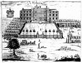
 Holland's Leaguer or Manor House of Paris Green. Wellcome L0009761.jpg 1 247 × 1 447; 612 KB
-
 IMG coastal relief of accra.jpg 3 120 × 3 120; 4,73 MB
-
 Logo HGV.jpg 868 × 868; 51 KB
-
 Material Topografico.jpg 1 836 × 3 264; 2,09 MB
-
 Material Topográfico.jpg 1 836 × 3 264; 1,34 MB
-
 Mobile mapping system backpack, avenue François-Collignon (Toulouse).jpg 1 845 × 2 768; 866 KB
-
 Mountains of Vietnam.jpg 1 536 × 2 048; 814 KB
-
 Panasoniccfu1.jpg 3 149 × 2 493; 2,54 MB
-
 Part of Old Tottenham Court. Wellcome M0012502.jpg 3 437 × 3 062; 4,91 MB
-
 Perspective scale model of Peru. Wellcome M0003438.jpg 5 207 × 2 030; 3,2 MB
-
 PlanicaJumpingHill.jpg 3 264 × 2 448; 3,1 MB
-
 Prism reflector.jpg 5 472 × 3 652; 1,32 MB
-
 Prisma topográfico.jpg 6 343 × 4 758; 8,99 MB
-
 Sandstone Microtopography - geograph.org.uk - 185468.jpg 640 × 480; 98 KB
-
 Santimamiñe-2004.jpg 2 048 × 1 536; 1,1 MB
-
 St Anne's Hill Cunningham.jpg 1 079 × 694; 278 KB
-
 Telmessus, Lycia. Lithograph by George Scharf junior, 1847. Wellcome L0021768.jpg 1 636 × 1 148; 871 KB
-
 The Victoria History of the County of Surrey Volume 3.jpg 1 023 × 1 714; 456 KB
-
 Tlos, Lycia. Lithograph by George Scharf junior, 1847. Wellcome L0021772.jpg 1 634 × 1 154; 774 KB
-
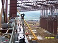
 Topographical work - NARA - 517584.jpg 3 000 × 1 840; 1,31 MB
-
 Topographical work - NARA - 517584.tif 3 000 × 1 840; 5,26 MB
-
 Topographical.jpg 750 × 410; 51 KB
-
 Topographie de burie.png 1 280 × 1 280; 816 KB
-
 Treppiede livello LG2, Galileo, 1960-1963, Firenze - Caserta, Museo Michelangelo.jpg 3 148 × 1 528; 255 KB
-

-
 TS by The sea.jpg 3 968 × 2 976; 3,75 MB
-
 Unidad 06 imagen 016.jpg 453 × 68; 11 KB
-
 View of the front of Tenby. Wellcome L0008802.jpg 1 830 × 1 126; 844 KB
-
 Xanthus, Lycia, a view of the plain. Lithograph by George Sc Wellcome L0021771.jpg 1 714 × 1 128; 862 KB
-
 Xanthus, Lycia, showing some of the ancient tombs. Lithograp Wellcome L0021769.jpg 1 612 × 1 174; 873 KB
-
 Xanthus, Lycia, women milling. Lithograph by George Scharf j Wellcome L0021770.jpg 1 666 × 1 118; 825 KB
-
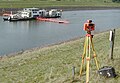
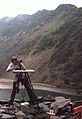 Surveyor Mapping Mountain Topography - geograph.org.uk - 104759.jpg 440 × 640; 59 KB
-
 Нагрудный знак.jpg 390 × 500; 69 KB
-
 दृश्य विधि.jpg 2 444 × 1 146; 713 KB
-
 삼각점.jpg 960 × 720; 297 KB


.jpg)


