Category:Tormarton
Aller à la navigation
Aller à la recherche
village britannique  | |||||
| Téléverser des médias | |||||
| Nature de l’élément | |||||
|---|---|---|---|---|---|
| Lieu | South Gloucestershire, Gloucestershire, Angleterre du Sud-Ouest, Angleterre | ||||
 | |||||
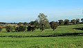
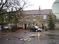
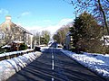
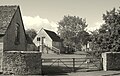
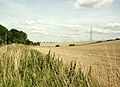
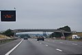
English: Tormarton is a village in South Gloucestershire, England. Its name comes from Thor Maer Tun meaning The settlement with the thorn (tree) on the boundary. It is one mile North-East of junction 18 of the M4 motorway, with the A46 road and close to the border between Wiltshire and South Gloucestershire. As of 2001 there were 144 households and the population was 348. A National Trail, the Cotswold Way passes through the village.[1] There is a church, a hotel, a pub and also a number of bed and breakfasts in the village.
- ↑ Exploring the Cotswald Way National trail. S. Glos Council. Retrieved on 30 June 2009.
Sous-catégories
Cette catégorie comprend 4 sous-catégories, dont les 4 ci-dessous.
Média dans la catégorie « Tormarton »
Cette catégorie comprend 461 fichiers, dont les 200 ci-dessous.
(page précédente) (page suivante)-
 'Live thou for England, we for England died' - geograph.org.uk - 5937199.jpg 1 704 × 2 304 ; 1,7 Mio
-
 'Younger' Tormarton skeleton, Bristol City Museum and Art Gallery.jpg 5 184 × 3 456 ; 5,4 Mio
-
 10 and 12 Marshfield Road, Tormarton, Badminton, Gloucestershire.jpg 2 518 × 1 888 ; 1,32 Mio
-
 10 Marshfield Rd, Tormarton, Gloucestershire 2012 - geograph.org.uk - 5288404.jpg 2 161 × 1 400 ; 729 kio
-
 2010 , A subtle hint, "Keep Out" sign - geograph.org.uk - 1964599.jpg 800 × 521 ; 162 kio
-
 2010 , A46 near Old Sodbury - geograph.org.uk - 2198380.jpg 1 600 × 1 279 ; 946 kio
-
 2010 , Acton Turville Road, Tormarton - geograph.org.uk - 1965602.jpg 800 × 655 ; 111 kio
-
 2010 , Approaching Tormarton on a minor road - geograph.org.uk - 1964641.jpg 800 × 565 ; 121 kio
-
 2010 , By-way to West Littleton - geograph.org.uk - 2050133.jpg 800 × 526 ; 219 kio
-
 2010 , Cattle feeder above the valley - geograph.org.uk - 2050118.jpg 800 × 549 ; 181 kio
-
 2010 , Crossroads on Church Road, Tormarton - geograph.org.uk - 1965592.jpg 800 × 404 ; 93 kio
-
 2010 , East on West Littleton Down - geograph.org.uk - 2004742.jpg 800 × 541 ; 113 kio
-
 2010 , Ebbdown Farm - geograph.org.uk - 2041985.jpg 800 × 612 ; 209 kio
-

-
 2010 , Fields and trees near The Warren - geograph.org.uk - 1964555.jpg 800 × 466 ; 85 kio
-
 2010 , It's behind you^ - geograph.org.uk - 2003297.jpg 800 × 654 ; 131 kio
-
 2010 , Minor road and horse chestnut in flower - geograph.org.uk - 1964572.jpg 800 × 614 ; 195 kio
-
 2010 , Minor road leaving Tormarton - geograph.org.uk - 1863953.jpg 800 × 606 ; 108 kio
-
 2010 , Minor road looking west toward Tormarton - geograph.org.uk - 1964584.jpg 800 × 665 ; 219 kio
-
 2010 , Minor road passing Tormarton - geograph.org.uk - 1863973.jpg 800 × 563 ; 243 kio
-
 2010 , Minor road to Acton Turville - geograph.org.uk - 1863866.jpg 800 × 573 ; 138 kio
-
 2010 , Minor road to Tormarton - geograph.org.uk - 1964530.jpg 800 × 518 ; 131 kio
-
 2010 , Part of Parks Farm - geograph.org.uk - 1863990.jpg 800 × 572 ; 168 kio
-
 2010 , Pasture and plantation east of the A46 - geograph.org.uk - 2201294.jpg 4 165 × 2 451 ; 2,81 Mio
-

-
 2010 , South east from Acton Turville Road - geograph.org.uk - 1964666.jpg 800 × 325 ; 54 kio
-
 2011 , Across a pasture to Newhouse Farm - geograph.org.uk - 2700779.jpg 3 796 × 2 141 ; 2,64 Mio
-
 2011 , B4040 heading east to Acton Turville - geograph.org.uk - 2702257.jpg 3 218 × 2 551 ; 4,03 Mio
-
 2011 , B4040 heading west toward the Old Sodbury crossroads - geograph.org.uk - 2700866.jpg 3 823 × 2 896 ; 4,41 Mio
-
 2011 , B4040 passing Newhouse Farm - geograph.org.uk - 2700853.jpg 4 414 × 2 823 ; 6,36 Mio
-
 2011 , B4040 passing Newhouse Farm Cottages - geograph.org.uk - 2700833.jpg 4 181 × 2 764 ; 3,92 Mio
-
 2011 , B4040 snakes past Newhouse Farm - geograph.org.uk - 2670365.jpg 3 949 × 2 883 ; 5,81 Mio
-
 2011 , East from the B4040 - geograph.org.uk - 2702290.jpg 4 102 × 2 479 ; 4,78 Mio
-
 2011 , East from the B4040 near Newhouse Farm - geograph.org.uk - 2670379.jpg 4 579 × 2 684 ; 4,62 Mio
-
 2011 , North east from the B4040 west of Acton Turville - geograph.org.uk - 2670409.jpg 3 783 × 2 764 ; 5,31 Mio
-
 A bare custodian - geograph.org.uk - 5936660.jpg 1 704 × 2 304 ; 1,47 Mio
-
 A big roof on a big barn - geograph.org.uk - 5935731.jpg 2 304 × 1 704 ; 1,78 Mio
-
 A Commonwealth grave - geograph.org.uk - 5937282.jpg 1 704 × 2 304 ; 1,71 Mio
-
 A dirty sign - geograph.org.uk - 5306176.jpg 2 304 × 1 704 ; 1,82 Mio
-
 A field of poppies beside the A46 - geograph.org.uk - 1374028.jpg 640 × 480 ; 93 kio
-

-
 A flowery tap - geograph.org.uk - 5935736.jpg 2 304 × 1 704 ; 1,75 Mio
-
 A former doorway - geograph.org.uk - 5306080.jpg 2 304 × 1 704 ; 1,44 Mio
-
 A game of socby^ - geograph.org.uk - 5936657.jpg 2 304 × 1 704 ; 1,76 Mio
-
 A large field west of Acton Turville - geograph.org.uk - 2506536.jpg 2 592 × 1 944 ; 1,61 Mio
-
 A long road to the end - geograph.org.uk - 5306075.jpg 2 304 × 1 704 ; 1,42 Mio
-
 A mark with daisies - geograph.org.uk - 5306172.jpg 1 704 × 2 304 ; 2,07 Mio
-
 A mileage marker on the A46, Bath Road - geograph.org.uk - 3454801.jpg 600 × 800 ; 166 kio
-
 A path around the back - geograph.org.uk - 5306089.jpg 1 704 × 2 304 ; 1,97 Mio
-
 A quiet village - geograph.org.uk - 5306203.jpg 1 704 × 2 304 ; 1,76 Mio
-
 A silent bell - geograph.org.uk - 5935809.jpg 1 704 × 2 304 ; 2,02 Mio
-
 A small and mossy spring - geograph.org.uk - 5306222.jpg 1 704 × 2 304 ; 2,02 Mio
-
 A softer sort of stone - geograph.org.uk - 5935735.jpg 2 304 × 1 704 ; 1,8 Mio
-

-
 A Spring trim - geograph.org.uk - 5306083.jpg 2 304 × 1 704 ; 1,62 Mio
-
 A state of disrepair - geograph.org.uk - 5936585.jpg 2 304 × 1 704 ; 1,58 Mio
-
 A surprise shady pool in the mid-summer downland - geograph.org.uk - 1374253.jpg 640 × 480 ; 157 kio
-
 A typical Cotswold stone wall - geograph.org.uk - 1374103.jpg 640 × 480 ; 95 kio
-
 A window on the bend - geograph.org.uk - 5306160.jpg 2 304 × 1 704 ; 1,67 Mio
-
 A46 along Long Plantation - geograph.org.uk - 4133990.jpg 1 600 × 1 145 ; 456 kio
-
 A46 at M4 junction 18 - geograph.org.uk - 5534281.jpg 640 × 427 ; 52 kio
-
 A46 looking north - geograph.org.uk - 1337121.jpg 640 × 500 ; 126 kio
-
 A46 near Tormarton - geograph.org.uk - 4133983.jpg 1 600 × 1 014 ; 547 kio
-
 Acton Turville Road - geograph.org.uk - 4882867.jpg 1 600 × 1 066 ; 339 kio
-
 Acton Turville Road - geograph.org.uk - 5226388.jpg 2 296 × 1 338 ; 782 kio
-

-
 Another G^T, Major^ - geograph.org.uk - 5936920.jpg 1 704 × 2 304 ; 1,28 Mio
-
 Aqueduct, Badminton Line, Acton Turville, Gloucestershire 2012 - geograph.org.uk - 5233333.jpg 2 146 × 1 403 ; 935 kio
-
 Arable field near Tormarton - geograph.org.uk - 5149415.jpg 800 × 600 ; 179 kio
-
 Arable land between Tormarton and Acton Turville - geograph.org.uk - 5226376.jpg 3 060 × 1 734 ; 1,34 Mio
-
 Arable land near Tormarton - geograph.org.uk - 5226304.jpg 3 072 × 1 766 ; 1,11 Mio
-
 Arable land near Tormarton - geograph.org.uk - 5226320.jpg 3 072 × 2 048 ; 1,6 Mio
-
 At the forefront of the village - geograph.org.uk - 5936934.jpg 2 304 × 1 704 ; 1,76 Mio
-
 Avenue of yews - geograph.org.uk - 5936634.jpg 1 704 × 2 304 ; 1,61 Mio
-
 Avenue to Old Hundred - geograph.org.uk - 5226174.jpg 2 011 × 2 937 ; 1,68 Mio
-
 B4040 at Newhouse Farm - geograph.org.uk - 214064.jpg 640 × 455 ; 30 kio
-
 B4040 near Newhouse Farm - geograph.org.uk - 6247479.jpg 800 × 600 ; 148 kio
-
 B4040 towards Acton Turville - geograph.org.uk - 4534774.jpg 800 × 621 ; 147 kio
-
 Barley field near Tormarton - geograph.org.uk - 5118427.jpg 6 000 × 4 000 ; 4,41 Mio
-
 Barns on Dodington estate - geograph.org.uk - 322811.jpg 640 × 480 ; 90 kio
-
 Bath Lodge, Dodington Park - geograph.org.uk - 4827484.jpg 640 × 471 ; 73 kio
-
 Beaufort Hunt Meet, The Green, West Littleton, Gloucestershire 2015 - geograph.org.uk - 5748323.jpg 2 806 × 1 824 ; 1,07 Mio
-
 Beaufort Hunt Meet, The Green, West Littleton, Gloucestershire 2015 - geograph.org.uk - 5748327.jpg 2 807 × 1 831 ; 1,33 Mio
-
 Beaufort Hunt, nr West Littleton, Gloucestershire 2008 - geograph.org.uk - 5749571.jpg 2 067 × 1 257 ; 1,03 Mio
-
 Beaufort Hunt, nr West Littleton, Gloucestershire 2015 - geograph.org.uk - 5748405.jpg 2 787 × 1 820 ; 1,19 Mio
-
 Beaufort Hunt, nr West Littleton, Gloucestershire 2015 - geograph.org.uk - 5748410.jpg 2 008 × 1 271 ; 635 kio
-
 Beaufort Hunt, nr West Littleton, Gloucestershire 2015 - geograph.org.uk - 5748415.jpg 2 815 × 1 800 ; 1,2 Mio
-
 Beaufort Hunt, nr West Littleton, Gloucestershire 2015 - geograph.org.uk - 5749582.jpg 2 289 × 1 290 ; 686 kio
-
 Beaufort Hunt, nr West Littleton, Gloucestershire 2015 - geograph.org.uk - 5749586.jpg 2 094 × 1 232 ; 507 kio
-
 Beaufort Hunt, West Littleton, Gloucestershire 1988 - geograph.org.uk - 5984369.jpg 2 402 × 1 602 ; 230 kio
-
 Beaufort Hunt, West Littleton, Gloucestershire 1988 - geograph.org.uk - 5984372.jpg 1 921 × 1 157 ; 276 kio
-
 Beaufort Hunt, West Littleton, Gloucestershire 2016 - geograph.org.uk - 5748269.jpg 1 675 × 1 082 ; 699 kio
-
 Benchmark in black - geograph.org.uk - 5935798.jpg 1 704 × 2 304 ; 1,79 Mio
-
 Benchmark off Marshfield Road - geograph.org.uk - 5935762.jpg 2 304 × 1 704 ; 1,71 Mio
-
 Benchmark off the footpath - geograph.org.uk - 5935768.jpg 2 304 × 1 704 ; 1,5 Mio
-
 Benchmark on Old Hundred Lane - geograph.org.uk - 5935787.jpg 2 304 × 1 704 ; 1,79 Mio
-
 Benchmark on the bend - geograph.org.uk - 5306162.jpg 2 304 × 1 704 ; 1,67 Mio
-
 Bennetts Barn, High Street, Tormarton, Badminton, Gloucestershire.jpg 2 739 × 1 815 ; 1,59 Mio
-
 Bridleway to Parks Farm - geograph.org.uk - 3855065.jpg 2 592 × 1 944 ; 1,37 Mio
-
 Bridleway to Tormarton - geograph.org.uk - 5123265.jpg 6 000 × 4 000 ; 5,77 Mio
-
 Bridleway towards Lower Lapdown Farm - geograph.org.uk - 5122894.jpg 6 000 × 4 000 ; 5,21 Mio
-

-

-
 Broadmead Brook, Shire Hill, nr West Kington, Wiltshire 2014 - geograph.org.uk - 5740309.jpg 3 872 × 2 592 ; 2,3 Mio
-
 Broadmead Brook, Shire Hill, nr West Kington, Wiltshire 2014 - geograph.org.uk - 5740361.jpg 3 872 × 2 592 ; 2,28 Mio
-
 Broadmead Brook, Shire Hill, nr West Kington, Wiltshire 2014 - geograph.org.uk - 5740366.jpg 3 872 × 2 592 ; 2,24 Mio
-
 Broadmead Brook, Shire Hill, nr West Kington, Wiltshire 2014 - geograph.org.uk - 5743362.jpg 3 872 × 2 592 ; 2,33 Mio
-
 Building a new dry stone wall - geograph.org.uk - 5476395.jpg 3 776 × 2 520 ; 3,19 Mio
-
 Bus Shelter, Tormarton, Gloucestershire 2012 - geograph.org.uk - 5745578.jpg 2 163 × 1 396 ; 882 kio
-
 Bus stop shelter, Church Road, Tormarton - geograph.org.uk - 5476456.jpg 3 776 × 2 520 ; 4,24 Mio
-
 By Beacon Lane Plantation - geograph.org.uk - 4506096.jpg 1 920 × 1 440 ; 1,04 Mio
-
 Camp Lane - geograph.org.uk - 5306922.jpg 2 304 × 1 704 ; 1,75 Mio
-
 Camp Lane crocuses - geograph.org.uk - 5306910.jpg 1 704 × 2 304 ; 2,01 Mio
-
 Cavendish Close - geograph.org.uk - 5937136.jpg 1 704 × 2 304 ; 1,48 Mio
-
 Cereal crop off the B4040 near Acton Turville - geograph.org.uk - 6247016.jpg 800 × 600 ; 139 kio
-
 Children's Playground, Tormarton, Gloucestershire 2012 - geograph.org.uk - 5745558.jpg 1 749 × 1 141 ; 736 kio
-
 Chimneys and Newhouse Cottage, High Street, Tormarton, Badminton, Gloucestershire.jpg 3 365 × 1 882 ; 1,85 Mio
-
 Church of St Mary Magdalene, Tormarton - geograph.org.uk - 5226270.jpg 3 072 × 2 048 ; 1,16 Mio
-
 Church of St Mary Magdalene, Tormarton - geograph.org.uk - 5476481.jpg 3 776 × 2 520 ; 4,02 Mio
-
 Church of St Mary Magdalene, Tormarton, Gloucestershire 2012 - geograph.org.uk - 5288406.jpg 1 749 × 1 141 ; 591 kio
-
 Church of St Mary Magdalene, Tormarton, Gloucestershire 2012 - geograph.org.uk - 5295178.jpg 2 202 × 1 400 ; 741 kio
-
 Church of St Mary Magdalene, Tormarton, Gloucestershire 2012 - geograph.org.uk - 5745629.jpg 1 381 × 2 079 ; 599 kio
-

-
 Church Road joins the High Street, Tormarton - geograph.org.uk - 3454983.jpg 800 × 600 ; 135 kio
-
 Church Road, Tormarton - geograph.org.uk - 3454981.jpg 800 × 600 ; 160 kio
-
 Church Road, Tormarton, Gloucestershire 2012 - geograph.org.uk - 5744717.jpg 2 240 × 1 488 ; 906 kio
-
 Church seat - geograph.org.uk - 5937253.jpg 2 304 × 1 704 ; 1,6 Mio
-
 Churchyard of St Mary Magdalene, Tormarton, Gloucestershire 2012 - geograph.org.uk - 5744726.jpg 1 988 × 1 291 ; 762 kio
-
 Churchyard paths, Tormarton - geograph.org.uk - 5226261.jpg 2 010 × 2 672 ; 1,62 Mio
-
 Cleared for viewing - geograph.org.uk - 5936671.jpg 2 304 × 1 704 ; 1,59 Mio
-

-
 Communications mast at junction 18 on the M4 - geograph.org.uk - 1373942.jpg 480 × 640 ; 57 kio
-
 Cornwall bound - geograph.org.uk - 4142809.jpg 4 000 × 2 664 ; 4,4 Mio
-
 Cotswold Way approaching A46 W of Tormarton - geograph.org.uk - 5622186.jpg 5 184 × 2 920 ; 2,01 Mio
-
 Cotswold Way, Tormarton - geograph.org.uk - 5226199.jpg 2 718 × 1 696 ; 962 kio
-
 Cotswold Way, western edge of Tormarton - geograph.org.uk - 5622184.jpg 5 184 × 2 920 ; 4,18 Mio
-
 Cottage on Acton Turville Road - geograph.org.uk - 4172022.jpg 1 024 × 768 ; 165 kio
-
 Cross Hands Hotel - geograph.org.uk - 86571.jpg 636 × 477 ; 160 kio
-
 Crossroads Near Tormarton - geograph.org.uk - 1152958.jpg 640 × 480 ; 103 kio
-
 Daffodils in the open - geograph.org.uk - 5306904.jpg 2 304 × 1 704 ; 1,71 Mio
-
 Dewpond - geograph.org.uk - 1196540.jpg 640 × 480 ; 113 kio
-
 Disappearing under the stones - geograph.org.uk - 5306941.jpg 1 704 × 2 304 ; 1,93 Mio
-
 Disconnected and seeded - geograph.org.uk - 5935745.jpg 2 304 × 1 704 ; 1,62 Mio
-
 Drive leading up to Ebbdown Farm, S of Tormarton - geograph.org.uk - 5614627.jpg 5 184 × 2 920 ; 5,07 Mio
-
 Dunsdown House, Dunsdown Lane, Tormarton, Gloucestershire.jpg 3 292 × 1 794 ; 2,24 Mio
-
 Early morning sunlight at St Mary's Church, Tormarton - geograph.org.uk - 5622180.jpg 5 184 × 2 920 ; 3,99 Mio
-
 East along the B4040 towards Acton Turville - geograph.org.uk - 4530751.jpg 800 × 607 ; 154 kio
-
 Edward VII postbox, Newhouse Farm - geograph.org.uk - 6247580.jpg 1 469 × 2 953 ; 1,11 Mio
-
 Electricity pylons near Tormarton - geograph.org.uk - 5149413.jpg 600 × 800 ; 113 kio
-
 Entrance to Sands Court - geograph.org.uk - 322484.jpg 629 × 418 ; 116 kio
-
 Farm Building, The Street, Tormarton, Gloucestershire 2012 - geograph.org.uk - 5745595.jpg 2 172 × 1 378 ; 757 kio
-
 Farm buildings off Norley Lane, Tormarton - geograph.org.uk - 1452348.jpg 640 × 483 ; 113 kio
-
 Farmland between Tormarton and Acton Turville - geograph.org.uk - 5226471.jpg 3 056 × 1 797 ; 1,17 Mio
-
 Farmland by Newhouse Farm - geograph.org.uk - 5230733.jpg 2 731 × 1 314 ; 557 kio
-
 Farmland by Tormarton - geograph.org.uk - 3662214.jpg 2 592 × 1 944 ; 1,08 Mio
-
 Farmland near Tormarton - geograph.org.uk - 5660566.jpg 2 146 × 988 ; 266 kio
-
 Farmland north of the A4039 - geograph.org.uk - 5591311.jpg 640 × 427 ; 103 kio
-
 Farmland ^ air shaft tower on Sodbury Railway Tunnel - geograph.org.uk - 5622267.jpg 5 184 × 2 920 ; 5,9 Mio
-
 Field at Old Warren - geograph.org.uk - 5226545.jpg 2 888 × 1 769 ; 1,25 Mio
-
 Field by Norley Lane - geograph.org.uk - 5226121.jpg 3 072 × 2 048 ; 1,49 Mio
-
 Field of cut grass near Tormarton - geograph.org.uk - 5118398.jpg 6 000 × 4 000 ; 4,79 Mio
-
 Field of oats near Kington Down Farm - geograph.org.uk - 1449971.jpg 640 × 463 ; 158 kio
-
 Field south of the B4039 - geograph.org.uk - 5591309.jpg 640 × 427 ; 98 kio
-
 Field track near Acton Turville - geograph.org.uk - 4530760.jpg 800 × 498 ; 142 kio
-
 Field with dead-looking crops - geograph.org.uk - 5118392.jpg 6 000 × 4 000 ; 6,36 Mio
-
 Fields leading up to Littleton Wood Barn - geograph.org.uk - 2614303.jpg 3 648 × 2 736 ; 1,09 Mio
-
 Fields north of Tormarton - geograph.org.uk - 3443366.jpg 2 592 × 1 944 ; 1,64 Mio
-
 Fields on West Littleton Down - geograph.org.uk - 5123249.jpg 6 000 × 4 000 ; 5,96 Mio
-
 Footbridge over the M4 - geograph.org.uk - 3661042.jpg 640 × 430 ; 35 kio
-
 Footpath and farm bridge over M4 south of Parks Farm - geograph.org.uk - 5430613.jpg 1 600 × 1 198 ; 698 kio
-
 Footpath from Tormarton - geograph.org.uk - 5118450.jpg 5 625 × 3 750 ; 2,84 Mio
-
 Footpath to Tormarton - geograph.org.uk - 5118379.jpg 6 000 × 4 000 ; 6,07 Mio
-
 Fresh air and a seat - geograph.org.uk - 5935450.jpg 1 704 × 2 304 ; 1,63 Mio
-
 Freshly turned field by Warren Barn - geograph.org.uk - 1745912.jpg 640 × 480 ; 90 kio
-
 Gate to field by Sheepcot Barn - geograph.org.uk - 1745901.jpg 640 × 480 ; 76 kio
-
 Gateway into a cornfield at Tolldown - geograph.org.uk - 1374140.jpg 640 × 480 ; 99 kio
-
 Gateway to West Littleton Down - geograph.org.uk - 1374219.jpg 640 × 480 ; 134 kio
-
 Glebe Farmhouse - geograph.org.uk - 4172017.jpg 1 024 × 768 ; 216 kio
-
 Glebe Farmhouse, Tormarton, Gloucestershire 2012 - geograph.org.uk - 5744483.jpg 2 174 × 1 375 ; 630 kio
-
 Going west. - geograph.org.uk - 4142819.jpg 4 000 × 2 664 ; 3,2 Mio
-
 Grange Farm Cottage, High Street, Tormarton, Badminton, Gloucestershire.jpg 2 539 × 1 904 ; 1,29 Mio
-
 Grass and flowers - geograph.org.uk - 6191400.jpg 4 032 × 3 024 ; 3,3 Mio
-
 Grazing and woodland near Newhouse Farm - geograph.org.uk - 6247023.jpg 800 × 600 ; 127 kio
-
 Grazing near Acton Turville - geograph.org.uk - 6247014.jpg 800 × 600 ; 121 kio
-
 Green stone - geograph.org.uk - 5306092.jpg 1 704 × 2 304 ; 2,05 Mio
-
 Greeting the worshippers - geograph.org.uk - 5937214.jpg 1 704 × 2 304 ; 1,72 Mio
-
 Harvested field by Beacon Lane - geograph.org.uk - 5123278.jpg 6 000 × 4 000 ; 5,56 Mio
-
 Harvested field on West Littleton Down - geograph.org.uk - 5123236.jpg 6 000 × 4 000 ; 5,92 Mio
-
 Harvested field south east of Tormarton - geograph.org.uk - 1450342.jpg 640 × 456 ; 160 kio
-
 High Street, Tormarton - geograph.org.uk - 1451391.jpg 640 × 505 ; 115 kio
-
 High Street, Tormarton from the east - geograph.org.uk - 1451510.jpg 640 × 498 ; 130 kio
-
 Highways Agency Salt store - geograph.org.uk - 1373957.jpg 640 × 480 ; 57 kio
-
 Highways Agency sign for a picnic site - geograph.org.uk - 1374039.jpg 640 × 480 ; 91 kio
-
 House and barns, Tormarton - geograph.org.uk - 5226184.jpg 3 056 × 1 844 ; 1,13 Mio
-
 House, The Street, Tormarton, Gloucestershire 2012 - geograph.org.uk - 5745564.jpg 2 116 × 1 387 ; 700 kio
-
 House, The Street, Tormarton, Gloucestershire 2012 - geograph.org.uk - 5745581.jpg 2 107 × 1 366 ; 765 kio
-
 Houses in Tormarton - geograph.org.uk - 5118405.jpg 6 000 × 4 000 ; 3,8 Mio
-
 Houses on High Street, Tormarton - geograph.org.uk - 1452376.jpg 640 × 507 ; 121 kio
-
 Houses on Marshfield Road, Tormarton - geograph.org.uk - 3455102.jpg 800 × 600 ; 145 kio
-
 Houses, The Street, Tormarton, Gloucestershire 2012 - geograph.org.uk - 5745570.jpg 2 154 × 1 357 ; 697 kio


