Category:Tranent
Aller à la navigation
Aller à la recherche
English: Tranent is a town in East Lothian, Scotland. It is close to the A1 road and approximately east of Edinburgh. It is one of the oldest towns in East Lothian, and built on a gentle slope, about 300 feet above sea level.
Gàidhlig: Tha Tranant ann an Lodainn an Ear. 'S e seo na co-chomharran aige: 55° 56′ 0″ Tuath agus 2° 57′ 0″ Iar.
Italiano: Tranent è una piccola cittadina scozzese situata nell'area amministrativa dell'East Lothian. Si trova nelle vicinanze della strada A1 e approssimativamente a 11 miglia da Edimburgo.
localité britannique  | |||||
| Téléverser des médias | |||||
| Nature de l’élément |
| ||||
|---|---|---|---|---|---|
| Lieu |
| ||||
| Population |
| ||||
 | |||||
Sous-catégories
Cette catégorie comprend 5 sous-catégories, dont les 5 ci-dessous.
T
- Tranent Co-operative Society (2 F)
- Tranent Parish Church (6 F)
- Tranent War Memorial (5 F)
Média dans la catégorie « Tranent »
Cette catégorie comprend 90 fichiers, dont les 90 ci-dessous.
-
 'Massacre of Tranent' memorial in Civic Square, Tranent, East Lothian.jpg 1 200 × 1 600 ; 1,37 Mio
-
 121 Church Street, Tranent.jpg 8 000 × 6 000 ; 13,62 Mio
-
 Approaching Tranent - geograph.org.uk - 840252.jpg 640 × 480 ; 49 kio
-
 Barley field at Myles Farm near Tranent - geograph.org.uk - 1453368.jpg 640 × 480 ; 42 kio
-
 Battle of Prestonpans viewpoint 2017-05-28.jpg 7 360 × 4 912 ; 8,43 Mio
-
 Bridge at the top of the Heugh - geograph.org.uk - 962131.jpg 640 × 480 ; 118 kio
-
 Building plot - geograph.org.uk - 962137.jpg 640 × 359 ; 63 kio
-
 Bus in Haddington Road, Tranent, 26 January 2014.jpg 640 × 480 ; 261 kio
-
 Buxley Farm - geograph.org.uk - 845697.jpg 640 × 480 ; 56 kio
-
 Thomas Cadell VC.JPG 1 200 × 1 600 ; 822 kio
-
 Childrens' playpark in the snow - geograph.org.uk - 1650997.jpg 640 × 480 ; 80 kio
-
 CivicSquareMemorial.jpg 498 × 200 ; 70 kio
-
 Clock Tower and War Memorial, Tranent (geograph 6123999).jpg 1 024 × 768 ; 194 kio
-
 Coalgate Avenue, Tranent - geograph.org.uk - 1301393.jpg 640 × 480 ; 78 kio
-
 Cottages at New Winton - geograph.org.uk - 840249.jpg 640 × 480 ; 78 kio
-
 Doocot at Tranent Kirk.jpg 480 × 640 ; 172 kio
-
 Fields and sheds at Tranent - geograph.org.uk - 1301219.jpg 640 × 480 ; 68 kio
-
 Former school building, Sanderson's Wynd (geograph 6515685).jpg 1 024 × 768 ; 255 kio
-
 Fowler Street, Tranent - geograph.org.uk - 1301304.jpg 640 × 480 ; 79 kio
-
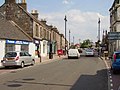 High Street, Tranent - geograph.org.uk - 208874.jpg 640 × 480 ; 71 kio
-
 Kingdom Hall, Tranent - geograph.org.uk - 3541403.jpg 3 210 × 2 374 ; 2,19 Mio
-
 Masonic lodge, Tranent - geograph.org.uk - 410647.jpg 480 × 640 ; 75 kio
-
 Meeting House Drive - geograph.org.uk - 1301291.jpg 640 × 480 ; 70 kio
-
 Muirpark Road - geograph.org.uk - 1651012.jpg 640 × 480 ; 96 kio
-
 Muirpark Road, Tranent - geograph.org.uk - 845711.jpg 640 × 480 ; 56 kio
-
 Mural, Tranent - geograph.org.uk - 1742117.jpg 480 × 640 ; 94 kio
-
 Old and New Tranent - geograph.org.uk - 531901.jpg 640 × 480 ; 64 kio
-
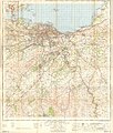 Ordnance Survey One-Inch Map Sheet 62 Edinburgh.jpg 7 460 × 8 801 ; 9,23 Mio
-
 Ormiston Road - geograph.org.uk - 410657.jpg 638 × 458 ; 54 kio
-
 R Reilly Service Centre - geograph.org.uk - 1742113.jpg 640 × 480 ; 59 kio
-
 Ross High School from Meeting House Drive - geograph.org.uk - 1301293.jpg 640 × 480 ; 61 kio
-
 Ruins of seton mill 02.jpg 3 456 × 2 304 ; 4,11 Mio
-
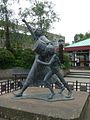
 Sculpture - geograph.org.uk - 720148.jpg 480 × 640 ; 156 kio
-
 Seton Lodge, Tranent 01.jpg 3 888 × 2 592 ; 4,38 Mio
-
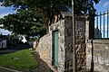 Seton Lodge, Tranent 02 garden wall and doorway.jpg 3 888 × 2 592 ; 5,28 Mio
-
 Seton Lodge, Tranent 03, detail of plaque above door.jpg 2 592 × 3 888 ; 4,81 Mio
-
 Seton Lodge, Tranent 04.jpg 3 888 × 2 592 ; 4,84 Mio
-
 St Martin of Tours Roman Catholic Church, Tranent, East Lothian, Scotland.jpg 1 536 × 864 ; 109 kio
-
 The back of Civic Square - geograph.org.uk - 649722.jpg 640 × 480 ; 70 kio
-
 The edge of Tranent - geograph.org.uk - 1301384.jpg 640 × 480 ; 87 kio
-
 The Heugh - geograph.org.uk - 962134.jpg 640 × 480 ; 133 kio
-
 The Kingdom Hall. - geograph.org.uk - 971519.jpg 640 × 480 ; 78 kio
-
 Tranent - geograph.org.uk - 1739036.jpg 640 × 480 ; 75 kio
-
 Tranent civic sq.jpg 480 × 640 ; 85 kio
-
 Tranent Cooperative millinery shop 1943.jpg 640 × 480 ; 67 kio
-
 Tranent Cooperative Report March 1920.jpg 400 × 321 ; 26 kio
-
 Tranent from the air (geograph 5837698).jpg 1 024 × 768 ; 363 kio
-
 Tranent Tower (2).jpg 2 592 × 3 888 ; 3,2 Mio
-
 Tranent Tower.jpg 640 × 480 ; 96 kio
-
 Tranent town clock - geograph.org.uk - 1935210.jpg 480 × 640 ; 53 kio
-
 Tranent, 10 Fowler Street.jpg 8 000 × 6 000 ; 9,68 Mio
-
 Tranent, 110 Church Street.jpg 8 000 × 6 000 ; 12,37 Mio
-
 Tranent, Church Street, Former Manse.jpg 8 000 × 6 000 ; 14,87 Mio
-
 Tranent, Church Street, Parish Church Hall.jpg 8 000 × 6 000 ; 17,31 Mio
-
 Tranent, East Lothian - The High Street - geograph.org.uk - 672146.jpg 640 × 480 ; 78 kio
-
 Tranent-civic-square.jpg 450 × 338 ; 50 kio
-
 TranentWallyfordMacmerry.png 1 084 × 700 ; 35 kio
-
 Walk Plantation - geograph.org.uk - 1135948.jpg 640 × 480 ; 148 kio
-
 Water Boatman - Corixidae - Flickr - S. Rae.jpg 720 × 644 ; 164 kio
-
 West Windygoul - geograph.org.uk - 602314.jpg 640 × 480 ; 62 kio
-
 Windygoul - geograph.org.uk - 629442.jpg 640 × 480 ; 52 kio
-
 Windygoul - geograph.org.uk - 629446.jpg 527 × 640 ; 72 kio
-
 Windygoul - geograph.org.uk - 629448.jpg 640 × 471 ; 60 kio
-
 A198-A1 junction - geograph.org.uk - 410642.jpg 640 × 480 ; 40 kio
-
 Advancing Tranent - geograph.org.uk - 531205.jpg 640 × 480 ; 87 kio
-
 Arable land - geograph.org.uk - 164372.jpg 640 × 453 ; 81 kio
-
 Barley field, Buxley - geograph.org.uk - 19736.jpg 640 × 480 ; 90 kio
-
 Carlaverock - geograph.org.uk - 19733.jpg 640 × 467 ; 40 kio
-
 Colliery waste. - geograph.org.uk - 19702.jpg 640 × 460 ; 86 kio
-
 Edge of Tranent - geograph.org.uk - 410658.jpg 640 × 480 ; 69 kio
-
 Edge of Tranent - geograph.org.uk - 410836.jpg 640 × 480 ; 67 kio
-
 Fleets access road - geograph.org.uk - 602363.jpg 640 × 480 ; 73 kio
-
 Fleets Industrial Estate - geograph.org.uk - 602324.jpg 640 × 480 ; 73 kio
-
 Flytipping, Macmerry. - geograph.org.uk - 53645.jpg 640 × 480 ; 75 kio
-
 Inveresk Labs - geograph.org.uk - 19731.jpg 640 × 480 ; 69 kio
-
 Kingslaw - geograph.org.uk - 53651.jpg 640 × 480 ; 47 kio
-
 Kingslaw - geograph.org.uk - 53652.jpg 640 × 480 ; 80 kio
-
 Macmerry - geograph.org.uk - 53625.jpg 640 × 480 ; 95 kio
-
 Meadow - geograph.org.uk - 19735.jpg 640 × 464 ; 74 kio
-
 Mortar silos, Windygoul - geograph.org.uk - 629444.jpg 640 × 480 ; 59 kio
-
 Muir Park, Tranent - geograph.org.uk - 531905.jpg 640 × 480 ; 65 kio
-
 Newly planted field, near Tranent. - geograph.org.uk - 53647.jpg 640 × 480 ; 39 kio
-
 Next building site, West Windygoul - geograph.org.uk - 629453.jpg 640 × 480 ; 56 kio
-
 Parklands - geograph.org.uk - 629450.jpg 640 × 480 ; 59 kio
-
 Path, Pylon and Prestonpans, from Tranent - geograph.org.uk - 316409.jpg 640 × 480 ; 91 kio
-
 Pylonland - geograph.org.uk - 602308.jpg 640 × 480 ; 49 kio
-
 Roadworks suspended, Macmerry. - geograph.org.uk - 96859.jpg 640 × 480 ; 141 kio
-
 Scrubland, West Windygoul - geograph.org.uk - 629454.jpg 640 × 480 ; 99 kio
-
 The Jet Filling Station at Post Road, Tranent - geograph.org.uk - 316387.jpg 640 × 480 ; 72 kio
-
 The old A1 outside Tranent - geograph.org.uk - 602302.jpg 640 × 480 ; 57 kio


.jpg)


.jpg)


.jpg)
.jpg)


