Category:Tsumagoi, Gunma
Zur Navigation springen
Zur Suche springen
Ort in der Präfektur Gunma, Japan     | |||||
| Medium hochladen | |||||
| Ist ein(e) | |||||
|---|---|---|---|---|---|
| Ort |
| ||||
| Rechtsform |
| ||||
| Datum der Gründung, Erstellung, Entstehung, Erbauung |
| ||||
| Einwohnerzahl |
| ||||
| Fläche |
| ||||
| offizielle Website | |||||
 | |||||
한국어: 쓰마고이 촌
Русский: Цумагои
Unterkategorien
Es werden 22 von insgesamt 22 Unterkategorien in dieser Kategorie angezeigt:
In Klammern die Anzahl der enthaltenen Kategorien (K), Seiten (S), Dateien (D)
1
A
F
- Fukurogura Station (3 D)
K
- Mount Kakuma (3 D)
- Kazawa Snow Area (3 D)
M
- Manza Onsen Ski Resort (5 D)
- Manza Prince Hotel (4 D)
- Manza-Kazawaguchi Station (19 D)
O
- Ogushi Sulfur Mine (5 D)
- Omae Station (16 D)
- Mount Omeshi (1 D)
- Omote Manza Snow Park (2 D)
- Onioshidashien (16 D)
- Ozasa Sekisho (2 D)
P
- Palcall Tsumagoi Ski Resort (3 D)
T
- Tsumagoi History Museum (2 D)
Y
Medien in der Kategorie „Tsumagoi, Gunma“
Folgende 104 Dateien sind in dieser Kategorie, von 104 insgesamt.
-
 Tsumagoi in Gunma Prefecture Ja.svg 501 × 523; 11 KB
-
 A-Coop at Tsumagoi, Gunma.jpg 2.854 × 2.141; 906 KB
-

-
 Asama large area farming route Tsumagoi Japan.JPG 3.072 × 2.304; 1,63 MB
-
 Asama large area farming route Tsumagoi Japan1210.JPG 3.308 × 2.352; 4,42 MB
-
 Asama large area farming route Tsumagoi Japan12101.JPG 3.012 × 2.516; 1,17 MB
-
 Asama Test Course ckt-75-11 c12 31.jpg 2.824 × 1.883; 1,03 MB
-
 ASAMA Volcano Museum 2017-04.jpg 4.608 × 3.456; 5 MB
-
 Emblem of Tsumagoi, Gunma.jpg 236 × 224; 14 KB
-
 Emblem of Tsumagoi, Gunma.svg 200 × 200; 1 KB
-
 Flag of Tsumagoi Gunma.JPG 469 × 342; 21 KB
-
 Flag of Tsumagoi, Gunma (no text).svg 600 × 400; 1 KB
-
 Flag of Tsumagoi, Gunma.svg 600 × 400; 8 KB
-
 Gunma Bank Tsumagoi branch.jpg 3.264 × 2.448; 1,44 MB
-
 Gunma Mirai Credit Union Tsumagoi branch.jpg 2.717 × 2.038; 1,07 MB
-

-

-
-
 Imai hydroelectric power station weir.jpg 4.258 × 3.156; 2,28 MB
-
 Imai hydroelectric power station.jpg 3.237 × 2.426; 1,35 MB
-
 JA Tsumagoi-mura.jpg 2.528 × 1.896; 781 KB
-
 Jr-kazawa-taikijo.JPG 562 × 422; 67 KB
-
 Kanbara, Tsumagoi, Agatsuma District, Gunma Prefecture 377-1524, Japan - panoramio (1).jpg 1.536 × 2.048; 1.016 KB
-
 Kanbara, Tsumagoi, Agatsuma District, Gunma Prefecture 377-1524, Japan - panoramio.jpg 2.048 × 1.536; 1,07 MB
-
 KASAWAONSEN.JPG 2.048 × 1.536; 374 KB
-
 Kazawa Dam survey.jpg 1.371 × 1.828; 358 KB
-
 Kazawa hydroelectric power station.jpg 3.539 × 2.656; 1,28 MB
-
 Ken H. IMG 0314 1600 (8698210015).jpg 1.600 × 1.200; 1,84 MB
-
 Kusakaru-agatsuma-br.JPG 640 × 480; 125 KB
-
 Manza-highway-autumn.jpg 5.472 × 3.648; 8,24 MB
-
 Manza-Highway-Manza-Ent.JPG 4.608 × 3.456; 3,64 MB
-
 Manza-Highway.JPG 4.608 × 3.456; 2,88 MB
-
 Mihara Post office(Gunma).jpg 2.648 × 1.986; 893 KB
-
 Mount Azumaya (SSE side) - panoramio.jpg 2.007 × 1.338; 1,79 MB
-
 Mount Nishi Kagonoto.jpg 6.000 × 4.000; 9,08 MB
-
 Mt. Kagonoto.JPG 4.416 × 3.312; 5,35 MB
-
 Mt. Nishi Kagonoto from the Summer mountain lift at Yunomaru Plateau.jpg 6.000 × 4.000; 9,42 MB
-
 Nakai Jubei monument.jpg 4.730 × 3.153; 1,16 MB
-
 Omae chuzaisyo (tsumagoi,gunma).jpg 2.556 × 1.916; 917 KB
-
 Ozasa, Tsumagoi, Agatsuma District, Gunma Prefecture 377-1613, Japan - panoramio (1).jpg 2.048 × 1.536; 486 KB
-
 Ozasa, Tsumagoi, Agatsuma District, Gunma Prefecture 377-1613, Japan - panoramio (2).jpg 2.048 × 1.536; 327 KB
-
 Ozasa, Tsumagoi, Agatsuma District, Gunma Prefecture 377-1613, Japan - panoramio (3).jpg 2.048 × 1.536; 419 KB
-
 Ozasa, Tsumagoi, Agatsuma District, Gunma Prefecture 377-1613, Japan - panoramio.jpg 2.048 × 1.536; 443 KB
-
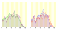 Population distribution of Tsumagoi, Gunma, Japan.svg 512 × 256; 22 KB
-
 R144-2020-053.jpg 1.859 × 1.044; 553 KB
-
 Saikubo hydroelectric power station weir.jpg 4.320 × 3.240; 2,2 MB
-
 Saikubo hydroelectric power station.jpg 4.320 × 3.240; 2,43 MB
-
 Seibu elementary school in Tsumagoi, Gunma-2.jpg 3.260 × 2.445; 1,19 MB
-
 Seibu elementary school in Tsumagoi, Gunma.jpg 3.003 × 2.252; 1,28 MB
-
 Seibukogen-manza-highway.JPG 562 × 408; 88 KB
-

-
 Tashiro, Tsumagoi, Agatsuma District, Gunma Prefecture 377-1614, Japan - panoramio (2).jpg 2.048 × 1.536; 1,06 MB
-
 Torii Pass (Gunma - Nagano) monument.jpg 1.979 × 1.484; 778 KB
-
 Torii Pass (Gunma - Nagano).jpg 4.608 × 3.456; 1,66 MB
-
 Tsuimakoi Village office 01.jpg 4.032 × 3.024; 1,91 MB
-
 Tsumagoi banner.jpg 2.048 × 292; 136 KB
-
 Tsumagoi baragionsen kohannoyu.jpg 1.406 × 937; 414 KB
-
 Tsumagoi Cabbage&Asamayama.JPG 2.560 × 1.920; 1,57 MB
-
 Tsumagoi High School.JPG 2.816 × 1.880; 3,29 MB
-
 Tsumagoi Onsen Tsumagoi-kan.jpg 2.734 × 2.050; 1.017 KB
-
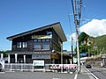 Tsumagoi tourist information center.jpg 2.907 × 2.179; 1,11 MB
-
 Tsumagoi village office.JPG 3.648 × 2.052; 2,8 MB
-
 Tumagoi aisaino oka.jpg 3.260 × 2.768; 5,13 MB
-
 Tumagoi aisainooka sainn.JPG 4.000 × 3.000; 2,62 MB
-
 Ushi-Ike.jpg 5.472 × 3.648; 9,58 MB
-
 Ōmae Station train 03.jpg 4.032 × 3.024; 2,39 MB
-
 つまごいパノラマライン - panoramio (1).jpg 2.048 × 1.152; 445 KB
-
 つまごいパノラマライン - panoramio (2).jpg 2.048 × 1.152; 460 KB
-
 つまごいパノラマライン - panoramio (3).jpg 2.048 × 1.152; 796 KB
-
 つまごいパノラマライン - panoramio (4).jpg 2.048 × 1.152; 370 KB
-
 つまごいパノラマライン - panoramio.jpg 2.048 × 1.152; 365 KB
-
 メロディーライン - panoramio.jpg 2.048 × 1.152; 553 KB
-
 万座・鹿沢口駅付近の吾妻川 - panoramio (1).jpg 4.386 × 2.920; 1,43 MB
-
 万座・鹿沢口駅付近の吾妻川 - panoramio.jpg 4.386 × 2.920; 1,45 MB
-
 万座高原ホテル - panoramio.jpg 3.648 × 2.736; 1,63 MB
-
 北軽井沢 - panoramio (1).jpg 1.600 × 900; 323 KB
-
 吾妻川 - panoramio (1).jpg 4.752 × 3.168; 2,68 MB
-
 吾妻川 - panoramio.jpg 4.752 × 3.168; 1,9 MB
-
 国道144号線 - panoramio.jpg 1.600 × 900; 250 KB
-
 国道292 渋峠 20130708 - panoramio.jpg 2.736 × 1.824; 3,02 MB
-
 国道292号線の夕日の丘から見た万座山方面 左奥は北アルプス Pcs34560 00165.jpg 5.782 × 3.946; 3,88 MB
-
 嬬恋パノラマライン・北ルート 20130708 - panoramio.jpg 2.736 × 1.824; 3,37 MB
-
 嬬恋村 キャベツ畑 20130708 - panoramio.jpg 2.736 × 1.824; 3,66 MB
-
 嬬恋村大前 - panoramio (1).jpg 2.048 × 1.152; 504 KB
-
 嬬恋村大前 - panoramio (2).jpg 2.048 × 1.152; 621 KB
-
 嬬恋村大前 - panoramio (3).jpg 2.048 × 1.152; 291 KB
-
 嬬恋村大前 - panoramio.jpg 2.048 × 1.151; 414 KB
-
 嬬恋東小学校全景.jpg 3.648 × 2.492; 3,53 MB
-
 小串の隧道跡 - panoramio.jpg 1.926 × 2.560; 1,93 MB
-
 山の駅笹見平 - panoramio.jpg 1.600 × 900; 341 KB
-
 志賀草津道路 - panoramio (13).jpg 1.600 × 900; 428 KB
-
 志賀草津道路 - panoramio (14).jpg 1.600 × 900; 456 KB
-
 浅間山 - panoramio - alonfloc (1).jpg 3.648 × 2.736; 1,56 MB
-
 浅間山~浅間高原牧場より3 - panoramio.jpg 1.024 × 683; 222 KB
-
 田代湖 - panoramio.jpg 1.600 × 900; 253 KB
-
 県道94号線 - panoramio (1).jpg 2.048 × 1.152; 529 KB
-
 県道94号線 - panoramio.jpg 2.048 × 1.152; 901 KB
-
 私をスキーに連れてって.jpg 366 × 220; 21 KB
-
 草軽鉄道跡 - panoramio (1).jpg 1.600 × 900; 259 KB
-
 鎌原観音堂(1).jpg 3.264 × 2.448; 3,24 MB
-
 鎌原観音堂.jpg 480 × 854; 97 KB
-
 霧の池.JPG 5.472 × 3.648; 4,19 MB
-
 鬼押ハイウェイ - panoramio.jpg 2.592 × 1.456; 1,12 MB
-
 鳥居峠 - panoramio.jpg 1.600 × 900; 286 KB


.svg)


.jpg)


.jpg)


.jpg)
_-_panoramio.jpg)


.jpg)
.jpg)
.jpg)
.jpg)


.jpg)
.jpg)
_monument.jpg)
.jpg)


.jpg)
.jpg)
.jpg)
.jpg)


.jpg)


.jpg)
.jpg)


.jpg)
.jpg)
.jpg)


.jpg)
.jpg)
.jpg)


.jpg)


.jpg)
.jpg)


.jpg)
.jpg)
.jpg)