Category:Twemlow
Vai alla navigazione
Vai alla ricerca
English: Twemlow is a civil parish, containing the village of Twemlow Green in the unitary authority of Cheshire East and the ceremonial county of Cheshire, England. According to the 2001 Official UK Census, the population of the entire civil parish was 168.
civil parish in Cheshire, United Kingdom  | |||||
| Carica un file multimediale | |||||
| Istanza di | |||||
|---|---|---|---|---|---|
| Luogo | Cheshire East, Cheshire, Nord Ovest dell'Inghilterra, Inghilterra | ||||
 | |||||
Sottocategorie
Questa categoria contiene un'unica sottocategoria, indicata di seguito.
T
- Twemlow Viaduct (16 F)
File nella categoria "Twemlow"
Questa categoria contiene 71 file, indicati di seguito, su un totale di 71.
-
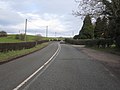
 A535 at Twemlow Green - geograph.org.uk - 2771799.jpg 640 × 480; 83 KB
-
 A535 Macclesfield Road Holmes Chapel - geograph.org.uk - 2817995.jpg 4 000 × 3 000; 4,42 MB
-
 A535 Macclesfield Road near Saltersford Farm, Twemlow Green - geograph.org.uk - 2817977.jpg 4 000 × 3 000; 2,92 MB
-
 A535 Macclesfield Road, Twemlow Green - geograph.org.uk - 2817967.jpg 4 000 × 3 000; 3,01 MB
-
 Bank Farm - geograph.org.uk - 2942003.jpg 4 000 × 3 000; 4,03 MB
-
 Bank Farm Conversions - revisited - geograph.org.uk - 5493717.jpg 1 600 × 1 200; 602 KB
-
 Bidlea Dairy, Twemlow Lane - geograph.org.uk - 6126637.jpg 1 600 × 1 202; 357 KB
-
 Blueslate Farm, Twemlow Lane - geograph.org.uk - 2771823.jpg 640 × 480; 56 KB
-
 Captain Egerton Leigh and his wife Lady Elizabeth.jpg 2 142 × 1 426; 604 KB
-
 Cattle troughs in a muddy pasture field - geograph.org.uk - 3263173.jpg 1 024 × 768; 172 KB
-

-

-
 Cheshire landscape - geograph.org.uk - 3829741.jpg 640 × 430; 33 KB
-
 Cottage at the corner, Twemlow Green - geograph.org.uk - 2771801.jpg 640 × 480; 71 KB
-
 Cyclists on Twemlow Lane - geograph.org.uk - 3263178.jpg 1 024 × 768; 124 KB
-
 Farm track north of Twemlow Lane - geograph.org.uk - 3263168.jpg 1 024 × 768; 128 KB
-

-
 Farmland near Goostrey Station - geograph.org.uk - 3345864.jpg 640 × 517; 44 KB
-
 Farmland near Saltersford Farm - geograph.org.uk - 3345866.jpg 800 × 589; 52 KB
-
 Farmland north of Twemlow Lane - geograph.org.uk - 3263156.jpg 1 024 × 768; 156 KB
-
 Fenceline - geograph.org.uk - 5341693.jpg 640 × 426; 52 KB
-
 Field entrance on the south side of Twemlow Lane - geograph.org.uk - 3263188.jpg 1 024 × 768; 132 KB
-
 Forty Acre Lane at A535 junction - geograph.org.uk - 2352679.jpg 640 × 480; 93 KB
-
 FP to Blackyard farm. - geograph.org.uk - 2437501.jpg 640 × 480; 124 KB
-

-
 Jodrell Bank from Twemlow Lane - geograph.org.uk - 6126646.jpg 1 600 × 1 201; 346 KB
-
 Junction at Twemlow Green - geograph.org.uk - 4462327.jpg 4 320 × 3 240; 4,33 MB
-
 Lane near Twemlow Green - geograph.org.uk - 493155.jpg 480 × 640; 175 KB
-
 Long straight on Twemlow Lane - geograph.org.uk - 2771825.jpg 640 × 480; 58 KB
-

-
 Map Jodrell Hall 1875.jpg 4 000 × 3 159; 2,29 MB
-

-
 Outnumbered by crows - geograph.org.uk - 3263208.jpg 1 024 × 768; 218 KB
-
 Pasture field south of Twemlow Lane - geograph.org.uk - 3263202.jpg 1 024 × 768; 166 KB
-
 Ploughed field near Goostrey - geograph.org.uk - 4925492.jpg 1 024 × 768; 135 KB
-
 Pond at Twemlow - geograph.org.uk - 6126651.jpg 1 600 × 1 202; 994 KB
-
 Railway at Twemlow Green - geograph.org.uk - 215053.jpg 640 × 480; 58 KB
-
 Roadside trees, Twemlow Lane - geograph.org.uk - 3263215.jpg 1 024 × 768; 140 KB
-
 Saltersford Farm - geograph.org.uk - 2814263.jpg 640 × 430; 61 KB
-
 Saltersford Farm - geograph.org.uk - 3697846.jpg 640 × 430; 53 KB
-
 Saltersford Farm - geograph.org.uk - 3829738.jpg 640 × 430; 39 KB
-
 Sign at The Orchards Farm, Twemlow Lane - geograph.org.uk - 6126642.jpg 1 600 × 1 196; 331 KB
-
 Southern end of Twemlow Viaduct - geograph.org.uk - 6079421.jpg 1 024 × 768; 197 KB
-
 The A535 at Twemlow Green - geograph.org.uk - 2435479.jpg 800 × 600; 326 KB
-
 The Dane Valley - geograph.org.uk - 3697842.jpg 640 × 430; 53 KB
-
 The Gables, Twemlow Green.jpg 4 000 × 3 000; 1,3 MB
-
 The Orchards, Twemlow Lane - geograph.org.uk - 2771827.jpg 640 × 480; 76 KB
-
 The River Dane near Twemlow Viaduct - geograph.org.uk - 6126667.jpg 1 600 × 1 200; 887 KB
-
 Tractor tracks in a field - geograph.org.uk - 6079404.jpg 1 024 × 768; 278 KB
-
 Train crossing Twemlow Viaduct at Holmes Chapel - geograph.org.uk - 4291507.jpg 1 024 × 768; 144 KB
-
 Trees along Goostrey Lane - geograph.org.uk - 2814262.jpg 640 × 486; 77 KB
-
 Trees, Goostrey Lane - geograph.org.uk - 3697851.jpg 640 × 430; 52 KB
-
 Trees, Station Rd - geograph.org.uk - 3829742.jpg 640 × 430; 42 KB
-
 Twemlow Green - geograph.org.uk - 2941990.jpg 3 345 × 1 888; 2,44 MB
-
 Twemlow Lane - geograph.org.uk - 2771804.jpg 640 × 480; 83 KB
-
 Twemlow Lane at Blueslate Farm - geograph.org.uk - 3897249.jpg 640 × 481; 43 KB
-

-
 Twemlow Lane, looking east - geograph.org.uk - 3263153.jpg 1 024 × 768; 117 KB
-
 Twemlow Lane, looking west - geograph.org.uk - 3263150.jpg 1 024 × 768; 123 KB
-
 Twemlow Lane, Twemlow Green - geograph.org.uk - 3263141.jpg 1 024 × 768; 134 KB
-
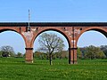
 Twemlow Railway Viaduct, Holmes Chapel - geograph.org.uk - 2817989.jpg 4 000 × 3 000; 4,02 MB
-
 Twemlow Viaduct - geograph.org.uk - 6126654.jpg 1 600 × 1 201; 730 KB
-
 Twemlow Viaduct - geograph.org.uk - 6126660.jpg 1 600 × 1 201; 398 KB
-
 Twemlow Viaduct and The River Dane - geograph.org.uk - 6126664.jpg 1 600 × 1 200; 716 KB
-
 Twemlow Viaduct over The River Dane - geograph.org.uk - 6126658.jpg 1 600 × 1 200; 720 KB
-
 Twemlow Viaduct, Holmes Chapel - geograph.org.uk - 4291508.jpg 1 024 × 768; 178 KB
-

-

-
-
 View east from Twemlow Viaduct - geograph.org.uk - 4698739.jpg 1 515 × 480; 485 KB
-
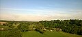
 View south-east from Twemlow Viaduct - geograph.org.uk - 4925488.jpg 1 024 × 768; 89 KB


