Category:Tylorstown
Vai alla navigazione
Vai alla ricerca
village and community in Rhondda Cynon Taf, Wales, UK .jpg)  | |||||
| Carica un file multimediale | |||||
| Audio della pronuncia | |||||
|---|---|---|---|---|---|
| Istanza di | |||||
| Luogo | Rhondda Cynon Taf, Galles | ||||
 | |||||
Cymraeg: Pentref a chymuned yng Nghwm Rhondda ym mwrdeisdref sirol Rhondda Cynon Taf yw Pendyrus (Saesneg: Tylorstown. Roedd y boblogaeth yn 2001 yn 4,715.
English: Tylorstown is a village located in the Rhondda valley, in the county borough of Rhondda Cynon Taf, Wales. It was founded by Alfred Tylor who set up an early coal mining operation in the location in the mid 1800s.
Sottocategorie
Questa categoria contiene le 3 sottocategorie indicate di seguito, su un totale di 3.
File nella categoria "Tylorstown"
Questa categoria contiene 200 file, indicati di seguito, su un totale di 271.
(pagina precedente) (pagina successiva)-
 2010 Wales Rhondda Cynon Taf Community Tylorstown map.svg 512 × 737; 416 KB
-
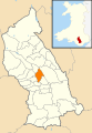 2024 Wales Rhondda Cynon Taf Community Tylorstown map.svg 512 × 737; 369 KB
-
 8 Til Late, Tylorstown - geograph.org.uk - 3607703.jpg 716 × 800; 147 KB
-

-
 A4233 roundabout Pontygwaith - geograph.org.uk - 3598807.jpg 799 × 800; 202 KB
-
 A4233 through Pontygwaith - geograph.org.uk - 3587502.jpg 800 × 642; 141 KB
-
 Access road to Lidl Tylorstown - geograph.org.uk - 3611577.jpg 800 × 591; 124 KB
-
 Acts Community Church, Tylorstown - geograph.org.uk - 5042967.jpg 4 608 × 3 456; 3,7 MB
-

-
 Aptly named Prospect Place, Tylorstown - geograph.org.uk - 3607888.jpg 800 × 800; 190 KB
-
 Ashfield House, Tylorstown - geograph.org.uk - 3612689.jpg 800 × 536; 116 KB
-
 Baglan Street, Pontygwaith - geograph.org.uk - 3591028.jpg 800 × 551; 105 KB
-
 Base of a demolished building in Penrhys - geograph.org.uk - 4599791.jpg 800 × 552; 106 KB
-

-

-
 Brewery Street, Pontygwaith - geograph.org.uk - 3587543.jpg 800 × 640; 104 KB
-
 Brick urinal, Pontygwaith - geograph.org.uk - 3587536.jpg 800 × 702; 146 KB
-
 Brynbedw Road, Tylorstown - geograph.org.uk - 3607804.jpg 800 × 624; 141 KB
-
 Brynheulog Terrace Tylorstown - geograph.org.uk - 3589361.jpg 800 × 800; 262 KB
-
 Bus shelter and phonebox, Tylorstown - geograph.org.uk - 3612620.jpg 800 × 727; 162 KB
-
 Bus shelter skeleton, Penrhys - geograph.org.uk - 4426182.jpg 800 × 558; 126 KB
-
 Bus stop on East Road, Tylorstown - geograph.org.uk - 5338064.jpg 1 024 × 753; 207 KB
-

-

-
 Cinnamon Spice, Pontygwaith - geograph.org.uk - 3598820.jpg 800 × 681; 130 KB
-

-

-

-
 Cycle route 881 Pontygwaith - geograph.org.uk - 3598912.jpg 798 × 800; 174 KB
-

-

-
 Demolished building near Tylorstown Tip - geograph.org.uk - 4413675.jpg 4 000 × 3 000; 6,36 MB
-
 Demolished building near Tylorstown Tip - geograph.org.uk - 4413717.jpg 4 000 × 3 000; 5,12 MB
-

-
 Deri Terrace Pontygwaith - geograph.org.uk - 3598754.jpg 800 × 696; 158 KB
-

-
 Devonalds solicitors, Tylorstown - geograph.org.uk - 3606551.jpg 800 × 795; 131 KB
-
 Dolycoed Funeral Home, Tylorstown - geograph.org.uk - 3589300.jpg 800 × 509; 99 KB
-
 Down Llanwonno Road, Stanleytown - geograph.org.uk - 3605346.jpg 800 × 600; 137 KB
-
 Down School Street, Pontygwaith - geograph.org.uk - 3591201.jpg 800 × 722; 162 KB
-
 Dringo tyle - Climbing hill - geograph.org.uk - 4851778.jpg 640 × 480; 122 KB
-
 Duke of York, Tylorstown - geograph.org.uk - 3589208.jpg 800 × 679; 132 KB
-
 East Rd, Tylorstown - geograph.org.uk - 5042875.jpg 4 608 × 3 456; 3,76 MB
-
 East Road - geograph.org.uk - 6142340.jpg 2 048 × 1 536; 1,01 MB
-
 East Road houses, Tylorstown - geograph.org.uk - 3589213.jpg 800 × 565; 133 KB
-
 East Road houses, Tylorstown - geograph.org.uk - 3606544.jpg 800 × 669; 130 KB
-
 East Road houses, Tylorstown - geograph.org.uk - 3607940.jpg 800 × 562; 109 KB
-
 East side of Y Ty Capel Zion, Tylorstown - geograph.org.uk - 3599001.jpg 800 × 647; 158 KB
-

-
 Edmund St, Tylorstown - geograph.org.uk - 5043002.jpg 4 608 × 3 456; 3,96 MB
-

-
 Edmund Street play area, Tylorstown - geograph.org.uk - 3612848.jpg 800 × 652; 198 KB
-

-
 Empty billboard, Tylorstown - geograph.org.uk - 3606574.jpg 800 × 643; 135 KB
-

-

-
 FIL 2011-10.jpg 2 717 × 2 038; 1,64 MB
-
 FIL 2011-11.jpg 3 113 × 2 334; 2,04 MB
-
 FIL 2011-12.jpg 2 736 × 3 648; 2,83 MB
-
 FIL 2011-13.jpg 3 648 × 2 736; 2,73 MB
-
 FIL 2011-14.jpg 3 042 × 2 360; 1,83 MB
-
 Football club this way, Stanleytown - geograph.org.uk - 3605557.jpg 800 × 600; 140 KB
-

-

-
 Former County Police Station, Tylorstown - geograph.org.uk - 3610971.jpg 800 × 719; 163 KB
-
 Former Diamond Jubilee Hotel, Tylorstown - geograph.org.uk - 3611660.jpg 800 × 688; 133 KB
-

-

-

-
 Genesis Community Day Nursery Tylorstown - geograph.org.uk - 3612739.jpg 800 × 613; 127 KB
-
 Graig Street, Pontygwaith - geograph.org.uk - 3591162.jpg 800 × 591; 130 KB
-

-

-

-
 Heol Ioan houses, Penrhys - geograph.org.uk - 4426140.jpg 800 × 599; 91 KB
-

-
 Heol Pendyrus, Penrhys - geograph.org.uk - 4426166.jpg 800 × 616; 114 KB
-
 Heol Pendyrus, Penrhys - geograph.org.uk - 4599672.jpg 800 × 510; 91 KB
-

-
 Heol y Ffynon houses in Penrhys - geograph.org.uk - 4426066.jpg 800 × 585; 140 KB
-
 Heol y Ffynon houses, Penrhys - geograph.org.uk - 4426174.jpg 800 × 618; 88 KB
-
 Heol-y-waun houses in Penrhys - geograph.org.uk - 4599864.jpg 800 × 500; 118 KB
-
 Heol-y-Waun houses, Penrhys - geograph.org.uk - 4428551.jpg 800 × 435; 71 KB
-
 Hermon Flats, Pontygwaith - geograph.org.uk - 3587595.jpg 800 × 644; 120 KB
-
 Hillside paths above the Rhondda Fach valley - geograph.org.uk - 4413637.jpg 4 000 × 3 000; 3,88 MB
-
 Hillside view, Pontygwaith - geograph.org.uk - 3598697.jpg 800 × 580; 148 KB
-
 Holy Trinity Church, Tylorstown - geograph.org.uk - 3605996.jpg 800 × 669; 175 KB
-
 Holy Trinity Church, Tylorstown - geograph.org.uk - 5042975.jpg 3 456 × 4 608; 4,18 MB
-
 Holy Trinity Church, Tylorstown - geograph.org.uk - 5042981.jpg 4 608 × 3 456; 3,89 MB
-
 Holy Trinity Church, Tylorstown - geograph.org.uk - 5042983.jpg 4 608 × 3 456; 3,87 MB
-
 House construction in Tylorstown - geograph.org.uk - 3612892.jpg 800 × 600; 123 KB
-
 Houses above Heol Pendyrus, Penrhys - geograph.org.uk - 4599756.jpg 800 × 445; 110 KB
-

-
 Jim's Garden, Tylorstown - geograph.org.uk - 3612630.jpg 792 × 800; 189 KB
-
 Kieranz Kutz Barbers, Pontygwaith - geograph.org.uk - 3610850.jpg 800 × 630; 143 KB
-

-
 Large grassy roundabout in Penrhys - geograph.org.uk - 4419219.jpg 800 × 469; 102 KB
-
 Launderette and van, Pontygwaith - geograph.org.uk - 3587581.jpg 753 × 800; 136 KB
-
 Left turn for Rhondda Golf Club, Penrhys - geograph.org.uk - 4419205.jpg 800 × 559; 108 KB
-
 Lidl Supermarket - geograph.org.uk - 6142242.jpg 2 048 × 1 536; 1,04 MB
-
 Lidl, Tylorstown - geograph.org.uk - 3611112.jpg 800 × 476; 124 KB
-
 Llanfair Penrhys - geograph.org.uk - 4428510.jpg 800 × 737; 156 KB
-
 Llanwonno Road bridge, Stanleytown - geograph.org.uk - 3598923.jpg 800 × 714; 208 KB
-
 Llanwonno Road houses, Stanleytown - geograph.org.uk - 3605273.jpg 800 × 686; 152 KB
-
 Llanwonno Road Stanleytown - geograph.org.uk - 3605237.jpg 800 × 600; 142 KB
-
 Llanwonno, young firs - geograph.org.uk - 695750.jpg 640 × 480; 86 KB
-
 Lockup garage variety, Pontygwaith - geograph.org.uk - 3591213.jpg 800 × 581; 115 KB
-

-

-

-

-
 Lower Terrace junction, Stanleytown - geograph.org.uk - 3605655.jpg 800 × 688; 171 KB
-
 Lower Terrace, Stanleytown - geograph.org.uk - 3605636.jpg 800 × 636; 159 KB
-
 Madeline Street Pontygwaith - geograph.org.uk - 3591146.jpg 800 × 653; 133 KB
-
 Madeline Street, - geograph.org.uk - 3031232.jpg 640 × 480; 61 KB
-
 Madeline Street, Pontygwaith - geograph.org.uk - 3598681.jpg 1 024 × 768; 169 KB
-
 Mayfair Garden, Tylorstown - geograph.org.uk - 3606566.jpg 764 × 800; 131 KB
-
 Mostly Pound Shop, Pontygwaith - geograph.org.uk - 3587565.jpg 800 × 600; 108 KB
-
 MP Computer Services, Tylorstown - geograph.org.uk - 3610906.jpg 800 × 601; 123 KB
-
 Muddy path to the road near Tylorstown Tip - geograph.org.uk - 4413722.jpg 4 000 × 3 000; 3,6 MB
-

-

-

-

-
 NW edge of residential Tylorstown - geograph.org.uk - 3589236.jpg 800 × 502; 110 KB
-
 Ordnance Survey Cut Mark - geograph.org.uk - 5433264.jpg 640 × 403; 65 KB
-
 Ordnance Survey Cut Mark - geograph.org.uk - 5433266.jpg 640 × 371; 86 KB
-
 Ordnance Survey Cut Mark - geograph.org.uk - 5433270.jpg 640 × 351; 68 KB
-
 Ordnance Survey Cut Mark - geograph.org.uk - 5433271.jpg 640 × 397; 107 KB
-
 Ordnance Survey Cut Mark - geograph.org.uk - 5433274.jpg 640 × 379; 113 KB
-
 Ordnance Survey Cut Mark - geograph.org.uk - 5433276.jpg 640 × 387; 89 KB
-
 Ordnance Survey Cut Mark - geograph.org.uk - 5433289.jpg 640 × 628; 171 KB
-
 Ordnance Survey Cut Mark - geograph.org.uk - 5433291.jpg 640 × 507; 89 KB
-
 Ordnance Survey Cut Mark - geograph.org.uk - 5439929.jpg 640 × 292; 30 KB
-
 Ordnance Survey Cut Mark - geograph.org.uk - 5439930.jpg 640 × 316; 59 KB
-
 Ordnance Survey Cut Mark - geograph.org.uk - 5439931.jpg 640 × 362; 60 KB
-
 Ordnance Survey Cut Mark - geograph.org.uk - 5439932.jpg 640 × 349; 57 KB
-
 Ordnance Survey Cut Mark - geograph.org.uk - 5439933.jpg 640 × 373; 64 KB
-
 Ordnance Survey Cut Mark - geograph.org.uk - 5439934.jpg 640 × 314; 58 KB
-
 Ordnance Survey Cut Mark - geograph.org.uk - 5439935.jpg 640 × 334; 44 KB
-
 Ordnance Survey Cut Mark - geograph.org.uk - 5439936.jpg 640 × 318; 67 KB
-
 Ordnance Survey Cut Mark - geograph.org.uk - 5439937.jpg 640 × 329; 78 KB
-
 Ordnance Survey Cut Mark - geograph.org.uk - 5439938.jpg 640 × 342; 62 KB
-
 Ordnance Survey Cut Mark - geograph.org.uk - 5439939.jpg 640 × 355; 58 KB
-
 Ordnance Survey Cut Mark - geograph.org.uk - 5439940.jpg 640 × 366; 72 KB
-
 Ordnance Survey Cut Mark - geograph.org.uk - 5439941.jpg 455 × 640; 62 KB
-
 Ordnance Survey Cut Mark - geograph.org.uk - 5439942.jpg 640 × 346; 71 KB
-
 Ordnance Survey Cut Mark - geograph.org.uk - 5439943.jpg 640 × 369; 88 KB
-
 Our Lady and Jesus statue, Penrhys - geograph.org.uk - 4424130.jpg 800 × 569; 95 KB
-
 Out buildings, Penrhys - geograph.org.uk - 3031226.jpg 640 × 480; 108 KB
-

-
 Path from Stanleytown to Tylorstown - geograph.org.uk - 3605700.jpg 800 × 600; 196 KB
-

-

-

-
 Pendyrus Court, Tylorstown - geograph.org.uk - 3607835.jpg 800 × 532; 134 KB
-

-
 Penrhys footpath - geograph.org.uk - 4428526.jpg 800 × 605; 136 KB
-
 Penrhys houses - geograph.org.uk - 4599638.jpg 800 × 553; 93 KB
-
 Penrhys Partnership office, Penrhys - geograph.org.uk - 4428483.jpg 661 × 800; 151 KB
-
 Penrhys Primary School - geograph.org.uk - 4426112.jpg 800 × 512; 103 KB
-
 Penrhys Village Centre - geograph.org.uk - 4428441.jpg 800 × 630; 124 KB
-
 Pipe bridge and road bridge, Pontygwaith - geograph.org.uk - 3598846.jpg 800 × 600; 204 KB
-

-

-
 Pontygwaith Community Centre - geograph.org.uk - 3598710.jpg 800 × 654; 137 KB
-
 Pontygwaith Newsagents - geograph.org.uk - 3587561.jpg 800 × 757; 143 KB
-

-
 Pontygwaith Post Office - geograph.org.uk - 3587603.jpg 800 × 576; 118 KB
-

-
 Pontygwaith Primary School, Pontygwaith - geograph.org.uk - 3591152.jpg 799 × 800; 169 KB
-

-
 Prospect Place, Tylorstown - geograph.org.uk - 5042893.jpg 4 608 × 3 456; 3,96 MB
-

-
 Remains of a building, Stanleytown - geograph.org.uk - 3605548.jpg 800 × 514; 122 KB
-

-

-
 Rhondda Fach Trail, Stanleytown - geograph.org.uk - 3605230.jpg 800 × 600; 174 KB
-

-
 River footbridge, Tylorstown - geograph.org.uk - 3605800.jpg 800 × 600; 221 KB
-
 Riverside track junction near Ferndale - geograph.org.uk - 3623574.jpg 800 × 600; 203 KB
-
 Riverside track junction, Tylorstown - geograph.org.uk - 3623552.jpg 800 × 600; 240 KB
-
 Riverside track towards Ferndale - geograph.org.uk - 3623604.jpg 800 × 600; 243 KB
-

-

-
 Road through the NE edge of Penrhys - geograph.org.uk - 4599828.jpg 800 × 622; 135 KB
-

-

-
 Roundabout at the junction of four 1km squares, Tylorstown - geograph.org.uk - 5043008.jpg 4 608 × 3 456; 3,74 MB
-
 Roundabout on A4233 - geograph.org.uk - 6142252.jpg 2 048 × 1 536; 951 KB
-

-

-
 SE boundary of Ferndale - geograph.org.uk - 3589347.jpg 799 × 800; 196 KB
-
 SE boundary of Penrhys - geograph.org.uk - 4419048.jpg 800 × 621; 119 KB
-
 Shadowy bus shelter in Tylorstown - geograph.org.uk - 3611096.jpg 800 × 550; 118 KB
-
 Sheppards Pharmacy, Tylorstown - geograph.org.uk - 3610915.jpg 800 × 606; 121 KB
-
 SHL Autos Ltd, Tylorstown - geograph.org.uk - 3607877.jpg 800 × 605; 116 KB
-

-
 Southern boundary of Tylorstown - geograph.org.uk - 3587632.jpg 800 × 746; 104 KB
-


_-_geograph.org.uk_-_3587475.jpg)


