Category:U.S. Route 90
Vai alla navigazione
Vai alla ricerca
 | numero: | (ninety-) |
|---|---|---|
| U.S. Routes: | 70 · 71 · 72 · 73 · 74 · 75 · 76 · 77 · 78 · 79 · 80 · 81 · 82 · 83 · 84 · 85 · 87 · 89 · 90 · 91 · 92 · 93 · 95 · 96 · 97 · 98 · 99 · 101 · 107 |
U.S. Numbered Highway in southeastern United States   | |||||
| Carica un file multimediale | |||||
| Istanza di | |||||
|---|---|---|---|---|---|
| Luogo |
| ||||
| Sistema di trasporto |
| ||||
| Proprietario | |||||
| Gestore | |||||
| Consiste di | |||||
| Data di fondazione o creazione |
| ||||
| Lunghezza |
| ||||
| |||||
English: Media related to 'U.S. Route 90, a 1,633-mile (2,628 km) U.S. Numbered Highway in the United States, that connects Texas State Highway 54 in Van Horn, Texas with Florida State Road A1A in Jacksonville Beach, Florida.
Sottocategorie
Questa categoria contiene le 11 sottocategorie indicate di seguito, su un totale di 11.
File nella categoria "U.S. Route 90"
Questa categoria contiene 11 file, indicati di seguito, su un totale di 11.
-
 Map showing major roads between NYC, Kansas City, and Houston, 1928 NYT.png 2 887 × 2 268; 406 KB
-
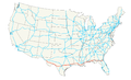 US 90 map.png 2 128 × 1 286; 120 KB
-
 US90wDoNotPickUpHitchhikers (21410987002).jpg 1 200 × 800; 514 KB
-
 US90wExit (21235008039).jpg 1 200 × 800; 426 KB
-
 US90wLongOverpassFromLeft (20799202134).jpg 1 200 × 800; 469 KB
-
 US90wRoad01 (21430331971).jpg 1 200 × 800; 545 KB
-
 US90wRoad19TwoLane70mphLimit (21235003759).jpg 1 200 × 800; 464 KB
-
 US90wRoad20Cloudy (21430327001).jpg 800 × 1 200; 416 KB
-
 US90wRoadCurve13 (21421887355).jpg 1 200 × 800; 368 KB
-
 US90wRoadUS83nsTX55nSignsUvalde (21410984922).jpg 1 200 × 800; 684 KB
-
 US90wTrussBridgeBlancoCreek (21395660356).jpg 1 200 × 800; 424 KB

.jpg)
.jpg)
.jpg)
.jpg)
.jpg)
.jpg)
.jpg)
.jpg)
.jpg)