Category:Ubuntu Local Municipality
Vai alla navigazione
Vai alla ricerca
local municipality in the Northern Cape, South Africa .svg) | |||||
| Carica un file multimediale | |||||
| Istanza di |
| ||||
|---|---|---|---|---|---|
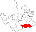
| Luogo | Municipalità distrettuale di Pixley ka Seme, provincia del Capo Settentrionale, Sudafrica | ||||
| Capitale | |||||
| Data di fondazione o creazione |
| ||||
| Popolazione |
| ||||
| Altezza sul mare |
| ||||
 | |||||
Afrikaans: Die Ubuntu Plaaslike Munisipaliteit is een van die plaaslike munisipaliteite in die Pixley ka Seme-distriksmunisipaliteit in die Noord-Kaap, Suid-Afrika.
Deutsch: Ubuntu ist eine Gemeinde im Distrikt Pixley Ka Seme, Provinz Nordkap in Südafrika. Im Jahr 2001 betrug die Bevölkerung 16.368 auf einer Gesamtfläche von 20.389 km². Sitz der Gemeindeverwaltung ist Victoria West.
English: Ubuntu Local Municipality is a municipality in the Pixley ka Seme District Municipality of the Northern Cape province of South Africa.
Sottocategorie
Questa categoria contiene le 3 sottocategorie indicate di seguito, su un totale di 3.
L
R
V
File nella categoria "Ubuntu Local Municipality"
Questa categoria contiene 4 file, indicati di seguito, su un totale di 4.
-
 Map of the Northern Cape with Ubuntu highlighted (2006).svg 750 × 764; 538 KB
-
 Map of the Northern Cape with Ubuntu highlighted (2011).svg 750 × 764; 392 KB
-
 Map of the Northern Cape with Ubuntu highlighted (2016).svg 750 × 764; 550 KB
-
 NC071 locator.svg 1 000 × 899; 287 KB
.svg)
.svg)
