Category:Unstone
Aller à la navigation
Aller à la recherche
village britannique  | |||||
| Téléverser des médias | |||||
| Nature de l’élément | |||||
|---|---|---|---|---|---|
| Lieu | North East Derbyshire, Derbyshire, Midlands de l'Est, Angleterre | ||||
 | |||||
Sous-catégories
Cette catégorie comprend 7 sous-catégories, dont les 7 ci-dessous.
A
- Apperknowle (12 F)
C
H
- Hundall (5 F)
M
- Middle Handley (4 F)
N
- Nether Handley (1 F)
U
- Unstone Green (3 F)
- Unstone War Memorial (2 F)
Média dans la catégorie « Unstone »
Cette catégorie comprend 295 fichiers, dont les 200 ci-dessous.
(page précédente) (page suivante)-
 "The Barrack" across the village green in Apperknowle - geograph.org.uk - 2876853.jpg 2 302 × 3 070 ; 1,65 Mio
-
 "The Devonshire Arms" in Middle Handley - geograph.org.uk - 3180091.jpg 4 608 × 3 072 ; 3,54 Mio
-
 "The Horse and Jockey" at Unstone Green - geograph.org.uk - 2835362.jpg 2 368 × 1 776 ; 1 014 kio
-
 "The Miners Arms", Hundall, Derbyshire - geograph.org.uk - 3179838.jpg 4 009 × 2 673 ; 2,38 Mio
-
 "The Travellers Rest" at Apperknowle - geograph.org.uk - 4837664.jpg 5 106 × 3 836 ; 4,87 Mio
-
 45-54 St John's Road, Unstone - geograph.org.uk - 1867847.jpg 1 280 × 854 ; 300 kio
-
 47659 Unstone.jpg 1 585 × 1 071 ; 207 kio
-
 A bend in Springwell Hill (B6052) - geograph.org.uk - 4376599.jpg 640 × 480 ; 55 kio
-
 A Dead Roadside Tree at Middle Handley - geograph.org.uk - 2420843.jpg 2 472 × 3 296 ; 928 kio
-
 A farm track south of Hundall - geograph.org.uk - 3180260.jpg 2 962 × 4 146 ; 2,99 Mio
-
 A harvested field - geograph.org.uk - 1995272.jpg 640 × 480 ; 96 kio
-
 A view of Bull Close Farm - geograph.org.uk - 5614472.jpg 4 908 × 3 612 ; 3,76 Mio
-
 A view of Ramshaw Woods - geograph.org.uk - 5614494.jpg 3 801 × 5 067 ; 4,16 Mio
-
 A view of West Handley - geograph.org.uk - 1995234.jpg 640 × 480 ; 85 kio
-
 A way kept clear - geograph.org.uk - 1867875.jpg 1 280 × 854 ; 408 kio
-
 Across a field to a roadside pub - geograph.org.uk - 2484226.jpg 3 648 × 2 736 ; 6,1 Mio
-
 Air strip near Apperknowle - geograph.org.uk - 3856306.jpg 1 600 × 1 200 ; 516 kio
-
 Air Strip, warning notice - geograph.org.uk - 2484205.jpg 3 648 × 2 736 ; 5,67 Mio
-

-
 Allotments, Unstone - geograph.org.uk - 4277063.jpg 640 × 430 ; 80 kio
-
 Any Old Iron - geograph.org.uk - 1824513.jpg 2 336 × 3 504 ; 6,44 Mio
-
 Apperknowle Methodist Church - geograph.org.uk - 4837662.jpg 3 765 × 4 909 ; 4,86 Mio
-
 Apperknowle Village - geograph.org.uk - 2485914.jpg 2 848 × 2 144 ; 1,5 Mio
-
 Approach to Hundall from the north - geograph.org.uk - 2454169.jpg 640 × 360 ; 56 kio
-
 Approaching Apperknowle on the byway from the northeast - geograph.org.uk - 3856311.jpg 1 600 × 1 200 ; 628 kio
-
 Approaching Road Junction near Moortop Farm - geograph.org.uk - 2850197.jpg 3 292 × 2 468 ; 1,16 Mio
-
 Ash Lane eastwards - geograph.org.uk - 6311158.jpg 640 × 488 ; 71 kio
-
 Ash Lane Farmhouse, West Handley - geograph.org.uk - 3179854.jpg 4 041 × 2 694 ; 2,44 Mio
-
 Ash Lane towards Summerley - geograph.org.uk - 6311128.jpg 640 × 451 ; 75 kio
-
 Ash Lane-Long Lane junction - geograph.org.uk - 6311159.jpg 640 × 412 ; 59 kio
-
 B6057 between Unstone and Unstone Green - geograph.org.uk - 2462073.jpg 950 × 713 ; 297 kio
-
 Barn and stables at Unstone Mill - geograph.org.uk - 1867964.jpg 1 280 × 854 ; 383 kio
-
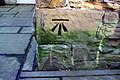 Benchmark on Ouzle Bank Cottage - geograph.org.uk - 6059533.jpg 1 024 × 683 ; 234 kio
-
 Beneath Unstone Viaduct - geograph.org.uk - 3219396.jpg 1 600 × 1 200 ; 709 kio
-
 Bluebell wood - geograph.org.uk - 1867872.jpg 1 280 × 854 ; 530 kio
-
 Bridleway leaving the B6057 - geograph.org.uk - 1995183.jpg 640 × 480 ; 138 kio
-
 Broken down signpost at West Handley - geograph.org.uk - 1995254.jpg 640 × 480 ; 103 kio
-
 Builder's yard, Unstone - geograph.org.uk - 1993836.jpg 640 × 480 ; 101 kio
-
 Buildings at Bull Close Farm - geograph.org.uk - 6059560.jpg 1 024 × 680 ; 201 kio
-
 Bull Close Farm - geograph.org.uk - 3749210.jpg 3 814 × 1 814 ; 4,22 Mio
-
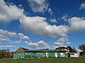 Clouds over Apperknowle's old cricket pavilion - geograph.org.uk - 4837683.jpg 5 105 × 3 799 ; 4,42 Mio
-
 Coke Oven at Ramshaw - geograph.org.uk - 1867969.jpg 1 280 × 854 ; 447 kio
-
 Colliery remains near Unstone - geograph.org.uk - 1735355.jpg 1 280 × 853 ; 402 kio
-
 Communications mast near Unstone - geograph.org.uk - 6311147.jpg 640 × 640 ; 70 kio
-
 Countryside around Manor Farm, Hundall - geograph.org.uk - 2454177.jpg 950 × 713 ; 294 kio
-
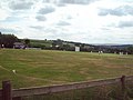 Cricket Match at Hundall - geograph.org.uk - 2420930.jpg 640 × 480 ; 54 kio
-
 Crop field Nether Handley - geograph.org.uk - 4376606.jpg 640 × 480 ; 67 kio
-
 Crossroads near Apperknowle - geograph.org.uk - 2484231.jpg 3 648 × 2 736 ; 4,51 Mio
-
 Dale Farm, Nether Handley - geograph.org.uk - 4376595.jpg 640 × 408 ; 52 kio
-
 Damaged gates north of Unstone - geograph.org.uk - 3856457.jpg 1 600 × 1 200 ; 457 kio
-

-
 Danger deep water - geograph.org.uk - 1995214.jpg 640 × 480 ; 69 kio
-
 Dead elm tree in field - geograph.org.uk - 2485444.jpg 3 648 × 2 736 ; 4,36 Mio
-
 Dead tree by Staveley Lane, Nether Handley - geograph.org.uk - 3180132.jpg 4 037 × 2 884 ; 3,3 Mio
-
 Derbyshire landscape - geograph.org.uk - 1735391.jpg 1 280 × 843 ; 254 kio
-
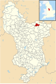 Derbyshire UK parish map highlighting Unstone.svg 888 × 1 308 ; 2,35 Mio
-
 Devonshire Arms, Middle Handley - geograph.org.uk - 3166551.jpg 1 024 × 601 ; 377 kio
-
 Devonshire Arms, Middle Handley - geograph.org.uk - 3775726.jpg 3 978 × 2 206 ; 4,77 Mio
-
 Dinner time - geograph.org.uk - 6311151.jpg 640 × 532 ; 143 kio
-
 Doggy-friendly stile post - geograph.org.uk - 1993777.jpg 480 × 640 ; 103 kio
-
 Down through a meadow to Unstone - geograph.org.uk - 1993825.jpg 640 × 480 ; 52 kio
-
 Entering New Whittington - geograph.org.uk - 4376589.jpg 640 × 411 ; 62 kio
-
 Farm beside Back Road, Apperknowle - geograph.org.uk - 3856318.jpg 1 600 × 1 200 ; 582 kio
-
 Farm buildings and footpath, West Handley - geograph.org.uk - 3166896.jpg 1 024 × 768 ; 459 kio
-
 Farm land by Stubbing Wood - geograph.org.uk - 1995219.jpg 640 × 480 ; 96 kio
-
 Farm, Staveley Lane, Nether Handley - geograph.org.uk - 2453991.jpg 950 × 609 ; 254 kio
-
 Farmland near Unstone Green - geograph.org.uk - 3423102.jpg 640 × 592 ; 113 kio
-
 Field and trees north of Grasscroft Wood - geograph.org.uk - 2454295.jpg 950 × 713 ; 304 kio
-
 Field below Middle Handley - geograph.org.uk - 3166887.jpg 1 024 × 768 ; 412 kio
-
 Field gate near Woodsmithies Farm - geograph.org.uk - 1995191.jpg 640 × 480 ; 103 kio
-
 Field with poppies, Middle Handley - geograph.org.uk - 2485441.jpg 3 648 × 2 736 ; 5,92 Mio
-
 Fields and country views near Unstone - geograph.org.uk - 2462016.jpg 950 × 655 ; 260 kio
-
 Fields and trees near Ouzel Bank Cottage - geograph.org.uk - 2460388.jpg 950 × 643 ; 281 kio
-
 Fields north of West Handley - geograph.org.uk - 3179859.jpg 4 291 × 2 861 ; 2,82 Mio
-
 Football field at Unstone - geograph.org.uk - 1735365.jpg 1 280 × 853 ; 274 kio
-
 Football pitch at Unstone beside the Drone Valley Way - geograph.org.uk - 3308102.jpg 4 000 × 2 248 ; 1,83 Mio
-
 Footpath from Hundall Lane - geograph.org.uk - 6311119.jpg 640 × 450 ; 72 kio
-
 Footpath in Ramshaw Wood - geograph.org.uk - 3307886.jpg 800 × 600 ; 204 kio
-
 Footpath near Bull Close Farm - geograph.org.uk - 2398918.jpg 3 296 × 2 472 ; 1,05 Mio
-
 Footpath north from Summerley - geograph.org.uk - 2836546.jpg 2 393 × 1 795 ; 1,27 Mio
-
 Footpath Overlooking Unstone Hall - geograph.org.uk - 2398941.jpg 3 296 × 2 472 ; 1,09 Mio
-
 Footpath sign on Hundall Lane - geograph.org.uk - 6311120.jpg 640 × 513 ; 116 kio
-
 Footpath to Long Lane - geograph.org.uk - 2454234.jpg 713 × 950 ; 318 kio
-
 Former colliery tramway - geograph.org.uk - 1735376.jpg 1 280 × 853 ; 272 kio
-
 Former colliery tramway - geograph.org.uk - 1735384.jpg 1 280 × 846 ; 289 kio
-
 Former colliery tramway - geograph.org.uk - 1735389.jpg 1 280 × 853 ; 284 kio
-
 Gas pipeline information marker on Hundall Lane - geograph.org.uk - 6311121.jpg 602 × 640 ; 131 kio
-
 Gas pipeline marker on Hundall Lane - geograph.org.uk - 6311122.jpg 640 × 487 ; 62 kio
-
 Gate on a footpath - geograph.org.uk - 3219404.jpg 1 200 × 1 600 ; 631 kio
-
 Greystoc House - geograph.org.uk - 3564292.jpg 1 600 × 1 200 ; 302 kio
-
 H.S.T, Unstone Valley (3724798240).jpg 1 205 × 892 ; 250 kio
-
 Handley Road, Glasshouse Green - geograph.org.uk - 3308135.jpg 4 000 × 3 000 ; 2,12 Mio
-
 He said it was a downhill walk today..... - geograph.org.uk - 3308107.jpg 4 000 × 2 248 ; 2,46 Mio
-
 Highgate Lane towards Dronfield - geograph.org.uk - 2460393.jpg 950 × 713 ; 307 kio
-
 Hillside fields around Hundall - geograph.org.uk - 2454127.jpg 950 × 644 ; 265 kio
-
 Horse and Jockey Public House in Unstone Green - geograph.org.uk - 2398955.jpg 3 296 × 2 472 ; 1,01 Mio
-
 Horses in field at Summerley - geograph.org.uk - 2484200.jpg 3 648 × 2 736 ; 6,15 Mio
-
 House on St John's Road, Unstone - geograph.org.uk - 3540175.jpg 3 556 × 2 667 ; 1,81 Mio
-
 Houses at Unstone - geograph.org.uk - 2485354.jpg 2 848 × 2 144 ; 1,5 Mio
-
 Hundall - Approaching Windmill Lane - geograph.org.uk - 1016552.jpg 640 × 480 ; 123 kio
-
 Hundall - Storm approaching - geograph.org.uk - 1016540.jpg 640 × 480 ; 97 kio
-
 Hundall - Windmill Lane - geograph.org.uk - 1016545.jpg 640 × 480 ; 132 kio
-
 Hundall Cricket Club - geograph.org.uk - 1995208.jpg 640 × 480 ; 64 kio
-
 Hundall Lane eastwards - geograph.org.uk - 6311124.jpg 640 × 465 ; 83 kio
-
 Hundall Lane eastwards - geograph.org.uk - 6311152.jpg 640 × 452 ; 76 kio
-
 Hundall Lane westwards - geograph.org.uk - 6311153.jpg 640 × 450 ; 51 kio
-
 Hundall Lane-Crown Lane junction - geograph.org.uk - 6311123.jpg 640 × 443 ; 91 kio
-
 In Nether Handley - geograph.org.uk - 3180124.jpg 4 202 × 3 002 ; 2,78 Mio
-
 Landscape in grey - geograph.org.uk - 1735396.jpg 1 280 × 853 ; 207 kio
-
 Lane towards Apperknowle - geograph.org.uk - 2454110.jpg 950 × 545 ; 216 kio
-
 Lightwood Road, Marsh Lane - geograph.org.uk - 3775722.jpg 4 000 × 2 248 ; 4,16 Mio
-
 Line of tramroad - geograph.org.uk - 1867867.jpg 854 × 1 280 ; 869 kio
-
 Long Lane by Stubbing Wood - geograph.org.uk - 3166902.jpg 1 024 × 768 ; 466 kio
-
 Long Lane crosses Morton Lane - geograph.org.uk - 6311162.jpg 640 × 397 ; 43 kio
-
 Long Lane descending by Glasshouse Common - geograph.org.uk - 2454282.jpg 950 × 700 ; 294 kio
-
 Long Lane past Stubbing Wood - geograph.org.uk - 2454256.jpg 714 × 950 ; 321 kio
-
 Long Lane towards Coal Aston - geograph.org.uk - 6311163.jpg 640 × 440 ; 43 kio
-
 Looking across fields from Summerley Road - geograph.org.uk - 1451196.jpg 640 × 480 ; 76 kio
-
 Looking along Morton Lane - geograph.org.uk - 2454095.jpg 950 × 569 ; 232 kio
-
 Looking down Long Lane - geograph.org.uk - 2454191.jpg 950 × 713 ; 311 kio
-
 Lych Gate Entrance to Middle Handley Church - geograph.org.uk - 2420854.jpg 640 × 480 ; 125 kio
-
 Methodist chapel, Apperknowle - geograph.org.uk - 3775347.jpg 3 966 × 2 188 ; 4,94 Mio
-
 Middle Handley to Apperknowle Road - geograph.org.uk - 467673.jpg 640 × 480 ; 88 kio
-
 Middle Handley, ploughed field and view to Chesterfield - geograph.org.uk - 3180108.jpg 2 941 × 4 117 ; 3,29 Mio
-
 Miners Arms, Hundall - geograph.org.uk - 1867891.jpg 1 280 × 854 ; 168 kio
-
 Misty morning - geograph.org.uk - 3775337.jpg 4 000 × 2 248 ; 4,16 Mio
-
 Moortop Farm - geograph.org.uk - 467681.jpg 640 × 480 ; 107 kio
-
 Morton Lane towards Coal Aston - geograph.org.uk - 6311161.jpg 640 × 463 ; 53 kio
-
 Morton Lane-Main Road junction - geograph.org.uk - 6311160.jpg 640 × 467 ; 52 kio
-
 Near Ramshaw Farm - geograph.org.uk - 4277075.jpg 640 × 430 ; 39 kio
-
-
 Newly planted woodland - geograph.org.uk - 3579356.jpg 640 × 480 ; 127 kio
-
 Nissen hut at Apperknowle - geograph.org.uk - 1867861.jpg 1 280 × 854 ; 342 kio
-
 North entrance to Black Piece Wood - geograph.org.uk - 3540185.jpg 3 648 × 2 736 ; 2,37 Mio
-
 Old colliery workings^ - geograph.org.uk - 1735392.jpg 1 280 × 853 ; 272 kio
-
 Old stone cottage in Hundall, Derbyshire - geograph.org.uk - 3180257.jpg 4 298 × 3 070 ; 2,86 Mio
-
 Old tree - geograph.org.uk - 3775731.jpg 3 791 × 2 166 ; 4,27 Mio
-
 Old Whittington Lane, Unstone Green - geograph.org.uk - 1867960.jpg 1 280 × 854 ; 264 kio
-
 On the edge of Stubbing Wood - geograph.org.uk - 3307899.jpg 800 × 600 ; 204 kio
-
 On the Unstone Line - geograph.org.uk - 3856462.jpg 1 600 × 1 200 ; 1,03 Mio
-
 Ouzle Bank Cottage - geograph.org.uk - 3752923.jpg 800 × 533 ; 175 kio
-
 Ouzle Bank Cottage - geograph.org.uk - 3856478.jpg 1 600 × 1 200 ; 641 kio
-
 Ouzle Bank Cottage, Dronfield - geograph.org.uk - 1422180.jpg 480 × 640 ; 92 kio
-
 Ouzle Bank Cottage, Highgate Lane - geograph.org.uk - 6059547.jpg 1 024 × 683 ; 195 kio
-
 Overhanging Beech Tree at Summerley Hall - geograph.org.uk - 2013398.jpg 3 296 × 2 472 ; 952 kio
-
 Parkgate Farm - geograph.org.uk - 2939306.jpg 3 296 × 2 472 ; 1,09 Mio
-
 Parkgate Farm - geograph.org.uk - 4376585.jpg 640 × 480 ; 56 kio
-
 Parkgate Lane - View towards Parkgate Farm - geograph.org.uk - 1050285.jpg 640 × 480 ; 53 kio
-
 Pasture by Ouzle Bank Cottage - geograph.org.uk - 1426576.jpg 640 × 480 ; 76 kio
-
 Pasture near Summerley - geograph.org.uk - 1986444.jpg 2 848 × 2 144 ; 1,53 Mio
-
 Path through a field of oil-seed rape - geograph.org.uk - 1993788.jpg 640 × 480 ; 87 kio
-
 Path to Middle Handley - geograph.org.uk - 3166889.jpg 1 024 × 768 ; 393 kio
-
 Patterns in the crop - geograph.org.uk - 1995259.jpg 640 × 479 ; 112 kio
-
 Phone box and signpost in Middle Handley - geograph.org.uk - 3180096.jpg 2 964 × 4 149 ; 2,4 Mio
-
 Poppies by the B6052 to Eckington - geograph.org.uk - 2453994.jpg 950 × 673 ; 274 kio
-
 Public footpath towards New Whittington - geograph.org.uk - 6311148.jpg 640 × 464 ; 124 kio
-
 Quarry Road, Apperknowle - geograph.org.uk - 1437762.jpg 640 × 480 ; 65 kio
-
 Railway towards Sheffield, Unstone - geograph.org.uk - 3423096.jpg 640 × 505 ; 118 kio
-
 Ramshaw lodge coke oven - geograph.org.uk - 175117.jpg 640 × 419 ; 96 kio
-
 Ramshaw Wood - geograph.org.uk - 4277067.jpg 640 × 430 ; 38 kio
-
 Red-legged partridge - geograph.org.uk - 4376603.jpg 769 × 548 ; 277 kio
-
 Restricted byway to Apperknowle - geograph.org.uk - 3856299.jpg 1 600 × 1 200 ; 659 kio
-
 Ripening crops - geograph.org.uk - 1993804.jpg 640 × 480 ; 103 kio
-
 Rising farmland towards Apperknowle - geograph.org.uk - 2462050.jpg 950 × 713 ; 288 kio
-
 River Drone 362537 4d9dc2db.jpg 640 × 480 ; 117 kio
-
 Road Junction near Apperknowle - geograph.org.uk - 2013338.jpg 3 296 × 2 472 ; 1,02 Mio
-
 Rural Scene near Hundall - geograph.org.uk - 2420948.jpg 3 296 × 2 472 ; 1,02 Mio
-
 Signpost by Air Strip near Apperknowle - geograph.org.uk - 2013198.jpg 3 296 × 2 472 ; 1 011 kio
-
 Signpost where Long Lane crosses Morton Lane - geograph.org.uk - 6311164.jpg 640 × 476 ; 44 kio
-
 Small island in a fishing pond south of Hundall - geograph.org.uk - 3180256.jpg 4 298 × 3 070 ; 3,45 Mio
-
 South Close, Unstone Green - geograph.org.uk - 2462086.jpg 950 × 646 ; 261 kio
-
 Southgate Lodge, Middle Handley - geograph.org.uk - 3180116.jpg 4 434 × 2 956 ; 2,92 Mio
-
 Spring Bank - geograph.org.uk - 1735370.jpg 1 280 × 853 ; 258 kio
-
 Springwell Hill (B6052) - geograph.org.uk - 4376592.jpg 640 × 480 ; 76 kio
-
 Springwell Hill - geograph.org.uk - 4750583.jpg 800 × 533 ; 149 kio
-
 St John's Road, Unstone - geograph.org.uk - 1867843.jpg 1 280 × 854 ; 282 kio
-
 St John's Terrace, Unstone - geograph.org.uk - 2462059.jpg 950 × 730 ; 306 kio
-
 Steps on a path through Binkley Wood - geograph.org.uk - 1995267.jpg 480 × 640 ; 144 kio
-
 Steps to Greystoc House - geograph.org.uk - 3564295.jpg 1 200 × 1 600 ; 401 kio
-
 Summerley beehive coke ovens - geograph.org.uk - 1735330.jpg 1 280 × 853 ; 443 kio
-
 Summerley Farmhouse, Summerley - geograph.org.uk - 2836553.jpg 2 440 × 1 830 ; 1,68 Mio
-
 Summerley Lower Road - geograph.org.uk - 3579367.jpg 640 × 480 ; 96 kio
-
 Summerley Lower Road - geograph.org.uk - 3579372.jpg 640 × 480 ; 78 kio
-
 Summerley Lower Road and the hillside above - geograph.org.uk - 2461387.jpg 950 × 713 ; 306 kio
-
 Summerley Road - geograph.org.uk - 2836544.jpg 1 952 × 2 608 ; 2,14 Mio
-
 Summerley Road towards Apperknowle - geograph.org.uk - 2461384.jpg 950 × 713 ; 295 kio
-
 Summerley Road towards Apperknowle - geograph.org.uk - 6311126.jpg 640 × 435 ; 82 kio
-
 Summerley Road, Apperknowle - geograph.org.uk - 3775354.jpg 4 000 × 2 248 ; 5,13 Mio
-
 Thatched Farm in West Handley - geograph.org.uk - 2420895.jpg 3 296 × 2 472 ; 1,08 Mio
-
 The B6057 Road into Unstone - geograph.org.uk - 2398949.jpg 3 296 × 2 472 ; 1,06 Mio
-
 The Devonshire Arms - geograph.org.uk - 3776116.jpg 800 × 533 ; 76 kio
-
 The Devonshire arms. - geograph.org.uk - 6242922.jpg 1 024 × 768 ; 209 kio
-
 The former Post Office at Unstone - geograph.org.uk - 1986440.jpg 2 848 × 2 144 ; 1,46 Mio
-
 The Midland Mainline at Unstone Viaduct - geograph.org.uk - 2000919.jpg 2 848 × 2 144 ; 1,54 Mio
-
 The Miners Arms - geograph.org.uk - 3307894.jpg 800 × 600 ; 114 kio
-
 The Miners Arms - geograph.org.uk - 3308124.jpg 4 000 × 3 000 ; 2,01 Mio
-
 The Miners arms in Hundall. - geograph.org.uk - 6242919.jpg 1 024 × 768 ; 171 kio
-
 The new Post Office at Unstone - geograph.org.uk - 2001264.jpg 2 848 × 2 144 ; 836 kio
-
 The River Drone near Unstone - geograph.org.uk - 2420966.jpg 3 296 × 2 472 ; 1,02 Mio
-
 The sky and "The Travellers Rest", Apperknowle - geograph.org.uk - 4837686.jpg 3 632 × 4 873 ; 3,42 Mio


_-_geograph.org.uk_-_4376599.jpg)


.jpg)


_-_geograph.org.uk_-_4376592.jpg)


