Category:Valley of Ten Thousand Smokes
Zur Navigation springen
Zur Suche springen
vulkanisch aktive Region im US-Bundesstaat Alaska  | |||||
| Medium hochladen | |||||
| Ist ein(e) | |||||
|---|---|---|---|---|---|
| Liegt in Schutzgebiet | |||||
| Ort | Katmai-Nationalpark, Lake and Peninsula Borough, Alaska | ||||
| Gebirgszug | |||||
 | |||||
Unterkategorien
Es werden 9 von insgesamt 9 Unterkategorien in dieser Kategorie angezeigt:
In Klammern die Anzahl der enthaltenen Kategorien (K), Seiten (S), Dateien (D)
R
- River Lethe (Alaska) (7 D)
Medien in der Kategorie „Valley of Ten Thousand Smokes“
Folgende 91 Dateien sind in dieser Kategorie, von 91 insgesamt.
-
-
 AKPen2.jpg 405 × 600; 82 KB
-
 AshContours.png 605 × 740; 170 KB
-
 AshFlowColumn.png 711 × 757; 116 KB
-

-
 Canyon formed by glacial runoff originating on Mt. Griggs 2 (13542676275).jpg 4.000 × 3.000; 4,47 MB
-
 Chamerion latifolium at the base of Mt. Griggs (13542777833).jpg 4.000 × 3.000; 3,87 MB
-

-

-

-
 Colorful ash Valley of Ten Thousand Smokes.jpg 3.264 × 2.448; 1,99 MB
-
 Colors near Novarupta (13542878805).jpg 4.896 × 3.264; 6,5 MB
-
 Colors near the west Mageik Lake 2 (13543122164).jpg 4.896 × 3.264; 5,2 MB
-
 Contributions in geographical exploration (1920) (14758408146).jpg 3.200 × 1.328; 706 KB
-
-
 East Mageik Lake (13542712125).jpg 4.000 × 3.000; 3,89 MB
-
 Empty fissure lake (13542934703).jpg 4.896 × 3.264; 3,23 MB
-

-
 Extinct fumarole, Valley of Ten Thousand Smokes (13542660775).jpg 3.584 × 2.016; 2,37 MB
-
 Extinct fumaroles along the River Lethe 5 08032013 (13542799545).jpg 4.896 × 3.264; 4,6 MB
-
 Fossil fumarole southeast of the Confluence (13542767983).jpg 2.560 × 1.920; 2,08 MB
-
 Fracture in welded tuff (13542800773).jpg 4.000 × 3.000; 3,98 MB
-
 FunnelFumarole.png 604 × 771; 1,24 MB
-
 Griggs Camp.png 1.353 × 752; 1,12 MB
-
 Griggs.png 1.062 × 694; 951 KB
-
 Hiker and the VTTS above the East Mageik Lake (edited) (13543039224).jpg 4.000 × 3.000; 3,06 MB
-
 Hiking up the River Lethe. Valley of Ten Thousand Smokes, Katmai National Park, Alaska.jpg 5.540 × 3.694; 10,1 MB
-
 IgnimbritePackages.png 774 × 730; 853 KB
-
 Katmai Caldera across the VTTS (16323998526).jpg 3.528 × 1.797; 2,93 MB
-
 Katmai National Park Geologic Map.png 1.829 × 756; 1,9 MB
-
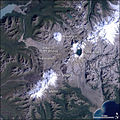
 Katmai NP and Valley of Ten Thousand Smokes from space.jpg 639 × 639; 338 KB
-
 Katmai.jpg 533 × 329; 35 KB
-
 KatmaiCaldera.png 1.086 × 694; 157 KB
-
 KatmaiNP L5 03sep95.jpg 540 × 540; 96 KB
-
 Line0346 - Flickr - NOAA Photo Library.jpg 1.164 × 1.788; 1,2 MB
-
 Looking downriver from Ukak Falls 2 (13542782743).jpg 4.000 × 3.000; 3,69 MB
-
 Looking into Katmai Pass as seen from south side of Falling Mountain (13542907475).jpg 4.896 × 3.264; 4,44 MB
-
 Looking north down the Valley of Ten Thousand Smokes (12292002503).jpg 1.440 × 1.920; 221 KB
-
 Lower end of the Valley of Ten Thousand Smokes (12292001303).jpg 1.440 × 1.080; 86 KB
-
 Lower end of the Valley of Ten Thousand Smokes (2) (12292001613).jpg 1.440 × 1.080; 106 KB
-
 Mageik Volcano from Griggs Visitor Center Panorama (13543103034).jpg 11.066 × 4.008; 11,54 MB
-
 Mount Griggs Valley of Ten Thousand Smokes.jpg 3.264 × 2.448; 1,91 MB
-

-
 MountMageik.jpg 1.024 × 690; 141 KB
-
 Mt Griggs in the Valley of Ten Thousand Smokes (44086396562).jpg 1.080 × 720; 109 KB
-

-
 Novarupta (13543091424).jpg 4.320 × 3.240; 3,94 MB
-
 Novarupta and Baked Mtn. (13542730745).jpg 4.000 × 3.000; 4,13 MB
-
 Novarupta lava dome viewed from Mount Katmai.jpg 1.400 × 936; 1,79 MB
-
 Novarupta.png 1.215 × 521; 108 KB
-
 Outlet Stream of east Mageik Lake (13542805513).jpg 4.000 × 3.000; 3,85 MB
-
 Phreatic explosion crater next to lava flow near Mt. Cerberus (13542833103).jpg 4.000 × 3.000; 4,11 MB
-
 PhreaticCrater.png 596 × 709; 773 KB
-
 River Lethe in the Valley of Ten Thousand Smokes.jpg 1.400 × 936; 1,56 MB
-

-
 Southwest Trident from lateral moraine above the east Mageik lake (13542814603).jpg 4.000 × 3.000; 2,3 MB
-
 Southwestern corner of the Valley of Ten Thousand Smokes (12291844835).jpg 1.440 × 1.080; 95 KB
-
 Summit of Southwest Trident (13542914725).jpg 4.896 × 3.264; 5,1 MB
-
 Summit of Southwest Trident (13543018883).jpg 2.728 × 1.088; 1,31 MB
-
 Ten Thousand Smokes Valley - panoramio (1).jpg 5.616 × 3.480; 5,63 MB
-
 Ten Thousand Smokes Valley - panoramio (2).jpg 5.616 × 3.744; 4,59 MB
-
 Ten Thousand Smokes Valley - panoramio (3).jpg 11.231 × 2.702; 6,03 MB
-
 Ten Thousand Smokes Valley - panoramio.jpg 5.616 × 3.744; 6,07 MB
-
 Tephra ring around Novarupta (13542871345).jpg 4.896 × 3.264; 5,79 MB
-
 Tephra ring around Novarupta 2 08182013 (13543257664).jpg 4.896 × 3.264; 5,77 MB
-
 Tephra ring around Novarupta 3 08172013 (13543178874).jpg 4.896 × 3.264; 5,42 MB
-
 The Confluence (13542760925).jpg 3.456 × 2.592; 2,88 MB
-
 The Gorge of the River Lethe (13542787333).jpg 4.000 × 3.000; 3,1 MB
-
 Ukak Falls in the Valley of Ten Thousand Smokes (30393431788).jpg 3.000 × 2.003; 4,75 MB
-
 Upper VTTS 1 02242015 Patrol Flight (16458697338).jpg 4.896 × 3.264; 2,84 MB
-
 Upper VTTS 5 02242015 Patrol Flight (16460101559).jpg 4.896 × 3.264; 2,24 MB
-
 Valley of 10,000 Smokes NPS Photo J. Hower (48809558653).jpg 3.456 × 2.304; 3,38 MB
-
 Valley of Ten Thousand Smokes banner.jpg 2.100 × 300; 188 KB
-
 Valley of Ten Thousand Smokes from Overlook Cabin.jpg 1.400 × 936; 1,62 MB
-

-
 Valley of Ten Thousand Smokes, Alaska (ASTER).jpg 1.460 × 1.464; 418 KB
-
 Valley of Ten Thousand Smokes, Katmai National Park (10106236035).jpg 6.000 × 3.375; 5,9 MB
-
 Valley of Ten Thousand Smokes, Katmai National Park (10106288236).jpg 6.000 × 3.375; 5,32 MB
-
 Valley of Ten Thousand Smokes, Katmai National Park (10106297443).jpg 6.000 × 3.375; 6,2 MB
-
 Valley of Ten Thousand Smokes, Katmai National Park (10106321303).jpg 6.000 × 3.375; 4,54 MB
-
 Valley of Ten Thousand Smokes. Katmai National Park, Alaska (27478560394).jpg 6.000 × 4.000; 13,87 MB
-
 View up the Valley of Ten Thousand Smokes.jpg 3.264 × 2.448; 2,29 MB
-
 Views from western-most Knife Creek Glacier, Valley of Ten Thousand Smokes (13542747263).jpg 3.648 × 2.736; 2,62 MB
-

-
 VTTS (16162334088).jpg 3.862 × 2.063; 6,86 MB
-

-

-
 Welded tuff along the River Lethe gorge (13542795863).jpg 4.000 × 3.000; 3,38 MB
-
 Western arm of souther VTTS looking towards Mageik Lakes (13542754225).jpg 4.176 × 2.784; 3,47 MB
-
 Wind abraded pumice between Mt. Cerberus and Mt. Mageik (13542846563).jpg 4.000 × 3.000; 3,75 MB
-
 Wind abraided pumice (13543127864).jpg 4.896 × 3.264; 4,43 MB
.jpg)


.jpg)
.jpg)
.jpg)
,_Valley_of_Ten_Thousand_Smokes_(13542891453).jpg)
.jpg)
.jpg)

.jpg)
.jpg)
_(14758408146).jpg)
.jpg)
.jpg)
.jpg)
.jpg)
.jpg)
.jpg)
.jpg)


_(13543039224).jpg)


.jpg)


.jpg)
.jpg)
.jpg)
.jpg)
_(12292001613).jpg)

.jpg)

.jpg)
.jpg)
.jpg)
.jpg)


.jpg)
.jpg)


.jpg)
.jpg)
.jpg)
.jpg)
.jpg)
.jpg)

.jpg)
.jpg)
.jpg)
.jpg)
.jpg)
.jpg)
.jpg)
.jpg)
.jpg)

.jpg)
.jpg)
.jpg)
.jpg)
.jpg)
.jpg)
.jpg)

.jpg)
.jpg)
.jpg)
.jpg)
_(13543032913).jpg)
.jpg)
.jpg)
.jpg)
.jpg)
.jpg)
.jpg)
.jpg)
.jpg)
Kategorien:
- Ignimbrite sheets in the United States
- Volcanism in the Katmai volcanic cluster
- Katmai volcanic cluster in 1912
- Volcano-fluvial landforms
- Katmai volcanic cluster
- Rhyolite in the United States
- 1912 eruption of Mount Katmai
- Visitor attractions of Katmai National Park
- Volcanism of Katmai National Park
- Katmai Caldera in 1912
- Ignimbrites in Alaska
- Eruption products of Katmai Caldera 1912 eruption series