Category:Vent
Zur Navigation springen
Zur Suche springen
Ortschaft in Tirol  | |||||
| Medium hochladen | |||||
| Ist ein(e) |
| ||||
|---|---|---|---|---|---|
| Ort | Sölden, Bezirk Imst, Tirol, Österreich | ||||
| Einwohnerzahl |
| ||||
| Höhe über dem Meeresspiegel |
| ||||
 | |||||
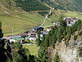
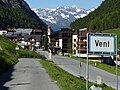
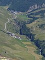
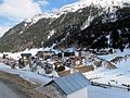
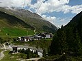
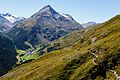
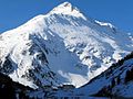
Deutsch: Vent ist ein zur Gemeinde Sölden gehörendes Dorf in den Ötztaler Alpen in Tirol, Österreich.
English: Vent is a village belonging to the municipality of Sölden in the Ötztal Alps, Tyrol, Austria.
Unterkategorien
Es werden 21 von insgesamt 21 Unterkategorien in dieser Kategorie angezeigt:
In Klammern die Anzahl der enthaltenen Kategorien (K), Seiten (S), Dateien (D)
B
- Breslauer Hütte (22 D)
C
- Cyprian-Granbichler-Weg (36 D)
G
- Gasthof Obervent (11 D)
H
K
- Kapelle Vent (6 D)
M
- Mutsbichl (3 D)
N
P
- Pfarrkirche Vent (15 D)
R
- Ramolalm (4 D)
- Rofenkarferner (7 D)
S
- Spiegelbach (Vent) (1 D)
V
- Vent in the 1950s (1 D)
- Vent in the 1960s (5 D)
- Vent in the 1970s (1 D)
- Vent in the 19th century (8 D)
Medien in der Kategorie „Vent“
Folgende 39 Dateien sind in dieser Kategorie, von 39 insgesamt.
-
 Doppelsessellift Wildspitze in Vent, Tirol, Österreich.jpg 5.760 × 3.840; 20,27 MB
-
 Gebirgsdorf Vent in den Ötztaler Alpen (2009-08-22).jpg 3.264 × 2.448; 3,74 MB
-
 Lower skistation Stablein near Vent. This was the end of our walking route. - panoramio.jpg 4.928 × 3.264; 2,46 MB
-
 Niedertalbach in Vent 2020.jpg 4.000 × 3.000; 4,83 MB
-

-
 Rofen Vent Rofental Ramolkamm.jpg 4.000 × 3.000; 4,93 MB
-
 Rofen Vent Rofental.jpg 4.000 × 3.000; 4,88 MB
-
 Rofen Vent W.JPG 3.156 × 2.272; 5,02 MB
-
 Schild an der Pegelmeßstation der Rofenache.jpg 1.600 × 1.200; 503 KB
-

-
 Vent 2015.jpg 4.000 × 3.000; 4,64 MB
-
 Vent 2016, Blick aus Richtung Wildspitze.jpg 5.760 × 3.840; 15,97 MB
-
 Vent 2018.jpg 4.000 × 3.000; 4,84 MB
-
 Vent 2018a.jpg 4.000 × 3.000; 4,58 MB
-
 Vent 2019.jpg 4.000 × 3.000; 4,81 MB
-
 Vent Gesamtansicht 2020.jpg 3.000 × 4.000; 4,24 MB
-
 Vent Heuwiese 2023a.jpg 4.000 × 3.000; 4,77 MB
-
 Vent Hotel Wildspitz.jpg 4.000 × 3.000; 4,9 MB
-
 Vent mit Kapelle.jpg 4.000 × 3.000; 4,83 MB
-
 Vent Niedertal vom Sonnberg.jpg 4.000 × 3.000; 4,86 MB
-
 Vent oberer Teil 2015.jpg 4.000 × 3.000; 4,59 MB
-
 Vent Ortseingang.jpg 4.000 × 3.000; 4,5 MB
-
 Vent Ortsschild SW.jpg 4.000 × 3.000; 4,71 MB
-
 Vent Panorama.jpg 8.960 × 2.414; 6,14 MB
-
 Vent Rofenhöfe.jpg 3.000 × 4.000; 4,21 MB
-
 Vent Stubaier Alpen 2018.jpg 4.000 × 3.000; 4,45 MB
-
 Vent Sued.jpg 1.240 × 930; 428 KB
-
 Vent Süd S 2012.jpg 1.218 × 913; 374 KB
-
 Vent Talkessel.jpg 1.203 × 902; 411 KB
-
 Vent vom Mutsbichl.jpg 4.000 × 3.000; 4,43 MB
-
 Vent, Winter 2014.JPG 4.000 × 3.000; 1,65 MB
-
 Vent2.jpg 3.264 × 2.448; 3,74 MB
-
 Vent3.jpg 3.264 × 2.448; 3,75 MB
-
 Vent4.jpg 3.264 × 2.448; 3,47 MB
-
 Vent5.jpg 3.264 × 2.448; 3,83 MB
-
 Venter Ache mit Vent,jpg.jpg 4.000 × 3.000; 4,68 MB
-
 Venter Höhenweg Sommer 2016.jpg 5.760 × 3.840; 17,79 MB
-
 VentNorden.jpg 1.240 × 930; 366 KB
-
 Widum Vent1 FoNo.jpg 4.000 × 3.000; 5,02 MB

.jpg)


at_the_Southend_of_the_Otztal_near_Italy_-_panoramio.jpg)


