Category:Walton on the Wolds
Aller à la navigation
Aller à la recherche
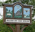
English: Walton on the Wolds is a village and civil parish in the Charnwood district of Leicestershire, England. It has a population of around 250. It is near to Burton on the Wolds and Barrow upon Soar. It was the location of one series of Boon, starring Neil Morrissey. The series used the Tudor house, Kings Cote, as Boon's house.
localité britannique du comté anglais de Leicestershire | |||||
| Téléverser des médias | |||||
| Nature de l’élément | |||||
|---|---|---|---|---|---|
| Lieu | Charnwood, Leicestershire, Midlands de l'Est, Angleterre | ||||
 | |||||
Sous-catégories
Cette catégorie comprend 2 sous-catégories, dont les 2 ci-dessous.
Média dans la catégorie « Walton on the Wolds »
Cette catégorie comprend 167 fichiers, dont les 167 ci-dessous.
-
 10 Loughborough Road, Walton on the Wolds (geograph 7365787).jpg 1 024 × 768 ; 275 kio
-
 40-34 Loughborough Road, Walton - geograph.org.uk - 2712386.jpg 1 280 × 953 ; 316 kio
-
 Anchor Inn - geograph.org.uk - 86871.jpg 347 × 223 ; 17 kio
-
 Avenue in Manor Farm grounds - geograph.org.uk - 2712401.jpg 1 280 × 959 ; 551 kio
-
 Barn full of bales at Middle Farm - geograph.org.uk - 4931047.jpg 640 × 446 ; 90 kio
-
 Barn north of Six Hills Road - geograph.org.uk - 4931051.jpg 640 × 469 ; 87 kio
-
-
 Bend in Black Lane - geograph.org.uk - 878195.jpg 640 × 480 ; 101 kio
-
 Big Lane near Walton on the Wolds - geograph.org.uk - 132222.jpg 640 × 427 ; 146 kio
-
 Big Lane near Walton on the Wolds - geograph.org.uk - 878156.jpg 640 × 458 ; 96 kio
-
 Big Lane towards Walton on the Wolds - geograph.org.uk - 878167.jpg 640 × 468 ; 102 kio
-
 Black Lane - geograph.org.uk - 2712413.jpg 1 280 × 938 ; 298 kio
-
 Black Lane in Walton on the Wolds - geograph.org.uk - 878201.jpg 640 × 565 ; 112 kio
-
 Black Lane into Walton on the Wolds - geograph.org.uk - 3037425.jpg 640 × 480 ; 91 kio
-
 Black Lane near Walton on the Wolds - geograph.org.uk - 878171.jpg 640 × 490 ; 65 kio
-
 Black Lane near Walton on the Wolds - geograph.org.uk - 878197.jpg 640 × 559 ; 117 kio
-
 Black Lane, Walton on the Wolds - geograph.org.uk - 132217.jpg 640 × 480 ; 141 kio
-
 Bridge across Fishpool Brook - geograph.org.uk - 878162.jpg 480 × 640 ; 120 kio
-
 Burton Wolds in Leicestershire - geograph.org.uk - 882897.jpg 640 × 446 ; 69 kio
-
 Church of St Mary, Walton on the Wolds (geograph 7523588).jpg 3 776 × 2 520 ; 3,97 Mio
-
 Cotes Road - geograph.org.uk - 1773686.jpg 640 × 410 ; 67 kio
-
 Cotes Road crosses Walton Brook - geograph.org.uk - 5827376.jpg 640 × 482 ; 88 kio
-
 Cotes Road heading south - geograph.org.uk - 3037353.jpg 640 × 480 ; 79 kio
-
 Cotes Road passes Ryecroft Farm entrance - geograph.org.uk - 2103936.jpg 640 × 470 ; 63 kio
-
 Cotes Road towards Barrow - geograph.org.uk - 2103937.jpg 640 × 463 ; 77 kio
-
 Cradock's Ashes - geograph.org.uk - 3038672.jpg 640 × 480 ; 103 kio
-
 Daffodils by the entrance to Meadow View - geograph.org.uk - 4931052.jpg 640 × 518 ; 137 kio
-
 Derelict house on Walton Lane - geograph.org.uk - 2787761.jpg 640 × 579 ; 118 kio
-
 Driveway to Foxhill Farm - geograph.org.uk - 2787762.jpg 640 × 580 ; 100 kio
-
 Entrance to a field of rape - geograph.org.uk - 5015731.jpg 640 × 460 ; 131 kio
-
 Farmland - geograph.org.uk - 6307642.jpg 1 600 × 900 ; 445 kio
-
 Farmland, Coteswick Farm - geograph.org.uk - 3037350.jpg 640 × 480 ; 82 kio
-
 Farmland, Walton on the Wolds - geograph.org.uk - 3037423.jpg 640 × 480 ; 67 kio
-
 Field north of Six Hills Road - geograph.org.uk - 2787784.jpg 640 × 483 ; 92 kio
-
 Field north of Six Hills Road - geograph.org.uk - 4931053.jpg 640 × 442 ; 73 kio
-
 Field west of Cotes Road - geograph.org.uk - 5827377.jpg 640 × 450 ; 69 kio
-
 Fields by Six Hills Road - geograph.org.uk - 2097206.jpg 640 × 471 ; 90 kio
-
 Fields next to Fieldfares - geograph.org.uk - 2787756.jpg 640 × 484 ; 77 kio
-
 Fields north of Six Hills Road - geograph.org.uk - 2787792.jpg 640 × 443 ; 58 kio
-
 Fields south of Six Hills Road - geograph.org.uk - 2787794.jpg 640 × 490 ; 86 kio
-
 Fingerpost, The Green, Walton - geograph.org.uk - 2712362.jpg 945 × 1 280 ; 363 kio
-
 Folly in the woods - geograph.org.uk - 2712407.jpg 1 280 × 959 ; 503 kio
-
 Footpath across Manor Farm grounds - geograph.org.uk - 2712403.jpg 1 280 × 959 ; 424 kio
-
 Footpath to Burton on the Wolds - geograph.org.uk - 2712387.jpg 1 280 × 959 ; 306 kio
-
 Footpath to Six Hills Road - geograph.org.uk - 5018206.jpg 640 × 480 ; 124 kio
-
 Footpath to the north - geograph.org.uk - 5015708.jpg 640 × 455 ; 77 kio
-
 Footpath to Walton on the Wolds - geograph.org.uk - 5018207.jpg 640 × 495 ; 93 kio
-
 Footpath towards Burton on the Wolds - geograph.org.uk - 3037429.jpg 640 × 480 ; 63 kio
-
 Footpath towards Wymeswold - geograph.org.uk - 2787785.jpg 640 × 502 ; 98 kio
-
 Frisky cattle - geograph.org.uk - 5015709.jpg 640 × 442 ; 78 kio
-
 Gap between fields - geograph.org.uk - 2787786.jpg 640 × 470 ; 91 kio
-
-
 Gateway on south side of Six Hills Road - geograph.org.uk - 4931561.jpg 640 × 429 ; 74 kio
-
 Gateway to track west of Cotes Road - geograph.org.uk - 5823584.jpg 640 × 480 ; 69 kio
-
 Grazing land, Walton on the Wolds - geograph.org.uk - 3037430.jpg 640 × 480 ; 66 kio
-
 Grazing near Walton on the Wolds - geograph.org.uk - 3038591.jpg 640 × 480 ; 81 kio
-
 Grazing sheep, Walton - geograph.org.uk - 2712351.jpg 1 280 × 945 ; 443 kio
-
 Harvest time by New Lane - geograph.org.uk - 2787770.jpg 640 × 480 ; 91 kio
-
 Herding sheep on Six Hills Road - geograph.org.uk - 2787787.jpg 640 × 508 ; 93 kio
-
 Herding sheep on Six Hills Road - geograph.org.uk - 2787788.jpg 640 × 525 ; 93 kio
-
 Hill Farm, Walton - geograph.org.uk - 2712350.jpg 1 280 × 943 ; 361 kio
-
 Hill Farmhouse, Walton - geograph.org.uk - 2712356.jpg 1 280 × 981 ; 299 kio
-
 Houses on Walton Lane - geograph.org.uk - 2787757.jpg 640 × 480 ; 85 kio
-
 Ivy House Farmhouse - geograph.org.uk - 2712357.jpg 1 280 × 949 ; 264 kio
-
 Junction of New Lane and Loughborough Road - geograph.org.uk - 2787771.jpg 640 × 529 ; 153 kio
-
 Kings Cote, Walton - geograph.org.uk - 2712377.jpg 1 280 × 959 ; 358 kio
-
 Late sun over Charnwood - geograph.org.uk - 2712409.jpg 1 280 × 762 ; 107 kio
-
 Lizard catching a fly - geograph.org.uk - 2787768.jpg 640 × 389 ; 134 kio
-
 Loughborough Road eastwards - geograph.org.uk - 2787772.jpg 640 × 518 ; 143 kio
-
 Loughborough Road enters Walton on the Wolds - geograph.org.uk - 882909.jpg 640 × 425 ; 68 kio
-
 Loughborough Road heading west - geograph.org.uk - 3038592.jpg 640 × 480 ; 70 kio
-
 Loughborough Road in Walton on the Wolds - geograph.org.uk - 878202.jpg 640 × 500 ; 82 kio
-
 Loughborough Road in Walton on the Wolds - geograph.org.uk - 878204.jpg 640 × 460 ; 84 kio
-
 Loughborough Road westwards - geograph.org.uk - 2787773.jpg 640 × 584 ; 130 kio
-
 Meadow View of Six Hills Road - geograph.org.uk - 4931054.jpg 640 × 420 ; 82 kio
-
 Merevale Cottages, Walton - geograph.org.uk - 2712360.jpg 1 280 × 957 ; 250 kio
-
 Modern parkland at Manor Farm - geograph.org.uk - 2712405.jpg 1 280 × 959 ; 354 kio
-
 Muck heap in field - geograph.org.uk - 4931562.jpg 640 × 462 ; 98 kio
-
 Muddy field corner - geograph.org.uk - 2103939.jpg 640 × 526 ; 126 kio
-
 New Lane - geograph.org.uk - 2787774.jpg 640 × 479 ; 109 kio
-
 New Lane eastwards - geograph.org.uk - 2787779.jpg 640 × 538 ; 156 kio
-
 New Lane westwards - geograph.org.uk - 2787780.jpg 640 × 516 ; 99 kio
-
 New Lane-Black Lane junction - geograph.org.uk - 2787778.jpg 640 × 435 ; 116 kio
-

-
 Old cross base, Walton - geograph.org.uk - 2712394.jpg 953 × 1 280 ; 495 kio
-
 Old Rectory garden gate - geograph.org.uk - 2712390.jpg 1 280 × 945 ; 399 kio
-

-
 Postbox and telephone kiosk, Walton - geograph.org.uk - 2712374.jpg 959 × 1 280 ; 333 kio
-
 Public footpath to Walton on the Wolds - geograph.org.uk - 882918.jpg 640 × 484 ; 103 kio
-
 Ridge and Furrow - geograph.org.uk - 150726.jpg 640 × 427 ; 114 kio
-
 Road Junction nr Barrow Hill - geograph.org.uk - 1773658.jpg 640 × 427 ; 75 kio
-
 Road towards Six Hills - geograph.org.uk - 2712143.jpg 1 280 × 959 ; 179 kio
-
 Saint Mary's church - geograph.org.uk - 4966828.jpg 800 × 600 ; 106 kio
-
 School Hill - geograph.org.uk - 2712388.jpg 1 280 × 959 ; 232 kio
-
 Shuttlewoods Farm entrance - geograph.org.uk - 4931055.jpg 640 × 434 ; 50 kio
-
 Shuttlewoods Farm sign - geograph.org.uk - 4931056.jpg 640 × 427 ; 65 kio
-
 Signs on footpath marker - geograph.org.uk - 5018211.jpg 640 × 607 ; 140 kio
-
 Six Hills Road - geograph.org.uk - 2712352.jpg 1 280 × 928 ; 417 kio
-
 Six Hills Road - geograph.org.uk - 2712354.jpg 1 280 × 959 ; 304 kio
-
 Six Hills Road - geograph.org.uk - 6307646.jpg 1 600 × 900 ; 536 kio
-
 Six Hills Road at Three Oaks - geograph.org.uk - 4931048.jpg 640 × 488 ; 80 kio
-
 Six Hills Road eastwards - geograph.org.uk - 2787781.jpg 640 × 529 ; 181 kio
-
 Six Hills Road eastwards - geograph.org.uk - 2787789.jpg 640 × 528 ; 131 kio
-
 Six Hills Road eastwards - geograph.org.uk - 2787795.jpg 640 × 591 ; 104 kio
-
 Six Hills Road eastwards - geograph.org.uk - 2787798.jpg 640 × 535 ; 89 kio
-
 Six Hills Road eastwards after some rain - geograph.org.uk - 4931563.jpg 640 × 452 ; 79 kio
-
 Six Hills Road in Walton on the Wolds - geograph.org.uk - 878211.jpg 640 × 461 ; 91 kio
-
 Six Hills Road near Walton on the Wolds - geograph.org.uk - 882901.jpg 640 × 543 ; 141 kio
-
 Six Hills Road passes Middle Farm - geograph.org.uk - 4931049.jpg 640 × 454 ; 117 kio
-

-
 Six Hills Road passes Top Town Plantation - geograph.org.uk - 2787782.jpg 640 × 444 ; 118 kio
-
 Six Hills Road towards Middle Farm - geograph.org.uk - 2097208.jpg 640 × 492 ; 125 kio
-
 Six Hills Road towards Three Oaks - geograph.org.uk - 4931050.jpg 640 × 435 ; 72 kio
-
 Six Hills Road towards Walton on the Wolds - geograph.org.uk - 4931043.jpg 640 × 478 ; 142 kio
-
 Six Hills Road towards White Lodge Farm - geograph.org.uk - 2787790.jpg 640 × 520 ; 83 kio
-
 Six Hills Road westwards - geograph.org.uk - 2787783.jpg 640 × 486 ; 121 kio
-
 Six Hills Road westwards - geograph.org.uk - 2787791.jpg 640 × 480 ; 119 kio
-
 Six Hills Road westwards - geograph.org.uk - 2787796.jpg 640 × 466 ; 81 kio
-
 Six Hills Road westwards after some rain - geograph.org.uk - 4931564.jpg 640 × 454 ; 67 kio
-

-

-
 South of Walton Lane - geograph.org.uk - 2787764.jpg 640 × 489 ; 85 kio
-
 Streaky field - geograph.org.uk - 2787775.jpg 640 × 536 ; 141 kio
-
 The Anchor Inn, Walton - geograph.org.uk - 2712372.jpg 1 280 × 959 ; 309 kio
-
 The Anchor Inn, Walton on the Wolds - geograph.org.uk - 3037427.jpg 640 × 480 ; 76 kio
-
 The Green, Walton - geograph.org.uk - 2712358.jpg 1 280 × 959 ; 313 kio
-
 The Old Rectory - geograph.org.uk - 2712392.jpg 1 280 × 926 ; 210 kio
-
 The red door - geograph.org.uk - 2712383.jpg 1 280 × 921 ; 259 kio
-
 Top Farm - geograph.org.uk - 4931057.jpg 640 × 480 ; 90 kio
-
 Towards Six Hills - geograph.org.uk - 2097207.jpg 640 × 401 ; 81 kio
-
 Towards Three Oaks - geograph.org.uk - 2097205.jpg 640 × 370 ; 51 kio
-
 Towards Walton Thorns farm buildings - geograph.org.uk - 5018212.jpg 640 × 470 ; 66 kio
-
 Track and gateway by Top Town Plantation - geograph.org.uk - 4931044.jpg 640 × 511 ; 88 kio
-
 Track towards wood west of Cotes Road - geograph.org.uk - 5823586.jpg 640 × 480 ; 63 kio
-
 View from Nottingham Road - geograph.org.uk - 550893.jpg 640 × 453 ; 120 kio
-
 View from Six Hills Road - geograph.org.uk - 2787793.jpg 640 × 445 ; 67 kio
-
 View towards Walton Thorns Farm - geograph.org.uk - 2712156.jpg 1 280 × 959 ; 230 kio
-
 Village Hall, Walton on the Wolds - geograph.org.uk - 3037433.jpg 640 × 480 ; 61 kio
-
 Village sign, Walton on the Wolds - geograph.org.uk - 2712414.jpg 932 × 1 280 ; 334 kio
-
 Walton Grange, Walton on the Wolds - geograph.org.uk - 16795.jpg 640 × 453 ; 132 kio
-
 Walton Lane - geograph.org.uk - 1773672.jpg 640 × 410 ; 54 kio
-
 Walton Lane - geograph.org.uk - 2787769.jpg 640 × 480 ; 93 kio
-
 Walton Lane eastwards - geograph.org.uk - 2787758.jpg 640 × 527 ; 91 kio
-
 Walton Lane eastwards - geograph.org.uk - 2787765.jpg 640 × 528 ; 79 kio
-
 Walton Lane heading east - geograph.org.uk - 3037349.jpg 640 × 480 ; 79 kio
-
 Walton Lane westwards - geograph.org.uk - 2787759.jpg 640 × 539 ; 96 kio
-
 Walton Lane westwards - geograph.org.uk - 2787766.jpg 640 × 604 ; 85 kio
-
 Walton Lane westwards - geograph.org.uk - 2787776.jpg 640 × 498 ; 96 kio
-
 Walton on the Wolds - geograph.org.uk - 2712348.jpg 1 280 × 948 ; 411 kio
-
 Walton on the Wolds burial Ground - geograph.org.uk - 2787777.jpg 640 × 477 ; 96 kio
-
 Walton on the Wolds in Leicestershire - geograph.org.uk - 878192.jpg 640 × 417 ; 83 kio
-
 Walton on the Wolds in Leicestershire - geograph.org.uk - 878198.jpg 640 × 469 ; 108 kio
-
 Walton on the Wolds village sign - geograph.org.uk - 878207.jpg 640 × 585 ; 127 kio
-
 Walton Thorns farm buildings - geograph.org.uk - 5018213.jpg 640 × 458 ; 53 kio
-
 Walton Village Hall - geograph.org.uk - 2712385.jpg 1 280 × 948 ; 263 kio
-
 White Lodge Farm - geograph.org.uk - 4931058.jpg 640 × 330 ; 32 kio
-
 Woodland near Walton Grange - geograph.org.uk - 3037344.jpg 480 × 640 ; 151 kio
-
 Yew for the Millennium - geograph.org.uk - 2712396.jpg 1 280 × 959 ; 455 kio
-
 Farmland near Walton on the Wolds - geograph.org.uk - 132230.jpg 640 × 427 ; 166 kio
-
 Farmland near Walton-in-the-Wolds - geograph.org.uk - 148133.jpg 640 × 427 ; 86 kio
-
 Fishpool Brook near Walton on the Wolds - geograph.org.uk - 132236.jpg 640 × 427 ; 130 kio
-

-
 Road Junction near Walton on the Wolds - geograph.org.uk - 16793.jpg 640 × 473 ; 131 kio
-
 Shuttlewood's Farm near Walton-on-the-Wolds - geograph.org.uk - 148144.jpg 640 × 480 ; 120 kio
-
 Six Hills Road near Walton-on-the-Wolds - geograph.org.uk - 148149.jpg 640 × 427 ; 98 kio
-
 Walton Lodge, Walton on the Wolds - geograph.org.uk - 16796.jpg 640 × 425 ; 99 kio
-
 Walton-on-the-Wolds, Leicestershire - geograph.org.uk - 148152.jpg 640 × 427 ; 120 kio
.jpg)


.jpg)


