Category:Warkworth, Northumberland
Aller à la navigation
Aller à la recherche
village britannique  | |||||
| Téléverser des médias | |||||
| Nature de l’élément | |||||
|---|---|---|---|---|---|
| Lieu |
| ||||
| site officiel | |||||
 | |||||
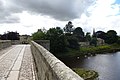
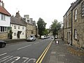
English: Warkworth is a village in Northumberland, England. It is probably best known for its well-preserved medieval castle, church and hermitage. The population of Warkworth was 1,493 in 2001. The village is situated in a loop of the River Coquet, about south of the Scottish border. An ancient bridge of two arches crosses the river at Warkworth, with a fortified gateway on the road mounting to the castle. (→Warkworth, Northumberland)
Italiano: Warkworth è un paese di 1.600 abitanti della contea del Northumberland, in Inghilterra. Situato nella stretta ansa del fiume Coquet è sede di un castello di fondazione sassone la cui pianta è sovrapponibile a quella del castello di Cuasso in provincia di Varese in Italia. (→Warkworth (Northumberland))
Nederlands: Warkworth is een plaats en civil parish in het bestuurlijke gebied Northumberland, in het Engelse graafschap Northumberland met 1.493 inwoners. (→Warkworth (Northumberland))
Polski: Warkworth – wieś w Anglii, w hrabstwie Northumberland. Leży 42 km na północ od miasta Newcastle upon Tyne i 438 km na północ od Londynu. Miejscowość liczy 1493 mieszkańców. (→Warkworth (Northumberland))

Sous-catégories
Cette catégorie comprend 17 sous-catégories, dont les 17 ci-dessous.
B
- Warkworth Beach, Northumberland (21 F)
- Birling, Northumberland (4 F)
- Brotherwick (1 F)
C
- Cemetery Chapel, Warkworth (4 F)
G
- Gloster Hill, Northumberland (2 F)
H
- Warkworth Hermitage (19 F)
- Warkworth House Hotel (2 F)
L
M
- Morwick (26 F)
P
R
- Warkworth railway station (15 F)
S
Média dans la catégorie « Warkworth, Northumberland »
Cette catégorie comprend 929 fichiers, dont les 200 ci-dessous.
(page précédente) (page suivante)-
 "Hurry up - the tide's coming in" - geograph.org.uk - 5041746.jpg 640 × 480 ; 201 kio
-
 ... post office in Warkworth, Northumberland. (2902054653).jpg 960 × 1 280 ; 193 kio
-
 1 and 2, Dial Place.jpg 4 451 × 2 967 ; 8,49 Mio
-
 1, Castle Terrace.jpg 1 019 × 1 359 ; 269 kio
-
 1, The Stanners.jpg 4 539 × 3 025 ; 10,17 Mio
-
 10, 11 And 12, Bridge Street.jpg 2 744 × 2 057 ; 923 kio
-
 13, Dial Place.jpg 5 568 × 3 712 ; 15,71 Mio
-
 14, Castle Street (1).jpg 2 592 × 3 456 ; 1,6 Mio
-
 14, The Butts.jpg 4 255 × 2 837 ; 7,36 Mio
-
 15, Bridge Street.jpg 2 848 × 4 272 ; 5,17 Mio
-
 16 And 16A, Castle Street.jpg 1 697 × 2 263 ; 894 kio
-
 16, Dial Place.jpg 3 712 × 5 568 ; 15,2 Mio
-
 18 ^ 19 The Butts, Warkworth - geograph.org.uk - 5877820.jpg 1 024 × 768 ; 228 kio
-
 19, Dial Place.jpg 1 362 × 1 817 ; 403 kio
-
 20, Dial Place.jpg 1 653 × 2 203 ; 600 kio
-
 21, Bridge Street.jpg 1 606 × 2 140 ; 686 kio
-
 25 And 26, Castle Street.jpg 2 902 × 2 176 ; 1,16 Mio
-
 30 And 31, Castle Street.jpg 2 525 × 1 894 ; 840 kio
-
 33, Castle Street.jpg 3 617 × 2 713 ; 1,51 Mio
-
 37, Castle Street.jpg 3 232 × 2 423 ; 1,49 Mio
-
 4, Castle Street.jpg 3 283 × 2 462 ; 1,97 Mio
-
 4, Dial Place.jpg 3 236 × 2 428 ; 1,55 Mio
-
 43, Castle Street.jpg 3 332 × 2 499 ; 1,63 Mio
-
 44, Castle Street.jpg 3 188 × 2 390 ; 1,28 Mio
-
 46, Castle Street.jpg 3 099 × 2 324 ; 1,49 Mio
-
 47, Castle Street.jpg 2 509 × 1 882 ; 930 kio
-
 4A, Castle Street.jpg 2 814 × 2 110 ; 1,31 Mio
-
 5, Castle Street.jpg 2 876 × 2 157 ; 1,29 Mio
-
 5A, Castle Street.jpg 1 945 × 2 592 ; 918 kio
-
 6 And 7, Dial Place.jpg 2 592 × 3 455 ; 1,67 Mio
-
 6, Castle Street.jpg 2 036 × 2 714 ; 1,07 Mio
-
 8 Bridge Street, Warkworth (2022-03-29) 1.jpg 5 568 × 3 712 ; 15,4 Mio
-
 8 Bridge Street, Warkworth (2022-03-29) 2.jpg 3 712 × 5 568 ; 14,64 Mio
-
 8 Bridge Street, Warkworth (2022-03-29) 3.jpg 5 568 × 3 712 ; 16,03 Mio
-
 A coble at Amble - geograph.org.uk - 2589007.jpg 1 280 × 856 ; 120 kio
-
 A crop of oats north of Togston - geograph.org.uk - 4681987.jpg 2 048 × 1 536 ; 1,38 Mio
-
 A Heron keeps vigil on the River Coquet, Warkworth - geograph.org.uk - 4101581.jpg 4 608 × 3 456 ; 3,66 Mio
-
 A view into the village - geograph.org.uk - 4220659.jpg 4 302 × 2 740 ; 2,6 Mio
-
 A1068 at Warkworth village boundary - geograph.org.uk - 5835092.jpg 1 024 × 729 ; 100 kio
-
 A1068 Castle Street and Warkworth Castle - geograph.org.uk - 5835117.jpg 1 024 × 764 ; 110 kio
-
 A1068 going north - geograph.org.uk - 4041547.jpg 2 592 × 1 936 ; 2,04 Mio
-
 A1068 in Birling - geograph.org.uk - 5835126.jpg 1 024 × 731 ; 124 kio
-
 A1068 towards Alnmouth - geograph.org.uk - 3049825.jpg 640 × 480 ; 94 kio
-
 Above Castle Street, Warkworth - geograph.org.uk - 5878919.jpg 1 024 × 767 ; 213 kio
-
 Access road for caravan site to the A1068 with bridleway status - geograph.org.uk - 2880032.jpg 3 648 × 2 736 ; 2,65 Mio
-
 Access to the beach alongside Salters Burn - geograph.org.uk - 2880100.jpg 3 648 × 2 736 ; 3,14 Mio
-
 Across the River Coquet from Warkworth Church - geograph.org.uk - 951440.jpg 640 × 480 ; 117 kio
-
 Allotment at The Butts, Warkworth - geograph.org.uk - 2918618.jpg 1 024 × 768 ; 393 kio
-
 Along the coast path - geograph.org.uk - 3596335.jpg 640 × 428 ; 94 kio
-
 Along the Coquet to Warkworth - geograph.org.uk - 4220709.jpg 4 155 × 2 010 ; 1,34 Mio
-
 Amble - Northumberland - geograph.org.uk - 2847094.jpg 640 × 480 ; 67 kio
-
 Amble Harbour and River Coquet - geograph.org.uk - 4163706.jpg 4 000 × 2 248 ; 3,95 Mio
-
 Amble Harbour and River Coquet - geograph.org.uk - 4163712.jpg 4 000 × 2 248 ; 3,96 Mio
-
 Amble Harbour and River Coquet - geograph.org.uk - 4163748.jpg 4 000 × 2 248 ; 4,08 Mio
-
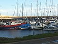
 Amble Marina - geograph.org.uk - 2003181.jpg 1 280 × 960 ; 250 kio
-
 Amble Marina - geograph.org.uk - 2587724.jpg 1 280 × 856 ; 242 kio
-
 Amble Marina - geograph.org.uk - 2589492.jpg 1 280 × 856 ; 188 kio
-
 Amble Marina - geograph.org.uk - 3596124.jpg 640 × 428 ; 112 kio
-
 Amble Marina - geograph.org.uk - 4158503.jpg 640 × 428 ; 83 kio
-
 Amble Marina - geograph.org.uk - 4369825.jpg 1 024 × 678 ; 198 kio
-
 Amble Marina - geograph.org.uk - 4477024.jpg 640 × 480 ; 438 kio
-
 Amble Marina - geograph.org.uk - 5463121.jpg 1 600 × 1 200 ; 662 kio
-
 Amble Marina ^ view towards Warkworth Castle - geograph.org.uk - 6013394.jpg 5 184 × 2 920 ; 5,93 Mio
-
 An unsealed road - geograph.org.uk - 2955635.jpg 640 × 360 ; 232 kio
-
 Anti-tank defences, Birling Links - geograph.org.uk - 5510830.jpg 1 024 × 756 ; 172 kio
-
 Anti-tank defences, near Warkworth - geograph.org.uk - 5820078.jpg 1 600 × 1 067 ; 456 kio
-
 Approach to Warkworth - geograph.org.uk - 4575961.jpg 800 × 533 ; 199 kio
-
 Approaching a coastal caravan park - geograph.org.uk - 4660560.jpg 2 048 × 1 536 ; 868 kio
-
 Arable field at Brotherwick - geograph.org.uk - 5892359.jpg 2 000 × 1 333 ; 602 kio
-
 Arable field at Morwick - geograph.org.uk - 5890446.jpg 2 000 × 1 333 ; 489 kio
-
 Arable field east of Low Buston Hall (geograph 6000984).jpg 2 000 × 1 333 ; 572 kio
-
 Arable field north of Warkworth - geograph.org.uk - 4660566.jpg 2 048 × 1 536 ; 1,04 Mio
-
 Arable field north west of New Barns - geograph.org.uk - 5890472.jpg 2 000 × 1 333 ; 333 kio
-
 Arable field on the edge of Warkworth - geograph.org.uk - 4682027.jpg 2 048 × 1 536 ; 1,14 Mio
-
 Arable field south of Brotherwick - geograph.org.uk - 5892354.jpg 2 000 × 1 333 ; 475 kio
-
 Arable field south of Warkworth - geograph.org.uk - 4682022.jpg 2 048 × 1 536 ; 1,06 Mio
-
 Arable field west of Coquet Moor House - geograph.org.uk - 5892322.jpg 2 000 × 1 333 ; 423 kio
-
 Arable fields near Northfield farm - geograph.org.uk - 3279799.jpg 1 600 × 1 250 ; 268 kio
-
 Arable land at Mill Cottage - geograph.org.uk - 5997610.jpg 2 000 × 1 333 ; 424 kio
-
 Arable land at Shortridge Hall - geograph.org.uk - 6000957.jpg 1 857 × 1 237 ; 2,07 Mio
-
 Arable land north east of East House - geograph.org.uk - 5896085.jpg 1 637 × 1 091 ; 888 kio
-
 Arable land, south of Alnmouth - geograph.org.uk - 4575993.jpg 800 × 533 ; 170 kio
-
 Artwork by the Coquet - geograph.org.uk - 1637418.jpg 640 × 479 ; 83 kio
-
 Atmospheric weir on the River Coquet - geograph.org.uk - 4057530.jpg 640 × 480 ; 59 kio
-
 Avenue of Trees - geograph.org.uk - 2978143.jpg 640 × 427 ; 125 kio
-
 B1068 at Warkworth - geograph.org.uk - 5431971.jpg 4 896 × 3 672 ; 6,16 Mio
-
 Barclays Bank (1).jpg 3 456 × 4 608 ; 3,62 Mio
-
 Barn at New Barns Farm - geograph.org.uk - 1805921.jpg 640 × 480 ; 83 kio
-
 Barn or farm shed - geograph.org.uk - 3002997.jpg 1 600 × 1 200 ; 417 kio
-
 Beach and Caravan Site - geograph.org.uk - 4288231.jpg 1 066 × 800 ; 114 kio
-
 Beach and dunes at Birling Links - geograph.org.uk - 5930632.jpg 640 × 480 ; 79 kio
-
 Beach and Stormy Sea - geograph.org.uk - 4288239.jpg 1 066 × 800 ; 134 kio
-
 Beach and view towards Birling Carrs - geograph.org.uk - 4287798.jpg 1 066 × 800 ; 128 kio
-
 Beach at Birling Links - geograph.org.uk - 4287769.jpg 1 066 × 800 ; 143 kio
-
 Beach below Castles Dike - geograph.org.uk - 4287786.jpg 1 066 × 800 ; 138 kio
-
 Beach below the golf course - geograph.org.uk - 3596307.jpg 640 × 428 ; 103 kio
-
 Beach between Alnmouth and Warkworth - geograph.org.uk - 3596315.jpg 640 × 428 ; 116 kio
-
 Beach north of Birling Carrs - geograph.org.uk - 4660561.jpg 2 048 × 1 536 ; 557 kio
-
 Beach south of Birling Carrs - geograph.org.uk - 4660564.jpg 2 048 × 1 536 ; 639 kio
-
 Beal Bank (A1068) towards Amble - geograph.org.uk - 3049795.jpg 640 × 480 ; 93 kio
-
 Beal Bank - geograph.org.uk - 2588981.jpg 1 280 × 857 ; 152 kio
-
 Beal Bank towards Warkworth - geograph.org.uk - 5928178.jpg 640 × 415 ; 96 kio
-
 Beal Bank towards Warkworth - geograph.org.uk - 5928191.jpg 640 × 409 ; 57 kio
-
 Behind the houses, Warkworth - geograph.org.uk - 931267.jpg 640 × 480 ; 120 kio
-
 Below the north side of Warkworth Castle - geograph.org.uk - 2918674.jpg 1 024 × 767 ; 268 kio
-
 Below the Weir - River Coquet, Warkworth - geograph.org.uk - 2765121.jpg 768 × 1 024 ; 142 kio
-
 Between Alnmouth and Warkworth - geograph.org.uk - 3596316.jpg 640 × 428 ; 121 kio
-
 Between the rocks at Birling Carrs - geograph.org.uk - 3047201.jpg 1 600 × 1 202 ; 135 kio
-
 Birling Carrs - geograph.org.uk - 2982115.jpg 4 000 × 3 000 ; 2,69 Mio
-
 Birling Carrs - geograph.org.uk - 3047192.jpg 1 600 × 1 147 ; 186 kio
-
 Birling Carrs - geograph.org.uk - 4288221.jpg 1 066 × 800 ; 125 kio
-
 Birling Carrs - geograph.org.uk - 446942.jpg 640 × 418 ; 86 kio
-
 Birling Carrs - geograph.org.uk - 5266069.jpg 640 × 427 ; 103 kio
-
 Birling Links - geograph.org.uk - 2849140.jpg 1 600 × 1 109 ; 197 kio
-
 Birling Links - geograph.org.uk - 2982108.jpg 4 000 × 3 000 ; 2,67 Mio
-
 Birling Links - geograph.org.uk - 3277798.jpg 1 600 × 1 200 ; 246 kio
-
 Birling Links - geograph.org.uk - 3500342.jpg 3 872 × 2 592 ; 3,69 Mio
-
 Birling Links sea in the distance - geograph.org.uk - 3233714.jpg 640 × 427 ; 91 kio
-
 Black headed gull - geograph.org.uk - 535832.jpg 640 × 480 ; 114 kio
-
 Black-headed Gull, Chroicocephalus ridibundus - geograph.org.uk - 3023270.jpg 1 600 × 1 495 ; 135 kio
-
 Blocked doorway, St Lawrence Church, Warkworth - geograph.org.uk - 5878093.jpg 1 024 × 768 ; 382 kio
-
 Blocked doorway, St Lawrence Church, Warkworth - geograph.org.uk - 5878098.jpg 768 × 1 024 ; 275 kio
-

-
 Boat in front of the castle - geograph.org.uk - 3596269.jpg 640 × 428 ; 79 kio
-
 Boat on Coquet - geograph.org.uk - 1536977.jpg 572 × 640 ; 64 kio
-
 Boats and Kayakers - geograph.org.uk - 3596135.jpg 640 × 428 ; 103 kio
-
 Boats at Amble - geograph.org.uk - 2588902.jpg 1 280 × 856 ; 180 kio
-
 Boats in the marina - geograph.org.uk - 4019821.jpg 2 592 × 1 936 ; 934 kio
-
 Boats in the marina - geograph.org.uk - 5064991.jpg 640 × 427 ; 106 kio
-
 Boats in Warkworth Harbour - geograph.org.uk - 5928243.jpg 640 × 384 ; 73 kio
-
 Bottom of Castle Street, Warkworth - geograph.org.uk - 2918782.jpg 1 024 × 768 ; 212 kio
-
 Bottom of Castle Street, Warkworth - geograph.org.uk - 2918803.jpg 1 024 × 769 ; 220 kio
-
 Bracken and thistles on edge of pasture - geograph.org.uk - 3632919.jpg 1 600 × 1 342 ; 409 kio
-
 Brambles near Birling - geograph.org.uk - 2955631.jpg 640 × 360 ; 249 kio
-
 Bridge across the Burn - geograph.org.uk - 2765257.jpg 2 178 × 1 189 ; 1,47 Mio
-
 Bridge across the Burn - Warkworth - geograph.org.uk - 2765264.jpg 1 704 × 2 272 ; 2,02 Mio
-
 Bridge crossing the East Coast Mainline at Buston Barns - geograph.org.uk - 5997636.jpg 2 000 × 1 333 ; 496 kio
-
 Bridge crossing the East Coast Mainline on Warkworth Moor - geograph.org.uk - 5892349.jpg 1 333 × 2 000 ; 354 kio
-
 Bridge End House - geograph.org.uk - 2126552.jpg 2 000 × 1 696 ; 608 kio
-
 Bridge End House, Warkworth - geograph.org.uk - 4220675.jpg 3 940 × 2 524 ; 1,75 Mio
-
 Bridge End House, Warkworth - geograph.org.uk - 5877835.jpg 1 024 × 768 ; 257 kio
-
 Bridge End House.jpg 3 704 × 2 778 ; 2,04 Mio
-
 Bridge in Warkworth - geograph.org.uk - 3596302.jpg 640 × 428 ; 96 kio
-
 Bridge over Guilders Burn - geograph.org.uk - 3370627.jpg 1 600 × 1 200 ; 511 kio
-
 Bridge over the Coquet - geograph.org.uk - 4559335.jpg 428 × 640 ; 120 kio
-
 Bridge over the East Coast Main line - geograph.org.uk - 3578245.jpg 1 600 × 1 077 ; 196 kio
-
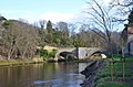
 Bridge over the river Coquet, at Warkworth - geograph.org.uk - 735121.jpg 640 × 426 ; 79 kio
-
 Bridge over the River Coquet, Warkworth - geograph.org.uk - 4660573.jpg 2 048 × 1 536 ; 953 kio
-
 Bridge Street, Warkworth - geograph.org.uk - 1199102.jpg 640 × 480 ; 70 kio
-
 Bridge Street, Warkworth - geograph.org.uk - 2156007.jpg 640 × 480 ; 141 kio
-
 Bridge Street, Warkworth - geograph.org.uk - 2156045.jpg 480 × 640 ; 62 kio
-
 Bridge Street, Warkworth - geograph.org.uk - 3049810.jpg 640 × 480 ; 70 kio
-
 Bridge Street, Warkworth - geograph.org.uk - 5820001.jpg 1 125 × 1 600 ; 412 kio
-
 Bridges over the River Coquet, Warkworth - geograph.org.uk - 4370064.jpg 1 024 × 678 ; 225 kio
-
 Bridleway and Ford Near Morwick - geograph.org.uk - 3728733.jpg 4 608 × 3 456 ; 3,48 Mio
-
 Bridleway inland from Buston Links - geograph.org.uk - 3499701.jpg 3 872 × 2 592 ; 3,91 Mio
-
 Bridleway near Hart Law - geograph.org.uk - 2477113.jpg 640 × 480 ; 134 kio
-
 Bridleway through Birling Carrs caravan site - geograph.org.uk - 3499774.jpg 3 872 × 2 592 ; 3,24 Mio
-
 Bridleway to Amble - geograph.org.uk - 4201716.jpg 640 × 480 ; 94 kio
-
 Bridleway to the coast - geograph.org.uk - 3694975.jpg 4 330 × 3 046 ; 1,53 Mio
-
 Bridleway towards Warkworth Golf Club - geograph.org.uk - 5064576.jpg 640 × 427 ; 100 kio
-
 Brotherwick from the East Coast railway - geograph.org.uk - 3659620.jpg 880 × 1 024 ; 121 kio
-
 Bunker on Warkworth Golf Course - geograph.org.uk - 5510823.jpg 1 024 × 768 ; 183 kio
-
 Burn in the woods - geograph.org.uk - 3351869.jpg 1 600 × 1 200 ; 643 kio
-
 Bush with starlings - geograph.org.uk - 5041739.jpg 640 × 480 ; 404 kio
-
 Buston Barns - geograph.org.uk - 4289131.jpg 1 066 × 800 ; 282 kio
-
 Buston Links - geograph.org.uk - 2982139.jpg 4 000 × 3 000 ; 2,68 Mio
-
 By Shortridge Hall - geograph.org.uk - 4554033.jpg 800 × 533 ; 267 kio
-
 Byway heading south - geograph.org.uk - 3408712.jpg 640 × 480 ; 42 kio
-
 Canada geese on the Coquet - geograph.org.uk - 3694697.jpg 4 343 × 2 935 ; 2,85 Mio
-
 Canoeing on the River Coquet - geograph.org.uk - 5158209.jpg 1 066 × 800 ; 149 kio
-
 Canoeing on the River Coquet - geograph.org.uk - 5158212.jpg 1 066 × 800 ; 184 kio
-
 Car park entrance - geograph.org.uk - 5064581.jpg 640 × 427 ; 108 kio
-
 Car parks ahead - geograph.org.uk - 5064577.jpg 640 × 427 ; 104 kio
-
 Caravan park at Coquet Moor House - geograph.org.uk - 5892312.jpg 2 000 × 1 333 ; 403 kio
-
 Caravan Site above Birling Carrs - geograph.org.uk - 1201486.jpg 640 × 480 ; 74 kio
-
 Caravan site at Birling Carrs - geograph.org.uk - 5930738.jpg 640 × 442 ; 77 kio
-
 Carved wood panel by River Coquet Weir - geograph.org.uk - 2918032.jpg 1 024 × 768 ; 221 kio
-
 Castle Brew House, Warkworth - geograph.org.uk - 5431951.jpg 4 896 × 3 672 ; 4,94 Mio
-
 Castle entrance - geograph.org.uk - 5320008.jpg 2 560 × 1 920 ; 1,35 Mio
-
 Castle Street - geograph.org.uk - 5065116.jpg 640 × 427 ; 106 kio
-
 Castle Street in Warkworth - geograph.org.uk - 4755304.jpg 800 × 531 ; 125 kio
-
 Castle Street in Warkworth - geograph.org.uk - 5930407.jpg 640 × 408 ; 108 kio
-
 Castle Street, Warkworth - geograph.org.uk - 1680198.jpg 853 × 1 280 ; 405 kio
-
 Castle Street, Warkworth - geograph.org.uk - 2122837.jpg 2 000 × 1 340 ; 530 kio
-
 Castle Street, Warkworth - geograph.org.uk - 2156038.jpg 640 × 480 ; 129 kio
-
 Castle Street, Warkworth - geograph.org.uk - 3049804.jpg 640 × 480 ; 72 kio
-
 Castle Street, Warkworth - geograph.org.uk - 4220703.jpg 4 320 × 3 240 ; 3,16 Mio
-
 Castle Street, Warkworth - geograph.org.uk - 4370050.jpg 1 024 × 678 ; 226 kio
-
 Castle Street, Warkworth - geograph.org.uk - 4576018.jpg 800 × 533 ; 205 kio
-
 Castle Street, Warkworth - geograph.org.uk - 4675332.jpg 2 048 × 1 536 ; 1,16 Mio
-
 Castle Street, Warkworth - geograph.org.uk - 4755290.jpg 1 024 × 680 ; 284 kio
-
 Castle Street, Warkworth - geograph.org.uk - 4842735.jpg 1 024 × 678 ; 170 kio
-
 Castle Street, Warkworth, 1995 - geograph.org.uk - 1724817.jpg 640 × 428 ; 97 kio
-
 Castle Street, Warkworth, Northumberland - geograph.org.uk - 3052301.jpg 1 024 × 762 ; 187 kio
-
 Castle Street, Warkworth, Northumberland - geograph.org.uk - 3071896.jpg 1 024 × 753 ; 189 kio
-
 Castle Terrace and the Sun Hotel, Warkworth - geograph.org.uk - 3500439.jpg 3 872 × 2 592 ; 3,04 Mio
-
 Castle Terrace, Warkworth - geograph.org.uk - 4101531.jpg 4 608 × 3 456 ; 3,07 Mio
-
 Castlegate House (1).jpg 2 018 × 1 514 ; 812 kio
-
 Castles Dike - geograph.org.uk - 2848233.jpg 1 600 × 1 200 ; 299 kio

.jpg)


.jpg)


_1.jpg)
_2.jpg)
_3.jpg)


.jpg)


.jpg)


_towards_Amble_-_geograph.org.uk_-_3049795.jpg)


.jpg)
