Category:Wehrspeicher Wodarg
Zur Navigation springen
Zur Suche springen

53°45′4″N 13°20′1″E / 53.75111°N 13.33361°E
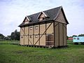
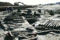
Deutsch: Nachbau eines bei Wodarg ausgegrabenen Wehrspeichers (Kemlade) in Klempenow im Landkreis Demmin.
| Objektposition | | Karte mit allen Koordinaten: OpenStreetMap |
|---|
| |||||
| Medium hochladen | |||||
| Ist ein(e) | |||||
|---|---|---|---|---|---|
| Ort | Werder, Landkreis Mecklenburgische Seenplatte, Mecklenburg-Vorpommern, Deutschland | ||||
 | |||||
Medien in der Kategorie „Wehrspeicher Wodarg“
Folgende 16 Dateien sind in dieser Kategorie, von 16 insgesamt.
-
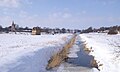 Grosser Landgraben Klempenow Winter.JPG 3.008 × 1.801; 2,69 MB
-
 KemladeWodarg.jpg 1.280 × 960; 227 KB
-
 KemladeWodarg1.jpg 1.280 × 960; 190 KB
-
 KemladeWodarg2.jpg 1.280 × 960; 183 KB
-
 KemladeWodarg3.jpg 1.280 × 960; 219 KB
-
 KemladeWodarg4.jpg 1.280 × 960; 140 KB
-
 KemladeWodarg5.jpg 800 × 600; 328 KB
-
 KemladeWodarg6.jpg 800 × 600; 376 KB
-
 KemladeWodarg7.jpg 800 × 600; 388 KB
-
 KemladeWodarg8.jpg 800 × 600; 384 KB
-
 Klempenow DM Nachbau Kemlade 01.jpg 2.000 × 3.008; 560 KB
-
 Klempenow-Kemlade-Wodarg-22-08-2008-235.jpg 467 × 338; 122 KB
-
 Tollense-Grosser-Landgraben-VI-2007-356.jpg 1.024 × 768; 643 KB
-
 Wehrspeicher Wodarg Hochwasser August 2011.JPG 2.848 × 2.144; 1,51 MB
-
 Wodarg-Wehrspeicher.jpg 500 × 333; 126 KB
-
 Wodarg9.jpg 800 × 600; 63 KB


