Category:Westcott Barton
Aller à la navigation
Aller à la recherche
localité britannique du comté anglais d'Oxfordshire  | |||||
| Téléverser des médias | |||||
| Nature de l’élément | |||||
|---|---|---|---|---|---|
| Lieu | West Oxfordshire, Oxfordshire, Angleterre du Sud-Est, Angleterre | ||||
 | |||||
English: Westcott Barton, also spelt Wescot Barton or Wescote Barton, is a village and civil parish on the River Dorn in West Oxfordshire about south of Banbury. Westcott Barton's main area of housing is on the eastern boundary of the parish and contiguous with the village of Middle Barton in the neighbouring parish of Steeple Barton. The toponym has three modern spellings: the civil parish is "Westcot Barton", the village tends to be spelt "Westcott Barton" and a large house in the village is called "Westcote Barton" Lodge.
Sous-catégories
Cette catégorie comprend seulement la sous-catégorie ci-dessous.
C
Média dans la catégorie « Westcott Barton »
Cette catégorie comprend 8 fichiers, dont les 8 ci-dessous.
-
 Enstone Road - geograph.org.uk - 6232962.jpg 640 × 480 ; 93 kio
-
 Farmland north of Middle Barton - geograph.org.uk - 5193027.jpg 640 × 480 ; 205 kio
-
 Ford on Fox Lane, Middle Barton - geograph.org.uk - 5193016.jpg 640 × 480 ; 240 kio
-
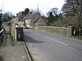 Westcott Barton, The Enstone Road Bridge - geograph.org.uk - 360994.jpg 640 × 480 ; 102 kio
-
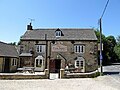 Westcot Barton-The Fox Inn - geograph.org.uk - 6194123.jpg 1 600 × 1 200 ; 553 kio
-
 Old Milestone (geograph 6114623).jpg 965 × 1 425 ; 252 kio
-
 Westcott Barton - geograph.org.uk - 6194119.jpg 1 600 × 1 200 ; 658 kio
-
 WestcottBarton TheFox.JPG 3 000 × 2 000 ; 820 kio


.jpg)

