Category:Wittersham
Aller à la navigation
Aller à la recherche
English: Wittersham is a village and civil parish, part of the Isle of Oxney, south of Ashford in Kent, South East England, near Tenterden.
village britannique  | |||||
| Téléverser des médias | |||||
| Nature de l’élément | |||||
|---|---|---|---|---|---|
| Lieu | Ashford (borough), Kent, Angleterre du Sud-Est, Angleterre | ||||
| Superficie |
| ||||
| Réputé identique à | Wittersham (page en doublon, paroisse civile) | ||||
 | |||||
Sous-catégories
Cette catégorie comprend 9 sous-catégories, dont les 9 ci-dessous.
E
- Ewe and Lamb, Wittersham (5 F)
J
O
S
- The Swan, Wittersham (6 F)
T
- The Stocks, Wittersham (2 F)
W
- Wittersham Road railway station (56 F)
- Wittersham Village Sign (7 F)
- Wittersham War Memorial (6 F)
Média dans la catégorie « Wittersham »
Cette catégorie comprend 461 fichiers, dont les 200 ci-dessous.
(page précédente) (page suivante)-
 29, The Street - geograph.org.uk - 3022379.jpg 640 × 430 ; 63 kio
-
 39, The Street - geograph.org.uk - 3024285.jpg 640 × 430 ; 68 kio
-
 8, The Street - geograph.org.uk - 3022371.jpg 640 × 430 ; 96 kio
-
 A bend in the Reading Sewer - geograph.org.uk - 4018267.jpg 4 000 × 3 000 ; 4,34 Mio
-
 A converted chapel, Wittersham - geograph.org.uk - 3022368.jpg 640 × 430 ; 76 kio
-
 A gap in the orchard, Wittersham - geograph.org.uk - 3557054.jpg 1 024 × 768 ; 192 kio
-
 A lane enters Sussex from Kent - geograph.org.uk - 1744150.jpg 3 072 × 2 304 ; 2,32 Mio
-
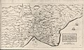 A map of Romney Marsh (1662).jpg 7 554 × 4 505 ; 21,73 Mio
-
 A small disused quarry, Isle of Oxney - geograph.org.uk - 3028330.jpg 640 × 430 ; 76 kio
-
 A small pond - geograph.org.uk - 3013162.jpg 640 × 430 ; 86 kio
-
 A small stream flowing off The Isle of Oxney - geograph.org.uk - 3028342.jpg 640 × 430 ; 140 kio
-
 A small valley, The Isle of Oxney - geograph.org.uk - 3028339.jpg 640 × 430 ; 72 kio
-
 Acton Lane - geograph.org.uk - 5785009.jpg 1 024 × 684 ; 259 kio
-
 Acton Lane and Rushgreen Wood - geograph.org.uk - 1979516.jpg 1 600 × 1 061 ; 393 kio
-
 Apple orchard - geograph.org.uk - 3024323.jpg 640 × 430 ; 101 kio
-
 Approaching Blackwall Bridge - geograph.org.uk - 3029807.jpg 640 × 430 ; 93 kio
-
 Archer's Post - geograph.org.uk - 1744020.jpg 3 072 × 2 304 ; 1,58 Mio
-
 B2082 across Rother Levels - geograph.org.uk - 3010201.jpg 640 × 430 ; 53 kio
-
 B2082 Rye Road - geograph.org.uk - 6084791.jpg 1 024 × 684 ; 241 kio
-
 B2082 Rye Road - geograph.org.uk - 6084795.jpg 1 024 × 684 ; 281 kio
-
 B2082, Isle of Oxney - geograph.org.uk - 3016247.jpg 640 × 430 ; 82 kio
-
 B2082, Isle of Oxney - geograph.org.uk - 3016252.jpg 640 × 430 ; 84 kio
-
 Barn at Acton Farm - geograph.org.uk - 4488992.jpg 4 000 × 2 667 ; 2,91 Mio
-
 Barn by Lordings - geograph.org.uk - 2877358.jpg 640 × 480 ; 98 kio
-
 Barrowsland Farm from Reading Sewer - geograph.org.uk - 388781.jpg 640 × 479 ; 152 kio
-
 Bate's Gill Wood - geograph.org.uk - 3024322.jpg 640 × 430 ; 139 kio
-
 Bate's Gill Wood - geograph.org.uk - 3024333.jpg 640 × 430 ; 75 kio
-
 Bate's Gill Wood - geograph.org.uk - 3024336.jpg 640 × 430 ; 71 kio
-
 Bates Gill - geograph.org.uk - 1744087.jpg 2 304 × 3 072 ; 3,14 Mio
-
 Beehive Cottage - geograph.org.uk - 3021949.jpg 640 × 430 ; 90 kio
-
 Bend in the road from Wittersham - geograph.org.uk - 2511353.jpg 2 256 × 1 496 ; 891 kio
-
 Bend, River Rother - geograph.org.uk - 3029825.jpg 640 × 430 ; 64 kio
-
 Bend, River Rother - geograph.org.uk - 3032009.jpg 640 × 430 ; 66 kio
-
 Black Barn Farm - geograph.org.uk - 3016236.jpg 640 × 430 ; 66 kio
-
 Black Barn Farm - geograph.org.uk - 3016240.jpg 640 × 430 ; 72 kio
-
 Black Barn House - geograph.org.uk - 1743069.jpg 3 072 × 2 304 ; 2,28 Mio
-
 Blackbrook Farm, Swan Street, Wittersham, Kent - geograph.org.uk - 967402.jpg 640 × 427 ; 101 kio
-
 Blackwall Bridge - geograph.org.uk - 1763358.jpg 1 600 × 1 061 ; 430 kio
-
 Blackwall Bridge - geograph.org.uk - 3029808.jpg 640 × 430 ; 68 kio
-
 Blackwall Bridge - geograph.org.uk - 3029819.jpg 640 × 430 ; 57 kio
-
 Blackwall East Pumping Station - geograph.org.uk - 6213968.jpg 640 × 480 ; 58 kio
-
 Blackwall Gauging Station - geograph.org.uk - 6213973.jpg 480 × 640 ; 81 kio
-
 Blackwall North Pumping Station - geograph.org.uk - 4033830.jpg 4 912 × 3 264 ; 4,4 Mio
-
 Bridleway alongside Wittersham Cemetery - geograph.org.uk - 3557061.jpg 1 024 × 768 ; 235 kio
-
 Bridleway and footpath junction near the River Rother - geograph.org.uk - 1993766.jpg 3 072 × 2 304 ; 1,73 Mio
-
 Bridleway to Sheeplands Plantation - geograph.org.uk - 1743085.jpg 3 072 × 2 304 ; 2,52 Mio
-
 Cattle grazing - geograph.org.uk - 4080639.jpg 3 648 × 2 736 ; 3,53 Mio
-
 Cattle on Rother Levels - geograph.org.uk - 5784606.jpg 1 024 × 768 ; 336 kio
-
 Cattle, Rother Levels - geograph.org.uk - 3029835.jpg 640 × 430 ; 63 kio
-
 Cemetery in Wittersham - geograph.org.uk - 4032700.jpg 4 912 × 3 264 ; 6,73 Mio
-
 Comb Bank - geograph.org.uk - 1743065.jpg 3 072 × 2 304 ; 2,23 Mio
-
 Comb Wood - geograph.org.uk - 1991791.jpg 3 072 × 2 304 ; 1,71 Mio
-
 Comb Wood - geograph.org.uk - 3016229.jpg 640 × 430 ; 49 kio
-
 Comb Wood - geograph.org.uk - 3016232.jpg 640 × 430 ; 48 kio
-
 Communication centre, Wittersham - geograph.org.uk - 3020400.jpg 640 × 430 ; 95 kio
-

-
 Coombe Lands - geograph.org.uk - 3020340.jpg 640 × 430 ; 72 kio
-
 Corkswood Farm Pumping Station on the River Rother - geograph.org.uk - 1993855.jpg 3 072 × 2 304 ; 1,02 Mio
-
 Cottage on The Street - geograph.org.uk - 3022361.jpg 640 × 430 ; 71 kio
-
 Cottage, The Street - geograph.org.uk - 3022372.jpg 640 × 430 ; 67 kio
-
 Cottages on The Street, Wittersham - geograph.org.uk - 4032675.jpg 4 912 × 3 264 ; 5,71 Mio
-
 Cottages, The Street - geograph.org.uk - 3022381.jpg 640 × 430 ; 60 kio
-
 Countryside on the Isle of Oxney - geograph.org.uk - 3024330.jpg 640 × 430 ; 77 kio
-
 Cows by River Rother - geograph.org.uk - 4468875.jpg 1 600 × 1 200 ; 787 kio
-
 Cows by River Rother - geograph.org.uk - 4468881.jpg 1 600 × 1 200 ; 881 kio
-
 Crop Fields near Reading Sewer - geograph.org.uk - 2511404.jpg 2 256 × 1 496 ; 879 kio
-
 Damage to Potman's Heath Channel Flood Wall - geograph.org.uk - 1744426.jpg 2 304 × 3 072 ; 3,02 Mio
-
 Ditch, Rother Levels - geograph.org.uk - 3028369.jpg 640 × 430 ; 77 kio
-
 Drain beside B2086 - geograph.org.uk - 6133270.jpg 3 264 × 2 448 ; 4,01 Mio
-
 Drain near Rother Cottage - geograph.org.uk - 4469004.jpg 1 600 × 1 200 ; 718 kio
-
 Drain on Rother Levels - geograph.org.uk - 3010206.jpg 640 × 430 ; 82 kio
-
 Drain on Rother Levels - geograph.org.uk - 5784602.jpg 1 024 × 768 ; 232 kio
-
 Drain, Rother Levels - geograph.org.uk - 3010205.jpg 640 × 430 ; 90 kio
-
 Drainage channel from Valley Farm - geograph.org.uk - 1744351.jpg 3 072 × 2 304 ; 1,66 Mio
-
 Drainage channels, Rother levels - geograph.org.uk - 3013153.jpg 640 × 386 ; 68 kio
-
 Drainage ditch, Rother Levels - geograph.org.uk - 3029802.jpg 640 × 404 ; 60 kio
-
 Driveway, Kingsgate Farm - geograph.org.uk - 3016205.jpg 640 × 430 ; 119 kio
-
 Entering Wittersham - geograph.org.uk - 3020327.jpg 640 × 430 ; 96 kio
-
 Entrance to Budds House - geograph.org.uk - 2910741.jpg 2 256 × 1 496 ; 925 kio
-
 Farm Barns near the River Rother - geograph.org.uk - 1744261.jpg 3 072 × 2 304 ; 1,62 Mio
-
 Farm gate - geograph.org.uk - 3020306.jpg 640 × 430 ; 136 kio
-
 Farm Outbuilding near Blackbrook Farm - geograph.org.uk - 388349.jpg 640 × 479 ; 179 kio
-
 Farm track - geograph.org.uk - 3016243.jpg 640 × 430 ; 95 kio
-
 Farmland by the B2082 - geograph.org.uk - 3010196.jpg 640 × 430 ; 48 kio
-
 Farmland north-east of Timber Wood - geograph.org.uk - 3564235.jpg 1 024 × 768 ; 141 kio
-
 Farmland on the Rother Levels - geograph.org.uk - 3013184.jpg 640 × 430 ; 57 kio
-
 Farmland south of Small Hythe - geograph.org.uk - 3010192.jpg 640 × 430 ; 59 kio
-
 Farmland, Isle of Oxney - geograph.org.uk - 3016186.jpg 640 × 430 ; 61 kio
-
 Feeding Time - geograph.org.uk - 388746.jpg 640 × 479 ; 138 kio
-
 Fern Stream near Tophill Farm - geograph.org.uk - 1997016.jpg 2 304 × 3 072 ; 2,49 Mio
-
 Fern valley in Church Wood - geograph.org.uk - 1991786.jpg 2 304 × 3 072 ; 1,69 Mio
-
 Field near Comb Wood - geograph.org.uk - 2511460.jpg 2 256 × 1 496 ; 907 kio
-
 Field near Palstre Court Farm - geograph.org.uk - 2511400.jpg 2 256 × 1 496 ; 760 kio
-
 Field of Sheep - geograph.org.uk - 2585511.jpg 2 256 × 1 496 ; 822 kio
-
 Field separating Timber Wood and Comb Wood - geograph.org.uk - 3564215.jpg 1 024 × 768 ; 161 kio
-
 Field with rusted farm equipment - geograph.org.uk - 2511386.jpg 2 256 × 1 496 ; 818 kio
-
 Field, The Isle of Oxney - geograph.org.uk - 3028323.jpg 640 × 430 ; 101 kio
-
 Fields near Blackbrook Farm - geograph.org.uk - 2511344.jpg 2 256 × 1 496 ; 895 kio
-
 Fields towards the Rother Valley - geograph.org.uk - 2910753.jpg 2 256 × 1 496 ; 911 kio
-
 Fishing on the River Rother - geograph.org.uk - 2661334.jpg 2 256 × 1 496 ; 878 kio
-
 Flooded area near Potman's Heath Channel - geograph.org.uk - 1744365.jpg 3 072 × 1 728 ; 1,02 Mio
-
 Flooded Maytham's Sewer - geograph.org.uk - 1744495.jpg 3 041 × 1 667 ; 1,06 Mio
-
 Flowering rape - geograph.org.uk - 3020338.jpg 640 × 329 ; 64 kio
-
 Footbridge and kissing gate near Tophill Farm - geograph.org.uk - 1997009.jpg 2 304 × 3 072 ; 2,2 Mio
-
 Footbridge in Church Wood - geograph.org.uk - 1992910.jpg 2 304 × 3 072 ; 1,51 Mio
-
 Footbridge, HWLT - geograph.org.uk - 3028364.jpg 640 × 430 ; 76 kio
-
 Footpath across a hay field, Wittersham - geograph.org.uk - 3557017.jpg 1 024 × 768 ; 177 kio
-
 Footpath alongside the Reading Sewer - geograph.org.uk - 4018135.jpg 4 000 × 3 000 ; 4,37 Mio
-
 Footpath alongside the Reading Sewer - geograph.org.uk - 4018216.jpg 4 000 × 3 000 ; 3,97 Mio
-
 Footpath beside Church Wood - geograph.org.uk - 1991807.jpg 3 072 × 2 304 ; 1,49 Mio
-
 Footpath crossing an apple orchard - geograph.org.uk - 3557047.jpg 1 024 × 768 ; 199 kio
-
 Footpath gate, path through broad-bean field - geograph.org.uk - 4033801.jpg 4 912 × 3 264 ; 4,89 Mio
-
 Footpath in College Wood - geograph.org.uk - 1993709.jpg 3 072 × 2 304 ; 2 Mio
-
 Footpath junction beside Church Wood - geograph.org.uk - 1992933.jpg 3 072 × 2 304 ; 2,33 Mio
-
 Footpath junction in woodland near Bate's Gill - geograph.org.uk - 3557030.jpg 1 024 × 768 ; 213 kio
-
 Footpath Junction near Bates Gill - geograph.org.uk - 1744083.jpg 3 072 × 2 304 ; 2,88 Mio
-
 Footpath junction near Ham Green - geograph.org.uk - 1993735.jpg 3 072 × 2 304 ; 1,45 Mio
-
 Footpath junction near Hurst Farm - geograph.org.uk - 1993687.jpg 3 072 × 2 304 ; 2,27 Mio
-
 Footpath junction near Owley - geograph.org.uk - 1991822.jpg 3 072 × 2 304 ; 1,23 Mio
-
 Footpath marker - geograph.org.uk - 3029827.jpg 640 × 430 ; 81 kio
-
 Footpath marker, Sussex Border Path - geograph.org.uk - 3032021.jpg 640 × 430 ; 73 kio
-
 Footpath off Poplar Rd - geograph.org.uk - 3020353.jpg 640 × 430 ; 92 kio
-
 Footpath off the High Weald Landscape Trail - geograph.org.uk - 3028313.jpg 640 × 430 ; 113 kio
-
 Footpath off The Street - geograph.org.uk - 3024303.jpg 640 × 430 ; 102 kio
-
 Footpath off The Street - geograph.org.uk - 4489001.jpg 4 000 × 3 000 ; 2,97 Mio
-
 Footpath sign, B2082 - geograph.org.uk - 3010190.jpg 640 × 430 ; 46 kio
-
 Footpath stile in Church Wood - geograph.org.uk - 3564259.jpg 1 024 × 768 ; 210 kio
-
 Footpath through Kingsgate Farm - geograph.org.uk - 4080633.jpg 3 648 × 2 736 ; 4,68 Mio
-
 Footpath to Church Wood - geograph.org.uk - 1992935.jpg 3 072 × 2 304 ; 2,11 Mio
-
 Footpath to College Wood - geograph.org.uk - 1993720.jpg 3 072 × 2 304 ; 1,52 Mio
-
 Footpath to The Stocks - geograph.org.uk - 1997040.jpg 3 072 × 2 304 ; 1,59 Mio
-
 Footpath to Wittersham - geograph.org.uk - 1991834.jpg 3 072 × 2 304 ; 1,61 Mio
-
 Footpath to Wittersham Church - geograph.org.uk - 1993679.jpg 3 072 × 2 304 ; 1,15 Mio
-
 Footpath to Wittersham's east end - geograph.org.uk - 3564251.jpg 1 024 × 768 ; 160 kio
-
 Forge Meads - geograph.org.uk - 3020404.jpg 640 × 430 ; 65 kio
-
 Former course of the River Rother, Small Hythe - geograph.org.uk - 2497785.jpg 4 000 × 3 000 ; 3,96 Mio
-
 Gate beside B2086 - geograph.org.uk - 6133261.jpg 3 264 × 2 448 ; 3,94 Mio
-
 Gate beside the River Rother Flood Wall - geograph.org.uk - 1744192.jpg 3 072 × 2 304 ; 1,77 Mio
-
 Gate by River Rother - geograph.org.uk - 4468885.jpg 1 600 × 1 200 ; 969 kio
-
 Gate in a hedge - geograph.org.uk - 3013207.jpg 640 × 430 ; 58 kio
-
 Gate to College Wood - geograph.org.uk - 1993698.jpg 3 072 × 2 304 ; 1,24 Mio
-
 Gate, High Weald Landscape Trail - geograph.org.uk - 3024338.jpg 640 × 430 ; 108 kio
-
 Gate, Isle of Oxney - geograph.org.uk - 3016220.jpg 640 × 392 ; 101 kio
-
 Gate, Sussex Border Path - geograph.org.uk - 3029843.jpg 640 × 430 ; 77 kio
-
 Gate, Sussex Border Path - geograph.org.uk - 3032005.jpg 640 × 430 ; 65 kio
-
 Gate, Sussex Border Path - geograph.org.uk - 3032016.jpg 640 × 430 ; 77 kio
-
 Gateway to Rother Cottage - geograph.org.uk - 3028404.jpg 640 × 430 ; 92 kio
-
 Green pond at the northern tip of Church Wood - geograph.org.uk - 3564252.jpg 1 024 × 768 ; 197 kio
-
 Hall House - geograph.org.uk - 1993740.jpg 3 072 × 2 304 ; 1,45 Mio
-
 Heading for Blackwall Bridge - geograph.org.uk - 3029803.jpg 640 × 430 ; 84 kio
-
 High Weald from south of Small Hythe - geograph.org.uk - 3943097.jpg 640 × 480 ; 77 kio
-
 High Weald Landscape Trail - geograph.org.uk - 3013173.jpg 640 × 430 ; 65 kio
-
 High Weald Landscape Trail - geograph.org.uk - 3016213.jpg 640 × 430 ; 91 kio
-
 High Weald Landscape Trail - geograph.org.uk - 3016216.jpg 640 × 430 ; 111 kio
-
 High Weald Landscape Trail - geograph.org.uk - 3016224.jpg 640 × 430 ; 75 kio
-
 High Weald Landscape Trail - geograph.org.uk - 3016255.jpg 640 × 430 ; 82 kio
-
 High Weald Landscape Trail - geograph.org.uk - 3024321.jpg 640 × 430 ; 105 kio
-
 High Weald Landscape Trail - geograph.org.uk - 3028326.jpg 640 × 430 ; 112 kio
-
 High Weald Landscape Trail off B2082 - geograph.org.uk - 3016249.jpg 640 × 430 ; 65 kio
-
 High Weald Landscape Trail through an orchard near Wittersham - geograph.org.uk - 1744039.jpg 3 072 × 2 304 ; 3,04 Mio
-
 High Weald Landscape Trail through an orchard to Wittersham - geograph.org.uk - 1744060.jpg 3 072 × 2 304 ; 3,58 Mio
-
 High Weald Landscape Trail to Kingsgate Farm - geograph.org.uk - 3016199.jpg 640 × 430 ; 123 kio
-
 High Weald Landscape Trail west of Ham Green - geograph.org.uk - 3208222.jpg 2 048 × 1 536 ; 468 kio
-
 High Weald Landscape Trail, Rother Levels - geograph.org.uk - 3010207.jpg 640 × 430 ; 53 kio
-
 Historic house - geograph.org.uk - 4488991.jpg 3 582 × 2 687 ; 2,7 Mio
-
 House on Poplar Rd - geograph.org.uk - 3020349.jpg 640 × 388 ; 101 kio
-
 Houses in The Street, Wittersham - geograph.org.uk - 4055791.jpg 4 000 × 3 000 ; 3,89 Mio
-
 HWLT climbing onto The Isle of Oxney - geograph.org.uk - 3013198.jpg 640 × 430 ; 66 kio
-
 In the centre of Wittersham - geograph.org.uk - 4055758.jpg 4 000 × 3 000 ; 4,32 Mio
-
 In the Rother Valley - geograph.org.uk - 3028348.jpg 640 × 430 ; 62 kio
-
 Junction of Drainage Channels - geograph.org.uk - 1744826.jpg 3 072 × 1 728 ; 1,34 Mio
-
 Junction on B2082 - geograph.org.uk - 5784975.jpg 1 024 × 768 ; 245 kio
-
 Kent border, Rye Road - geograph.org.uk - 4468914.jpg 1 600 × 1 200 ; 922 kio
-
 Kings Mill - geograph.org.uk - 3024302.jpg 640 × 430 ; 63 kio
-
 Kingsgate Farm - geograph.org.uk - 3016203.jpg 640 × 430 ; 101 kio
-
 Kingsgate Farm - geograph.org.uk - 3016206.jpg 640 × 430 ; 90 kio
-
 Kingsgate Farm, Isle of Oxney - geograph.org.uk - 3013225.jpg 640 × 430 ; 71 kio
-
 Lambs playing, Isle of Oxney - geograph.org.uk - 3013220.jpg 640 × 430 ; 91 kio
-
 Lane by Rother Cottage - geograph.org.uk - 3028386.jpg 640 × 430 ; 66 kio
-
 Lane on The Rother Levels - geograph.org.uk - 3028384.jpg 640 × 430 ; 77 kio
-
 Lane to Blackwall Bridge - geograph.org.uk - 3028409.jpg 640 × 430 ; 90 kio
-
 Lane to Kingsgate Farm - geograph.org.uk - 5784983.jpg 1 024 × 768 ; 274 kio
-
 Lloyds Green - geograph.org.uk - 3020360.jpg 640 × 430 ; 60 kio
-
 Lloyds Green, Wittersham - geograph.org.uk - 3564265.jpg 1 024 × 768 ; 137 kio
-
 Looking towards houses in Swan Street - geograph.org.uk - 3557024.jpg 1 024 × 768 ; 173 kio
-
 New plantings by the Sewage Works - geograph.org.uk - 3028361.jpg 640 × 430 ; 101 kio
-
 Newbridge Farm - geograph.org.uk - 3035375.jpg 640 × 430 ; 69 kio
-
 Newmill Channel - geograph.org.uk - 388848.jpg 640 × 468 ; 115 kio
-
 Oast House - geograph.org.uk - 4468986.jpg 1 600 × 1 200 ; 843 kio
-
 Oast House - geograph.org.uk - 4488997.jpg 2 834 × 3 779 ; 2,9 Mio
-
 Oilseed rape - geograph.org.uk - 3020315.jpg 640 × 430 ; 73 kio
-
 Oilseed rape by Wittersham Rd - geograph.org.uk - 3020334.jpg 640 × 430 ; 129 kio
-
 Old pump in a field - geograph.org.uk - 4033815.jpg 4 912 × 3 264 ; 4,41 Mio
-
 Old Queens - geograph.org.uk - 3024294.jpg 640 × 430 ; 70 kio
-
 Old Queens, Wittersham - geograph.org.uk - 5822969.jpg 4 896 × 3 672 ; 6,02 Mio
-
 Orchard - geograph.org.uk - 3024306.jpg 640 × 430 ; 80 kio
-
 Orchard - geograph.org.uk - 3024318.jpg 640 × 430 ; 100 kio
-
 Orchard by the High Weald Landscape Trail - geograph.org.uk - 3024317.jpg 640 × 430 ; 85 kio
-
 Orchard by The Street - geograph.org.uk - 4488994.jpg 4 000 × 3 000 ; 4,94 Mio
-
 Orchard near Wittersham - geograph.org.uk - 3024311.jpg 640 × 430 ; 73 kio


.jpg)


