Category:Wymeswold
Aller à la navigation
Aller à la recherche
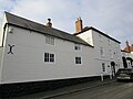
English: Wymeswold is a village (Calor Best Village in Leicestershire & Rutland 2008) and civil parish in the Charnwood district of Leicestershire, England. It is in the north of Leicestershire, and north-east of Loughborough. It has a population of about 1,000.
localité britannique du comté anglais de Leicestershire | |||||
| Téléverser des médias | |||||
| Nature de l’élément | |||||
|---|---|---|---|---|---|
| Lieu | Charnwood, Leicestershire, Midlands de l'Est, Angleterre | ||||
| Population |
| ||||
 | |||||
Sous-catégories
Cette catégorie comprend 5 sous-catégories, dont les 5 ci-dessous.
Média dans la catégorie « Wymeswold »
Cette catégorie comprend 313 fichiers, dont les 200 ci-dessous.
(page précédente) (page suivante)-
 11 Church Street, Wymeswold (geograph 7393081).jpg 1 024 × 768 ; 145 kio
-
 12, Far Street - geograph.org.uk - 2733608.jpg 1 280 × 959 ; 464 kio
-
 16 Far Street - geograph.org.uk - 2733630.jpg 1 280 × 975 ; 322 kio
-
 17 Church Street - geograph.org.uk - 2733974.jpg 1 280 × 959 ; 300 kio
-
 22 Clay Street - geograph.org.uk - 2733023.jpg 1 280 × 959 ; 330 kio
-
 23 and 23a Church Street - geograph.org.uk - 3208120.jpg 640 × 530 ; 112 kio
-
 24 Church Street, Wymeswold (geograph 7393065).jpg 1 024 × 768 ; 167 kio
-
 26 and 16A Church Street - geograph.org.uk - 2733968.jpg 1 280 × 959 ; 365 kio
-
 3 Church Street, Wymeswold (geograph 7393771).jpg 1 024 × 768 ; 135 kio
-
 49 Far Street - geograph.org.uk - 2733665.jpg 1 280 × 959 ; 285 kio
-
 5-11 Church Street - geograph.org.uk - 2733977.jpg 1 280 × 952 ; 260 kio
-
 55 London Lane, Wymeswold - geograph.org.uk - 5290341.jpg 1 280 × 829 ; 275 kio
-
 57 London Lane, Wymeswold - geograph.org.uk - 5290342.jpg 1 280 × 872 ; 268 kio
-
 58 Brook Street, Wymeswold (geograph 7393400).jpg 1 024 × 768 ; 144 kio
-
 A46 bridge over the A6006 - geograph.org.uk - 3078831.jpg 640 × 480 ; 81 kio
-
 A46 enters Leicestershire - geograph.org.uk - 4580971.jpg 2 079 × 1 429 ; 1,5 Mio
-
 A46 towards junction with A6006 - geograph.org.uk - 4581104.jpg 1 600 × 1 061 ; 281 kio
-
 A46-Foss Way from the south - geograph.org.uk - 5180844.jpg 640 × 475 ; 72 kio
-
 A46-Foss Way to the north - geograph.org.uk - 5180845.jpg 640 × 483 ; 71 kio
-
 A6006 at Leicestershire county boundary - geograph.org.uk - 3604224.jpg 640 × 481 ; 66 kio
-
 A6006 at Wymeswold village boundary - geograph.org.uk - 3604229.jpg 640 × 480 ; 51 kio
-
 A6006 East Road near Wymeswold - geograph.org.uk - 903866.jpg 640 × 421 ; 82 kio
-
 A6006 East Road nears bend - geograph.org.uk - 3604247.jpg 640 × 481 ; 55 kio
-

-
 A6006 near Dungehill Farm - geograph.org.uk - 3604261.jpg 640 × 480 ; 65 kio
-
 A6006 passes under the A46 - geograph.org.uk - 3604278.jpg 640 × 481 ; 63 kio
-
 A6006 towards Rempstone - geograph.org.uk - 3079358.jpg 640 × 480 ; 107 kio
-
 A6006 towards Rempstone - geograph.org.uk - 3079374.jpg 640 × 480 ; 76 kio
-
 A6006 towards Rempstone - geograph.org.uk - 3079410.jpg 640 × 480 ; 58 kio
-
 A6006 Wide Lane looking east - geograph.org.uk - 3604272.jpg 640 × 480 ; 57 kio
-
 A6006, Wymeswold - geograph.org.uk - 2086643.jpg 640 × 480 ; 46 kio
-
 A6006-Hades Lane junction - geograph.org.uk - 2086671.jpg 640 × 480 ; 95 kio
-
 Allotments on East Road - geograph.org.uk - 2733785.jpg 1 280 × 959 ; 395 kio
-
 Allotments, Wymeswold - geograph.org.uk - 4959376.jpg 1 024 × 768 ; 204 kio
-
 Animal trailer coming from Wymeswold - geograph.org.uk - 4942214.jpg 640 × 434 ; 50 kio
-
 Barn and house, Church Street - geograph.org.uk - 2733971.jpg 1 280 × 959 ; 357 kio
-
 Barn Farm, Wymeswold - geograph.org.uk - 15666.jpg 640 × 304 ; 68 kio
-
 Benchmark on wall of Wysall Lane - geograph.org.uk - 5235756.jpg 683 × 1 024 ; 318 kio
-
 Benchmark on wall on north side of Far Street - geograph.org.uk - 5235582.jpg 1 024 × 683 ; 338 kio
-
 Benchmark on ^3 Rempstone Road - geograph.org.uk - 5235534.jpg 614 × 1 024 ; 258 kio
-
 Bowling green, Wymeswold - geograph.org.uk - 4959373.jpg 1 024 × 768 ; 136 kio
-
 Brick wall on north side of the A6006 - geograph.org.uk - 5235632.jpg 1 024 × 683 ; 214 kio
-
 Bridleway off Narrow Lane - geograph.org.uk - 5818456.jpg 1 024 × 768 ; 261 kio
-
 Bridleway to Narrow Lane - geograph.org.uk - 5843411.jpg 1 024 × 768 ; 172 kio
-
 Bridleway to Narrow Lane - geograph.org.uk - 5843415.jpg 1 024 × 768 ; 319 kio
-
 Bridleway to Wymeswold - geograph.org.uk - 5843402.jpg 1 024 × 768 ; 163 kio
-
 Bridleway to Wymeswold - geograph.org.uk - 5843404.jpg 1 024 × 768 ; 181 kio
-
 Bridleway towards Wymeswold - geograph.org.uk - 2732775.jpg 1 280 × 959 ; 530 kio
-
 Broad Beans in Wymeswold - geograph.org.uk - 15667.jpg 640 × 574 ; 187 kio
-
 Brook Street - geograph.org.uk - 2733778.jpg 1 280 × 959 ; 373 kio
-
 Brook Street - geograph.org.uk - 2733782.jpg 1 280 × 959 ; 482 kio
-
 Brook Street passes the end of Church Street - geograph.org.uk - 3208121.jpg 640 × 492 ; 82 kio
-
 Brook Street passes the end of The Stockwell - geograph.org.uk - 3208122.jpg 640 × 497 ; 85 kio
-
 Brook Street ^ Wymeswold postbox (ref. LE12 161) - geograph.org.uk - 2733980.jpg 1 280 × 977 ; 413 kio
-
 Brook Street, looking east (2) - geograph.org.uk - 2733770.jpg 1 280 × 959 ; 431 kio
-
 Brook Street, looking east - geograph.org.uk - 2733769.jpg 1 280 × 959 ; 518 kio
-
 Bumps in the field - geograph.org.uk - 2733780.jpg 1 280 × 959 ; 249 kio
-
 Burton Lane - geograph.org.uk - 2732994.jpg 1 280 × 959 ; 497 kio
-
 Burton Lane - geograph.org.uk - 3823715.jpg 640 × 480 ; 33 kio
-
 Burton Lane - geograph.org.uk - 3823717.jpg 640 × 480 ; 47 kio
-
 Burton Lane towards Burton on the Wolds - geograph.org.uk - 3208117.jpg 640 × 495 ; 70 kio
-
 Burton Lane-Hoton Road junction - geograph.org.uk - 3208116.jpg 640 × 479 ; 68 kio
-
 Cattle holding pen, near Wymeswold - geograph.org.uk - 3870772.jpg 1 280 × 960 ; 481 kio
-
 Cemetery near Wymeswold - geograph.org.uk - 906199.jpg 640 × 448 ; 67 kio
-
 Chaucer House and Rectory Place - geograph.org.uk - 3208135.jpg 640 × 435 ; 86 kio
-
 Chaucer House sign - geograph.org.uk - 3208123.jpg 640 × 457 ; 50 kio
-
 Church Street - geograph.org.uk - 1502890.jpg 640 × 427 ; 77 kio
-
 Church Street - geograph.org.uk - 2733768.jpg 1 280 × 949 ; 411 kio
-
 Church Street - geograph.org.uk - 3208124.jpg 640 × 494 ; 68 kio
-
 Clay Street - geograph.org.uk - 2733022.jpg 1 280 × 959 ; 298 kio
-
-
 Cottage in Wymeswold - geograph.org.uk - 3079403.jpg 640 × 480 ; 61 kio
-
 Cottage on Rempstone Road - geograph.org.uk - 3079408.jpg 640 × 480 ; 61 kio
-
 Cottages off Far Street - geograph.org.uk - 916830.jpg 480 × 640 ; 64 kio
-
 Cottages on Brook Street (Nos. 64-66) - geograph.org.uk - 2733764.jpg 1 280 × 959 ; 249 kio
-
 Cottages, Clay Street, Wymeswold - geograph.org.uk - 4959365.jpg 1 024 × 768 ; 124 kio
-
 Cradock Cottage, Brook Street - geograph.org.uk - 2733772.jpg 1 280 × 959 ; 281 kio
-
 Crop field east of Wymeswold - geograph.org.uk - 3079395.jpg 640 × 480 ; 64 kio
-
 Cut hay field and derelict field barn - geograph.org.uk - 5843409.jpg 1 024 × 768 ; 147 kio
-
 Dalby interchange, A46 - geograph.org.uk - 2393388.jpg 640 × 435 ; 45 kio
-
 Dalby interchange, A46 - geograph.org.uk - 2393404.jpg 640 × 410 ; 47 kio
-
 Dalby interchange, A46 - geograph.org.uk - 2393418.jpg 640 × 430 ; 59 kio
-
 Derelict cottages, Clay Street - geograph.org.uk - 4960432.jpg 1 024 × 768 ; 159 kio
-
 Door at Lindum House - geograph.org.uk - 2733625.jpg 913 × 1 280 ; 293 kio
-
 Double stile - geograph.org.uk - 3829013.jpg 960 × 1 280 ; 396 kio
-
 Driveway to Sporting Lakeside - geograph.org.uk - 4942258.jpg 640 × 370 ; 51 kio
-
 Dungehill Farm - geograph.org.uk - 3079371.jpg 640 × 416 ; 46 kio
-
 Dying oak with nests - geograph.org.uk - 2732992.jpg 1 280 × 950 ; 353 kio
-
 East Road (A6006) towards Rempstone - geograph.org.uk - 3079397.jpg 640 × 480 ; 71 kio
-
 East Road - geograph.org.uk - 1298928.jpg 640 × 426 ; 67 kio
-
 East Road - geograph.org.uk - 2795807.jpg 3 648 × 2 736 ; 2,88 Mio
-
 East Road - geograph.org.uk - 3307160.jpg 640 × 427 ; 81 kio
-

-
 East Road from Wymeswold - geograph.org.uk - 4942215.jpg 640 × 491 ; 89 kio
-
 East Road near Wymeswold - geograph.org.uk - 903862.jpg 640 × 480 ; 88 kio
-
 East Road towards Wymeswold - geograph.org.uk - 903860.jpg 640 × 409 ; 80 kio
-
 East Road westwards towards Wymeswold - geograph.org.uk - 6197207.jpg 640 × 401 ; 52 kio
-
 East Road westwards towards Wymeswold - geograph.org.uk - 6197214.jpg 640 × 450 ; 57 kio
-
 East Road, Wymeswold - geograph.org.uk - 3870786.jpg 1 280 × 962 ; 175 kio
-
 East Road-Wide Lane-Back Lane junction - geograph.org.uk - 4942216.jpg 640 × 454 ; 71 kio
-
 End of Field Farm driveway on East Road - geograph.org.uk - 6197208.jpg 640 × 406 ; 63 kio
-
 Entrance to Oakridge - geograph.org.uk - 3079357.jpg 640 × 480 ; 104 kio
-

-
 Entrance to Wymeswold - geograph.org.uk - 3624623.jpg 640 × 480 ; 72 kio
-
 Entrance to Wymeswold Meadows Nature Reserve - geograph.org.uk - 4942217.jpg 640 × 485 ; 129 kio
-
 Entry to Wymeswold - geograph.org.uk - 2733016.jpg 1 280 × 959 ; 406 kio
-
 Fairham Brook near Willoughby - geograph.org.uk - 3826841.jpg 1 280 × 960 ; 381 kio
-
 Falcon House (3, Church Street) - geograph.org.uk - 2733978.jpg 1 280 × 966 ; 239 kio
-
 Falcon House sign - geograph.org.uk - 3208126.jpg 640 × 358 ; 41 kio
-
 Far Street (eastern end) - geograph.org.uk - 2733644.jpg 1 280 × 959 ; 253 kio
-
 Far Street - geograph.org.uk - 2733634.jpg 1 280 × 959 ; 309 kio
-
 Far Street - geograph.org.uk - 3208127.jpg 640 × 495 ; 77 kio
-
 Far Street towards Melton Mowbray - geograph.org.uk - 3208128.jpg 640 × 493 ; 89 kio
-

-
 Farm building east of Wysall Lane - geograph.org.uk - 6333085.jpg 640 × 435 ; 72 kio
-
 Farm building off Wymeswold Lane - geograph.org.uk - 3038616.jpg 640 × 480 ; 68 kio
-
 Farm near Willoughby-on-the-Wolds - geograph.org.uk - 3870788.jpg 1 280 × 824 ; 136 kio
-
 Farm shed and muck truck - geograph.org.uk - 3870775.jpg 1 280 × 950 ; 413 kio
-
 Farmland near the A46 - geograph.org.uk - 3079352.jpg 640 × 480 ; 63 kio
-
 Farmland near Wymeswold - geograph.org.uk - 146378.jpg 640 × 427 ; 106 kio
-
 Farmland near Wymeswold - geograph.org.uk - 3079389.jpg 640 × 480 ; 62 kio
-
 Farmland, Ella's Farm - geograph.org.uk - 3079361.jpg 640 × 480 ; 80 kio
-
 Field by the layby - geograph.org.uk - 3656490.jpg 2 014 × 1 510 ; 850 kio
-
 Field edge along East Road - geograph.org.uk - 6197209.jpg 640 × 470 ; 88 kio
-
 Field edge south of Hades Lane - geograph.org.uk - 6197216.jpg 640 × 439 ; 53 kio
-
 Field entrance off Narrow Lane - geograph.org.uk - 4942225.jpg 640 × 480 ; 116 kio
-
 Field Farm name sign - geograph.org.uk - 6197210.jpg 640 × 341 ; 66 kio
-
 Field footpath near Wymeswold - geograph.org.uk - 3870777.jpg 960 × 1 280 ; 408 kio
-
 Field north of Hades Lane - geograph.org.uk - 6197217.jpg 640 × 459 ; 51 kio
-
 Field south of Narrow Lane - geograph.org.uk - 4942218.jpg 640 × 406 ; 76 kio
-
 Fields near Wymeswold - geograph.org.uk - 2733989.jpg 1 280 × 959 ; 507 kio
-
 Fields west of Hades Lane - geograph.org.uk - 4942279.jpg 640 × 422 ; 74 kio
-
 Flush bracket bench mark, Brook Street, Wymeswold - geograph.org.uk - 5290339.jpg 1 280 × 944 ; 364 kio
-
 Flush bracket bench mark, Rempstone Road, Wymeswold - geograph.org.uk - 5290343.jpg 1 280 × 1 280 ; 511 kio
-
 Footpath across the fields - geograph.org.uk - 4942219.jpg 640 × 499 ; 83 kio
-
 Footpath between London Lane and Clay Street - geograph.org.uk - 4960436.jpg 1 024 × 768 ; 202 kio
-
 Footpath junction - geograph.org.uk - 2732996.jpg 1 280 × 959 ; 481 kio
-
 Footpath Near Wymeswold - geograph.org.uk - 2450184.jpg 1 496 × 1 122 ; 631 kio
-

-
 Footpath sign on Wysall Lane - geograph.org.uk - 6333087.jpg 640 × 522 ; 71 kio
-
 Footpath through field to Willoughby on the Wolds - geograph.org.uk - 3344264.jpg 2 110 × 1 292 ; 1,91 Mio
-
 Footpath to East Road - geograph.org.uk - 2733783.jpg 1 280 × 959 ; 457 kio
-
 Footpath to Thorpe in the Glebe - geograph.org.uk - 3826843.jpg 1 280 × 960 ; 435 kio
-
 Footpath towards Costock - geograph.org.uk - 6333088.jpg 640 × 456 ; 76 kio
-
 Footpath towards Willoughby on the Wolds - geograph.org.uk - 6333089.jpg 640 × 396 ; 50 kio
-
 Footpath towards Wymondham - geograph.org.uk - 6333090.jpg 640 × 456 ; 73 kio
-
 Former School, Far Street - geograph.org.uk - 2733955.jpg 1 280 × 959 ; 352 kio
-
 Freshly harvested forage - geograph.org.uk - 6197218.jpg 640 × 461 ; 64 kio
-
 G,G,Granvilles - geograph.org.uk - 2733641.jpg 1 280 × 949 ; 343 kio
-
 Gate and footpath - geograph.org.uk - 4942220.jpg 640 × 426 ; 98 kio
-
 Gateway north of Hades Lane - geograph.org.uk - 6197219.jpg 640 × 455 ; 84 kio
-
 Gateway on a bridleway near Wymeswold - geograph.org.uk - 5843398.jpg 1 024 × 768 ; 189 kio
-
 Gateway to a field near to Dungehill Farm - geograph.org.uk - 4942231.jpg 640 × 474 ; 79 kio
-
 Hades Lane - geograph.org.uk - 4942272.jpg 640 × 410 ; 61 kio
-
 Hades Lane bends to avoid the Fosseway - geograph.org.uk - 4942280.jpg 640 × 474 ; 77 kio
-
 Hades Lane southwards - geograph.org.uk - 6197220.jpg 640 × 438 ; 44 kio
-

-
 Hades Lane towards Willoughby on the Wolds - geograph.org.uk - 3079355.jpg 640 × 480 ; 63 kio
-
 Hades Lane towards Willoughby-on-the-Wolds - geograph.org.uk - 4942281.jpg 640 × 462 ; 49 kio
-
 Hades Lane towards Willoughby-on-the-Wolds - geograph.org.uk - 6197221.jpg 640 × 451 ; 81 kio
-
 Hades Lane-Paddy's Lane junction - geograph.org.uk - 4942273.jpg 640 × 415 ; 97 kio
-
 HermitageinWymeswoldPottersSchool.gif 502 × 361 ; 12 kio
-
 Home Leys Way, Wymeswold - geograph.org.uk - 2450182.jpg 1 496 × 1 122 ; 490 kio
-
 Hot air balloon - geograph.org.uk - 2859449.jpg 882 × 1 024 ; 92 kio
-
 Hoton Road - geograph.org.uk - 2733019.jpg 1 280 × 959 ; 311 kio
-
 Hoton Road at Burton Lane - geograph.org.uk - 2733018.jpg 1 280 × 959 ; 353 kio
-
 House on Rempstone Road - geograph.org.uk - 5235555.jpg 1 024 × 683 ; 155 kio
-
 Houses for sale on Church Street Wymeswold - geograph.org.uk - 3208130.jpg 640 × 450 ; 74 kio
-
 Houses in Wymeswold - geograph.org.uk - 6426216.jpg 768 × 1 024 ; 171 kio
-
 Houses on Brook Street - geograph.org.uk - 2733773.jpg 1 280 × 959 ; 423 kio
-
 Houses, Church Street, Wymeswold (geograph 7393079).jpg 1 024 × 768 ; 130 kio
-
 It's a busy day on the Fosseway - geograph.org.uk - 4942275.jpg 640 × 451 ; 82 kio
-
 Junction of Rectory Place and The Stockwell - geograph.org.uk - 3208131.jpg 640 × 484 ; 79 kio
-
 Kings Farm - geograph.org.uk - 4942226.jpg 640 × 398 ; 44 kio
-
 Lindum House, Far Street - geograph.org.uk - 2733622.jpg 1 280 × 947 ; 246 kio
-
 Little Thatch, Brook Street - geograph.org.uk - 2733767.jpg 1 280 × 959 ; 319 kio
-
 Little Thatch, Wymeswold (geograph 7393641).jpg 1 024 × 768 ; 179 kio
-
 Marshmallow Cottage - geograph.org.uk - 2733639.jpg 1 280 × 941 ; 283 kio
-
 Modern housing, old style, at Manor Court - geograph.org.uk - 2733784.jpg 1 280 × 949 ; 290 kio
-
 Muddy field near Willoughby on the Wolds - geograph.org.uk - 4959383.jpg 1 024 × 768 ; 201 kio
-
 Narrow Lane towards Six Hills - geograph.org.uk - 4942212.jpg 640 × 441 ; 49 kio
-
 Narrow Lane towards Six Hills - geograph.org.uk - 4942227.jpg 640 × 526 ; 92 kio
-
 Narrow Lane towards Six Hills - geograph.org.uk - 4942254.jpg 640 × 446 ; 74 kio
-
 Narrow Lane towards Wymeswold - geograph.org.uk - 4942213.jpg 640 × 434 ; 48 kio
-
 Narrow Lane towards Wymeswold - geograph.org.uk - 4942221.jpg 640 × 427 ; 60 kio
-
 Narrow Lane towards Wymeswold - geograph.org.uk - 4942228.jpg 640 × 465 ; 68 kio
-
 Narrow Lane towards Wymeswold - geograph.org.uk - 4942255.jpg 640 × 424 ; 71 kio
-
 New Holland FX30 Forage Harvester - geograph.org.uk - 6197222.jpg 640 × 491 ; 81 kio
-
 New houses, Mantle Croft - geograph.org.uk - 2733982.jpg 1 280 × 856 ; 293 kio
-

-
 Number 2 The Stockwell - geograph.org.uk - 3208132.jpg 640 × 451 ; 81 kio
-
 Oil seed rape almost in flower - geograph.org.uk - 4942229.jpg 640 × 463 ; 101 kio
-
 Out for a ride on Narrow Lane - geograph.org.uk - 5097524.jpg 640 × 457 ; 107 kio
-
 Overgrown field entrance - geograph.org.uk - 6197215.jpg 640 × 487 ; 87 kio
-
 Path and housing, Trinity Crescent - geograph.org.uk - 4959378.jpg 1 024 × 768 ; 156 kio
-
 Picture postcard village (2) - geograph.org.uk - 2733759.jpg 1 280 × 893 ; 510 kio
-
 Picture postcard village - geograph.org.uk - 2733756.jpg 1 280 × 904 ; 494 kio
-
 Post box LE12 113 - geograph.org.uk - 3208133.jpg 586 × 640 ; 101 kio
-
 Post Box Number LE12 112 - geograph.org.uk - 3208134.jpg 640 × 482 ; 84 kio
-
 Power lines crossing East Road - geograph.org.uk - 2795815.jpg 3 551 × 2 638 ; 2,09 Mio
.jpg)


.jpg)

.jpg)


.jpg)


_-_geograph.org.uk_-_2733980.jpg)
_-_geograph.org.uk_-_2733770.jpg)


_-_geograph.org.uk_-_2733632.jpg)


_-_geograph.org.uk_-_2733764.jpg)


_towards_Rempstone_-_geograph.org.uk_-_3079397.jpg)


_-_geograph.org.uk_-_2733978.jpg)

_-_geograph.org.uk_-_2733644.jpg)


.jpg)


.jpg)


_-_geograph.org.uk_-_2733759.jpg)


