Category:Ysceifiog
Vai alla navigazione
Vai alla ricerca
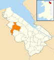
village and community in Flintshire, Wales, UK   | |||||
| Carica un file multimediale | |||||
| Istanza di | |||||
|---|---|---|---|---|---|
| Luogo | Flintshire, Galles | ||||
| Popolazione |
| ||||
| Superficie |
| ||||
 | |||||
Cymraeg: Pentref bychan a phlwyf yn Sir y Fflint yw Ysgeifiog (hefyd Ysceifiog). Saif ar ffordd gefn ychydig i'r gogledd o'r briffordd A541 rhwng Nannerch a Caerwys.
English: Ysceifiog is a small village situated approximately seven miles north-west of Mold, Flintshire.
Sottocategorie
Questa categoria contiene un'unica sottocategoria, indicata di seguito.
S
- St Mary's Church, Ysceifiog (4 F)
File nella categoria "Ysceifiog"
Questa categoria contiene 162 file, indicati di seguito, su un totale di 162.
-
 2010 Wales Flintshire Community Ysceifiog map.svg 512 × 568; 494 KB
-
 2024 Wales Flintshire Community Ysceifiog map.svg 512 × 568; 394 KB
-
 A section of the minor road between Trefechan and Cimwch - geograph.org.uk - 5980921.jpg 4 000 × 3 000; 5,04 MB
-
 A541 looking east - geograph.org.uk - 2763967.jpg 640 × 480; 66 KB
-
 A541 looking east - geograph.org.uk - 2763979.jpg 640 × 453; 49 KB
-
 A541 near Sarn Farm - geograph.org.uk - 2763978.jpg 640 × 453; 53 KB
-
 An enclosed track heading away from Cimwch - geograph.org.uk - 5980941.jpg 4 000 × 3 000; 4,96 MB
-
 Ascending Penycloddiau - geograph.org.uk - 1329721.jpg 640 × 480; 67 KB
-
 Babell Chapel - geograph.org.uk - 1571724.jpg 640 × 480; 95 KB
-
 Babell village and Black Lion Inn - geograph.org.uk - 4251562.jpg 640 × 480; 36 KB
-
 Barn at Plas Coch - geograph.org.uk - 4393316.jpg 4 608 × 2 592; 4,25 MB
-
 Body in the bath - geograph.org.uk - 1572096.jpg 640 × 480; 124 KB
-
 Bracket fungi - geograph.org.uk - 241796.jpg 480 × 640; 103 KB
-
 Bridleway from Ysceifiog - geograph.org.uk - 3735001.jpg 3 264 × 2 448; 4,56 MB
-
 Bronze Age burial cairn, Penycloddiau - geograph.org.uk - 6154168.jpg 1 024 × 683; 133 KB
-

-
 Bryngaer Pen y Cloddiau Hillfort - geograph.org.uk - 3956375.jpg 640 × 480; 97 KB
-
 Burial Mound, Penycloddiau - geograph.org.uk - 3685956.jpg 1 920 × 2 560; 1,32 MB
-

-
 Cairn on top of Penycloddiau - geograph.org.uk - 5456248.jpg 1 600 × 1 123; 560 KB
-
 Can you see where you're going^ - geograph.org.uk - 1571735.jpg 640 × 480; 76 KB
-
 Coed D'Arcis - geograph.org.uk - 4674688.jpg 5 184 × 2 596; 1,68 MB
-
 Coed-mynydd-isaf Farm - geograph.org.uk - 2095431.jpg 3 547 × 2 350; 6,25 MB
-
 Converted barn near Caerwys - geograph.org.uk - 1572100.jpg 640 × 480; 87 KB
-
 Country road at Mynydd Llan - geograph.org.uk - 1572072.jpg 640 × 480; 93 KB
-
 Crossroads near Groesfford Farm - geograph.org.uk - 4251525.jpg 640 × 480; 30 KB
-
 Crown Inn, Lixwm - geograph.org.uk - 6147891.jpg 4 000 × 3 000; 2,58 MB
-
 Ddol - geograph.org.uk - 4674693.jpg 5 184 × 2 258; 1,53 MB
-
 Dirt Road near the Offa's Dyke Path - geograph.org.uk - 6393618.jpg 3 648 × 2 736; 3,21 MB
-
 Enclosed path - geograph.org.uk - 3735022.jpg 3 264 × 2 448; 5,19 MB
-
 Farm lanes - geograph.org.uk - 132308.jpg 640 × 480; 73 KB
-
 Farm rubbish near Babell - geograph.org.uk - 1571683.jpg 640 × 474; 124 KB
-
 Farmland east of Caerwys - geograph.org.uk - 1251476.jpg 640 × 480; 47 KB
-
 Farmland north of Lixwm - geograph.org.uk - 6147886.jpg 4 000 × 3 000; 2,63 MB
-
 Farmyard at Waen Isa - geograph.org.uk - 1571747.jpg 640 × 480; 69 KB
-
 Ffordd Berthen - geograph.org.uk - 2232541.jpg 4 000 × 3 000; 5,99 MB
-
 Ffordd Calcoed - geograph.org.uk - 2238547.jpg 4 000 × 3 000; 5,04 MB
-
 Ffordd Y Graig - geograph.org.uk - 2232134.jpg 4 000 × 3 000; 4,79 MB
-
 Field edge path and stile near Bryn Glas - geograph.org.uk - 5981236.jpg 4 000 × 3 000; 4,8 MB
-

-

-
 Footpath crossing a field with grazing sheep at Babell - geograph.org.uk - 5981239.jpg 4 000 × 3 000; 4,23 MB
-
 Footpath heading towards Coed-y-Llan wood - geograph.org.uk - 3735051.jpg 3 264 × 2 448; 3,74 MB
-
 Former Tollhouse by the A541, Ddol - geograph.org.uk - 6114863.jpg 960 × 720; 103 KB
-
 Former Tollhouse by the A541, Nannerch - geograph.org.uk - 6114765.jpg 2 048 × 1 370; 488 KB
-
 Gate approach - geograph.org.uk - 2276624.jpg 4 000 × 3 000; 4,52 MB
-
 Gwter Goch - geograph.org.uk - 6058294.jpg 4 000 × 3 000; 2,88 MB
-
 Heather on Penycloddiau in September - geograph.org.uk - 2609907.jpg 640 × 480; 115 KB
-
 Hill fort rampart on Penycloddiau - geograph.org.uk - 1317771.jpg 640 × 480; 69 KB
-
 Iron Age Ramparts, Pencloddiau - geograph.org.uk - 4292841.jpg 1 741 × 1 161; 615 KB
-
 Lane at Waen-isaf - geograph.org.uk - 4251563.jpg 640 × 481; 57 KB
-
 Lane junction at Groes Faen Bach - geograph.org.uk - 4251565.jpg 640 × 480; 79 KB
-
 Lane near Hafod-dew - geograph.org.uk - 4251527.jpg 640 × 481; 42 KB
-
 Lane near Llwyn-y-cosyn Farm - geograph.org.uk - 4251522.jpg 640 × 481; 57 KB
-
 Lean To - geograph.org.uk - 2232117.jpg 4 000 × 3 000; 5,01 MB
-
 Lixwm turn - geograph.org.uk - 2232543.jpg 4 000 × 3 000; 5,05 MB
-
 Llwybr Ceffyl - geograph.org.uk - 2275644.jpg 4 000 × 3 000; 5,08 MB
-
 Llwybr Clawdd Offa - Offa's Dyke Path - geograph.org.uk - 3956567.jpg 3 264 × 2 448; 3,64 MB
-
 Llwyn Errdyn - geograph.org.uk - 4393358.jpg 4 608 × 2 592; 4,35 MB
-
 Melin y Wern - geograph.org.uk - 4674628.jpg 3 442 × 4 000; 1,57 MB
-
 Minor road near Moel y Parc Transmitting Station - geograph.org.uk - 5981026.jpg 4 000 × 3 000; 5,12 MB
-

-
 Modern Steps from Penycloddiau - geograph.org.uk - 2849607.jpg 3 456 × 5 184; 5,04 MB
-
 Moel-y-parc - geograph.org.uk - 4674814.jpg 4 928 × 2 903; 1,81 MB
-
 Moel-y-Parc Television Transmitter - geograph.org.uk - 4675518.jpg 3 379 × 5 184; 1,38 MB
-
 Moel-y-Parc Television Transmitter - geograph.org.uk - 4675519.jpg 3 226 × 5 184; 1,93 MB
-
 Moel-y-Parc transmitter, aerial 2015 - geograph.org.uk - 4693000.jpg 533 × 800; 68 KB
-
 Moel-y-Parc Trig Point - geograph.org.uk - 2238471.jpg 2 592 × 1 728; 1,06 MB
-
 Nant Coed-y-mynydd - geograph.org.uk - 4674809.jpg 4 468 × 3 385; 1,79 MB
-
 Nant Coed-y-mynydd - geograph.org.uk - 4674812.jpg 5 107 × 2 985; 1,64 MB
-
 Nosy pony at Truly Farm - geograph.org.uk - 1571689.jpg 640 × 480; 98 KB
-
 Offa's Dyke Footpath near Penycloddiau - geograph.org.uk - 2849585.jpg 5 184 × 3 456; 3,81 MB
-
 Offa's Dyke Footpath on Penycloddiau - geograph.org.uk - 2849476.jpg 5 184 × 3 456; 4,35 MB
-
 Offa's Dyke Footpath on Penycloddiau - geograph.org.uk - 2849511.jpg 5 184 × 3 456; 3,41 MB
-
 Offa's Dyke Path - geograph.org.uk - 3684280.jpg 2 560 × 1 920; 786 KB
-
 Offa's Dyke Path - geograph.org.uk - 6052817.jpg 4 000 × 3 000; 2,64 MB
-
 Offa's Dyke path crossing Penycloddiau hill fort - geograph.org.uk - 3776222.jpg 3 900 × 4 160; 2,48 MB
-
 Offa's Dyke path leaving Penycloddiau - geograph.org.uk - 3776181.jpg 3 840 × 2 700; 1,59 MB
-
 Offa's Dyke Path near Nant Coed-y-mynydd - geograph.org.uk - 2853916.jpg 5 184 × 3 456; 4,97 MB
-
 Offa's Dyke Path near Nant y Mynydd - geograph.org.uk - 6393652.jpg 3 648 × 2 736; 2,99 MB
-
 Offa's Dyke Path near Penycloddiau - geograph.org.uk - 616206.jpg 640 × 480; 107 KB
-

-
 Offa's Dyke Path on Penycloddiau - geograph.org.uk - 2849393.jpg 3 456 × 5 184; 4,5 MB
-
 Offa's Dyke Path on Penycloddiau - geograph.org.uk - 6052834.jpg 4 000 × 3 000; 2,9 MB
-

-
 Offa's Dyke Path to the summit of Pen-y-Cloddiau - geograph.org.uk - 6359549.jpg 2 498 × 1 375; 765 KB
-
 Offa's Dyke path, Penycloddiau - geograph.org.uk - 6154151.jpg 1 024 × 683; 161 KB
-
 Offa's Dyke path, Penycloddiau - geograph.org.uk - 6154157.jpg 1 024 × 683; 177 KB
-
 Offa's Dyke path, Penycloddiau - geograph.org.uk - 6154164.jpg 1 024 × 683; 160 KB
-
 On the summit of Penycloddiau - geograph.org.uk - 6052830.jpg 4 000 × 3 000; 2,89 MB
-
 Outer Defence Wall on Penycloddiau Hill Fort - geograph.org.uk - 2849449.jpg 5 184 × 3 456; 4,86 MB
-
 Pant-y-ffuon - geograph.org.uk - 4674633.jpg 5 184 × 2 770; 1,7 MB
-
 Pen-y-Cloddiau - geograph.org.uk - 6361374.jpg 3 777 × 2 833; 1,99 MB
-
 Penycloddiau - geograph.org.uk - 3956370.jpg 3 264 × 2 448; 3,87 MB
-
 Penycloddiau - geograph.org.uk - 3956396.jpg 3 264 × 2 448; 3,64 MB
-
 Penycloddiau - geograph.org.uk - 3956549.jpg 3 264 × 2 448; 3,59 MB
-
 Penycloddiau - geograph.org.uk - 4675478.jpg 5 082 × 2 637; 1,93 MB
-
 Penycloddiau - geograph.org.uk - 6052819.jpg 4 000 × 3 000; 2,9 MB
-
 Penycloddiau - Hill Fort with Moel Famau in the distance - geograph.org.uk - 2739005.jpg 1 971 × 1 077; 933 KB
-
 Penycloddiau Bronze Age Burial Mound - geograph.org.uk - 2849557.jpg 5 184 × 3 456; 4,54 MB
-
 Penycloddiau burial mound reconstruction - geograph.org.uk - 6237249.jpg 1 024 × 768; 719 KB
-
 Penycloddiau Summit - geograph.org.uk - 3685952.jpg 2 560 × 1 920; 2,09 MB
-
 Penycloddiau Summit cairn - geograph.org.uk - 3366179.jpg 2 592 × 1 944; 1,47 MB
-
 Plas Coch (Red Mansion) - geograph.org.uk - 4392238.jpg 4 608 × 2 592; 4,75 MB
-
 Pond on Penycloddiau - geograph.org.uk - 2849462.jpg 5 184 × 3 456; 4,76 MB
-
 Racecourse Farm, Gorsedd - geograph.org.uk - 6058296.jpg 4 000 × 3 000; 2,34 MB
-
 Recently ploughed field - geograph.org.uk - 6147889.jpg 4 000 × 3 000; 2,27 MB
-
 Reconstructed burial mound on the summit of Pen-y-Cloddiau - geograph.org.uk - 6359552.jpg 3 777 × 2 833; 2,02 MB
-
 Road to Afonwen - geograph.org.uk - 2095397.jpg 3 664 × 2 349; 6,45 MB
-
 Roadside tip - geograph.org.uk - 1251485.jpg 640 × 480; 118 KB
-
 Sarn Farm - geograph.org.uk - 4674690.jpg 4 058 × 2 719; 1,79 MB
-
 Self catering Cottage - geograph.org.uk - 2095419.jpg 3 948 × 2 302; 6,99 MB
-
 Seven Springs Fishery, Caerwys - geograph.org.uk - 1251450.jpg 640 × 480; 124 KB
-
 Sheep in the early morning - geograph.org.uk - 1855353.jpg 2 048 × 1 536; 653 KB
-
 Small Pool on Penycloddiau - geograph.org.uk - 3684297.jpg 2 560 × 1 920; 1,98 MB
-
 Spiny Puffball on Pen-y-Cloddiau - geograph.org.uk - 6359553.jpg 2 565 × 1 903; 2,12 MB
-
 Step a long - geograph.org.uk - 2275651.jpg 3 000 × 4 000; 5,9 MB
-
 Stepped path - geograph.org.uk - 2276626.jpg 3 000 × 4 000; 4,4 MB
-
 Stile and signpost, Penycloddiau - geograph.org.uk - 6052811.jpg 4 000 × 3 000; 2,53 MB
-

-
 Stone stile - geograph.org.uk - 3734917.jpg 3 264 × 2 448; 5,95 MB
-
 Telecoms mast at Moel y Parc, from Penycloddiau - geograph.org.uk - 6052842.jpg 4 000 × 3 000; 2,44 MB
-
 The Clwydian Range from Penycloddiau - geograph.org.uk - 6052839.jpg 4 000 × 3 000; 2,63 MB
-
 The Earthworks of Penycloddiau Hill Fort - geograph.org.uk - 2849403.jpg 5 184 × 3 456; 5,04 MB
-
 The eastern side of Penycloddiau - geograph.org.uk - 6052826.jpg 4 000 × 3 000; 2,24 MB
-
 The Fox Inn - geograph.org.uk - 132313.jpg 640 × 480; 81 KB
-
 The remains of the Holywell Racecourse Grandstand - geograph.org.uk - 4367763.jpg 4 608 × 2 592; 3,96 MB
-
 Track to Nant Coed-y-mynydd - geograph.org.uk - 1960240.jpg 640 × 451; 132 KB
-
 Track to Swallows Rest - geograph.org.uk - 2095409.jpg 3 352 × 2 350; 6,67 MB
-
 TV Transmission Mast - geograph.org.uk - 2093339.jpg 480 × 640; 64 KB
-
 TV Transmitter - geograph.org.uk - 2095386.jpg 2 525 × 3 722; 6,77 MB
-
 Two ways - geograph.org.uk - 2232545.jpg 4 000 × 3 000; 6,03 MB
-
 Unsurfaced road near Nant Coed-y-mynydd - geograph.org.uk - 6154177.jpg 1 024 × 683; 189 KB
-
 View from Penycloddiau - geograph.org.uk - 6052833.jpg 4 000 × 3 000; 2,53 MB
-
 View from Penycloddiau Hill Fort - geograph.org.uk - 2849422.jpg 5 184 × 3 456; 3,57 MB
-
 View from Penycloddiau Hill Fort - geograph.org.uk - 2849436.jpg 5 184 × 3 456; 3,6 MB
-
 View north from the summit of Pen-y-Cloddiau - geograph.org.uk - 6359550.jpg 4 000 × 3 000; 2,48 MB
-

-
 Water Tank below Bryn Golau - geograph.org.uk - 346664.jpg 640 × 480; 202 KB
-
 Water Tank below Bryn Golau - geograph.org.uk - 346673.jpg 640 × 480; 190 KB
-
 Water Tank below Bryn Golau - geograph.org.uk - 346692.jpg 640 × 480; 87 KB
-
 Way wood - geograph.org.uk - 2232546.jpg 3 000 × 4 000; 5,07 MB
-
 Wide lane - geograph.org.uk - 2232113.jpg 4 000 × 3 000; 6,03 MB
-
 Ysceifiog - geograph.org.uk - 132312.jpg 640 × 480; 105 KB
-
 Ysceifiog cottage - geograph.org.uk - 132315.jpg 640 × 480; 72 KB
-
 Ysceifiog farm building - geograph.org.uk - 132309.jpg 640 × 480; 70 KB
-
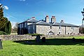 Ysceifiog Old Rectory.jpg 3 872 × 2 592; 2,81 MB
-
 Ysceifiog village hall - geograph.org.uk - 132317.jpg 487 × 509; 38 KB
-
 Ysceifiog Village Hall - geograph.org.uk - 1585064.jpg 640 × 480; 61 KB
-
 Ancient Track below Bryn Golau - geograph.org.uk - 347571.jpg 640 × 480; 287 KB
-
 Ancient Trackway - geograph.org.uk - 347300.jpg 640 × 480; 294 KB
-
 Ancient Trackway below Bryn Golau - geograph.org.uk - 337610.jpg 640 × 480; 233 KB
-
 Ancient Trackway below Bryn Golau - geograph.org.uk - 347502.jpg 640 × 480; 225 KB
-
 Bridleway near Penycloddiau - geograph.org.uk - 624469.jpg 640 × 480; 131 KB
-
 Bryn-y-Cosyn Farm - geograph.org.uk - 62484.jpg 640 × 480; 110 KB
-
 Clwydian Hills near Moel Arthur - geograph.org.uk - 624466.jpg 640 × 480; 68 KB
-
 Country Cottage - geograph.org.uk - 346652.jpg 640 × 480; 225 KB
-
 Footpath and Stile near Pen-y-felin - geograph.org.uk - 347553.jpg 480 × 640; 263 KB
-
 Public Footpath to Pen-y-mynydd - geograph.org.uk - 346632.jpg 640 × 480; 227 KB
-
 Stile below Bryn Golau - geograph.org.uk - 346602.jpg 480 × 640; 251 KB
-
 Stile below Bryn Golau - geograph.org.uk - 346614.jpg 640 × 480; 206 KB
-
 Track from Pen-y-mynydd - geograph.org.uk - 346639.jpg 640 × 480; 247 KB


_-_geograph.org.uk_-_4392238.jpg)


