Category:Yufu, Oita
Zur Navigation springen
Zur Suche springen

Ort in der Präfektur Ōita, Japan     | |||||
| Medium hochladen | |||||
| Ist ein(e) | |||||
|---|---|---|---|---|---|
| Ort | Präfektur Ōita, Japan | ||||
| Rechtsform |
| ||||
| Datum der Gründung, Erstellung, Entstehung, Erbauung |
| ||||
| Einwohnerzahl |
| ||||
| Fläche |
| ||||
| Ersetzt |
| ||||
| offizielle Website | |||||
 | |||||
Unterkategorien
Es werden 10 von insgesamt 10 Unterkategorien in dieser Kategorie angezeigt:
In Klammern die Anzahl der enthaltenen Kategorien (K), Seiten (S), Dateien (D)
G
H
- JGSDF Hijūdai Maneuver Area (16 D)
J
- JGSDF Camp Yufuin (8 D)
P
- Post offices in Yufu (2 D)
S
- Symbols of Yufu, Oita (7 D)
T
U
- Unaguhime-jinja (23 D)
Y
- Yufu City Community Bus (3 D)
Medien in der Kategorie „Yufu, Oita“
Folgende 74 Dateien sind in dieser Kategorie, von 74 insgesamt.
-
 Yufu in Oita Prefecture Ja.svg 560 × 622; 10 KB
-
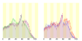 Population distribution of Yufu, Oita, Japan.svg 512 × 256; 22 KB
-
 Bussanji.JPG 1.280 × 960; 484 KB
-
 Confluence of Oitagawa River (right) and Shiratakigawa River (left).JPG 3.264 × 2.448; 2,71 MB
-
 E34OITA-EXP YufudakeSIC.jpg 2.048 × 1.152; 2,3 MB
-
 E34OITA-EXP YufuinIC.jpg 2.048 × 1.152; 2,44 MB
-
 Hasama Branch of Japan Agricultural Coorperatives Oita.jpg 3.891 × 2.919; 2,1 MB
-
 Kyushuhonzan-hondo.jpg 620 × 312; 35 KB
-
 Kyushuhonzan-jizodo.jpg 394 × 254; 30 KB
-
 Kyushuhonzan-main.JPG 2.853 × 1.809; 382 KB
-
 Kyushuhonzan-sanmon.jpg 698 × 280; 236 KB
-
 Map Yufu en.png 1.181 × 901; 35 KB
-
 Michinoeki yufuin.jpg 960 × 720; 141 KB
-
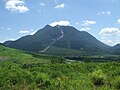
 Mt. Yufu and Yufudake PA.jpg 2.304 × 3.072; 4,9 MB
-
 Mt.Imorigajo 01.jpg 3.888 × 2.592; 1,9 MB
-
 Mt.Imorigajo 02.jpg 2.592 × 3.888; 2,92 MB
-
 Mt.Imorigajo 03.jpg 3.888 × 2.592; 2 MB
-
 Oita Expressway - Near Yufudake PA.jpg 1.280 × 960; 551 KB
-
 Oita Expressway in Nanazoshi, Hasama, Yufu, Oita.jpg 4.032 × 3.024; 1,97 MB
-
 Oita Expressway near border of Beppu City and Yufu City 2.jpg 4.032 × 3.024; 1,62 MB
-
 Oita Expressway near border of Beppu City and Yufu City.jpg 4.032 × 3.024; 1,74 MB
-
 Oita Expressway near border of Oita City and Yufu City.jpg 4.032 × 3.024; 2,08 MB
-
 Oita Prefectural Road No.540 near Onoya Station 2.jpg 3.956 × 2.967; 3,74 MB
-
 Oita Prefectural Road No.540 near Onoya Station.jpg 3.886 × 2.915; 3,85 MB
-
 Oita yufudake parking.jpg 1.280 × 960; 719 KB
-
 Oita-yufuin-interchange.jpg 1.280 × 960; 578 KB
-
 Oitagawa River and Onoya-Ohashi Bridge from Sekinan-Ohashi Bridge.jpg 3.986 × 2.989; 3,35 MB
-
 Oitagawa River from Sekinan-Ohashi Bridge (west) 2.jpg 4.032 × 3.024; 3,82 MB
-
 Oitagawa River from Sekinan-Ohashi Bridge (west).jpg 3.934 × 2.951; 3,84 MB
-
 Oitagawa River near Onoya Station 2.jpg 3.945 × 2.959; 3,23 MB
-
 Oitagawa River near Onoya Station.jpg 3.875 × 2.907; 2,92 MB
-
 Paddy field in winter near Yufuin Hot Spring and Mount Fukumazan.JPG 3.264 × 2.448; 1,82 MB
-
 Panorama view of Yufuin.jpg 2.592 × 1.662; 701 KB
-
 Shonaicho Takaoka, Yufu, Oita Prefecture 879-5433, Japan - panoramio.jpg 2.272 × 1.704; 821 KB
-
 Tsukahara-spa.jpg 2.048 × 1.536; 833 KB
-
 Tsukaharakogen.jpg 2.048 × 1.536; 810 KB
-
 View from overpass of Onoya Station.jpg 3.962 × 2.971; 2,92 MB
-
 View in front of Mukainoharu Station.jpg 4.007 × 3.005; 3,49 MB
-
 View in front of Onoya Station.jpg 3.979 × 2.984; 3,61 MB
-
 View near Shonai Station.jpg 3.879 × 2.910; 3,88 MB
-
 Yufu City Firefighters headquater.jpg 4.272 × 2.848; 3,55 MB
-
 Yufu city hall.JPG 4.608 × 1.315; 1,34 MB
-
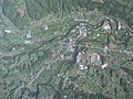
 Yufu city Hasama district Aerial photograph.2014.jpg 7.197 × 5.398; 13,59 MB
-
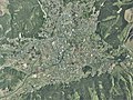
 Yufu city Shonai district Aerial photograph.2013.jpg 2.900 × 2.175; 2,22 MB
-
 Yufu city Yufuin district Aerial photograph.2014.jpg 6.995 × 5.246; 14,45 MB
-
 Yufu in Oita Prefecture.png 1.181 × 901; 36 KB
-
 Yufudake.jpg 1.024 × 768; 151 KB
-
 Yufudake08.JPG 3.296 × 2.472; 3,85 MB
-
 Yufugawa Valley.jpg 1.615 × 2.355; 667 KB
-
 Yufuin banner.JPG 2.100 × 301; 389 KB
-
 Yufuin Branch of the Howa Bank.JPG 3.264 × 2.448; 1,83 MB
-
 Yufuin Map - panoramio.jpg 2.272 × 1.704; 1,16 MB
-
 Yufuin panorama.jpg 2.048 × 1.536; 514 KB
-
 Yufuin, Ōita Prefecture (4 November 2006).jpg 1.600 × 1.110; 773 KB
-
 Yufuin-YH.jpg 2.048 × 1.536; 715 KB
-
 Yufuincho Kawakami, Yufu, Oita Prefecture 879-5102, Japan - panoramio - Nagono.jpg 2.272 × 1.704; 986 KB
-
 Yuhu town in August.jpg 2.323 × 445; 804 KB
-
 Yuhu-exp.jpg 3.008 × 2.000; 3,65 MB
-
 Yuhu-exp2.jpg 3.008 × 2.000; 3,56 MB
-
 Yuhuin-YH.jpg 1.536 × 2.048; 748 KB
-
 Yuhuinchou.jpg 480 × 640; 248 KB
-
 Yuhuinnomori.jpg 1.024 × 682; 637 KB
-
 よいやな清流.jpg 3.236 × 1.838; 1,19 MB
-
 よいやな湧水.jpg 8.688 × 5.792; 8,5 MB
-
 よいやな湧水場.jpg 3.539 × 2.648; 1,89 MB
-
 囲碁神社その1 - panoramio.jpg 4.896 × 3.264; 6,26 MB
-
 囲碁神社その2 - panoramio.jpg 4.896 × 3.264; 6,77 MB
-
 大分大学医学部附属病院.jpg 600 × 400; 313 KB
-
 大分県道207号 大分挾間線.jpg 4.032 × 3.024; 5,1 MB
-
 湯布院 - panoramio.jpg 640 × 427; 98 KB
-
 狭霧台の山側 - panoramio.jpg 1.600 × 1.200; 438 KB
-
 銭瓶峠.jpg 5.504 × 3.096; 8,12 MB
-
 銭瓶峠の道標.jpg 3.096 × 5.504; 10,25 MB
-
 銭瓶石.jpg 5.504 × 3.096; 10,3 MB


_and_Shiratakigawa_River_(left).JPG)


_2.jpg)
.jpg)


.jpg)


