File:Ōashi Station plan.jpg
跳至導覽
跳至搜尋
預覽大小:724 × 600 像素。 其他解析度:290 × 240 像素 | 580 × 480 像素 | 838 × 694 像素。
原始檔案 (838 × 694 像素,檔案大小:421 KB,MIME 類型:image/jpeg)
說明
說明
添加單行說明來描述出檔案所代表的內容
摘要
[編輯]| 描述 |
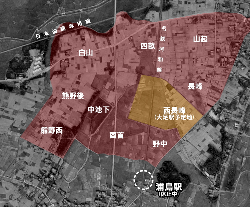
English: Nagoya Railroad Kōwa Line Ōashi Station Plan (fizzled out). 日本語: 名古屋鉄道 河和線 大足駅新設計画(実現せず) |
| 日期 | |
| 來源 |
|
| 作者 |
授權條款
[編輯]
|
本檔案的著作權持有者,Ministry of Land, Infrastructure, Transport and Tourism,在註明所有人姓名的前提下,允許任何人使用本檔案於任何用途。包含再散布、衍生作品、商業用途及其他用途。 |
姓名標示:
National Land Image Information (Color Aerial Photographs), created by Ministry of Land, Infrastructure, Transport and Tourism, distributed by Geospatial Information Authority of Japan
|

檔案歷史
點選日期/時間以檢視該時間的檔案版本。
| 日期/時間 | 縮圖 | 尺寸 | 使用者 | 備註 | |
|---|---|---|---|---|---|
| 目前 | 2020年2月5日 (三) 17:53 | | 838 × 694(421 KB) | ButuCC(留言 | 貢獻) | {{Information |description={{en|1=Nagoya Railroad Kōwa Line Ōashi Station Plan (fizzled out).}}{{ja|1=名古屋鉄道 河和線 大足駅新設計画(実現せず)}} |date=1959-11-26 |source= *国土交通省「国土画像情報(カラー空中写真)」(配布元:国土地理院地図・空中写真閲覧サービス) **[https://mapps.gsi.go.jp/maplibSearch.do?specificationId=734047 整理番号 KK592YZ-P20B-289] |author={{ja|国土地理院、ButuCCが加工。}} {{en|Geospatial Information Authority of Japan, modified by ButuCC}} |permissi... |
無法覆蓋此檔案。
檔案用途
下列3個頁面有用到此檔案: