File:青ヶ島.jpg
跳至導覽
跳至搜尋
預覽大小:480 × 599 像素。 其他解析度:192 × 240 像素 | 385 × 480 像素 | 615 × 768 像素 | 821 × 1,024 像素 | 1,641 × 2,048 像素 | 5,619 × 7,011 像素。
原始檔案 (5,619 × 7,011 像素,檔案大小:5.17 MB,MIME 類型:image/jpeg)
說明
說明
添加單行說明來描述出檔案所代表的內容
摘要
[編輯]| 描述 |
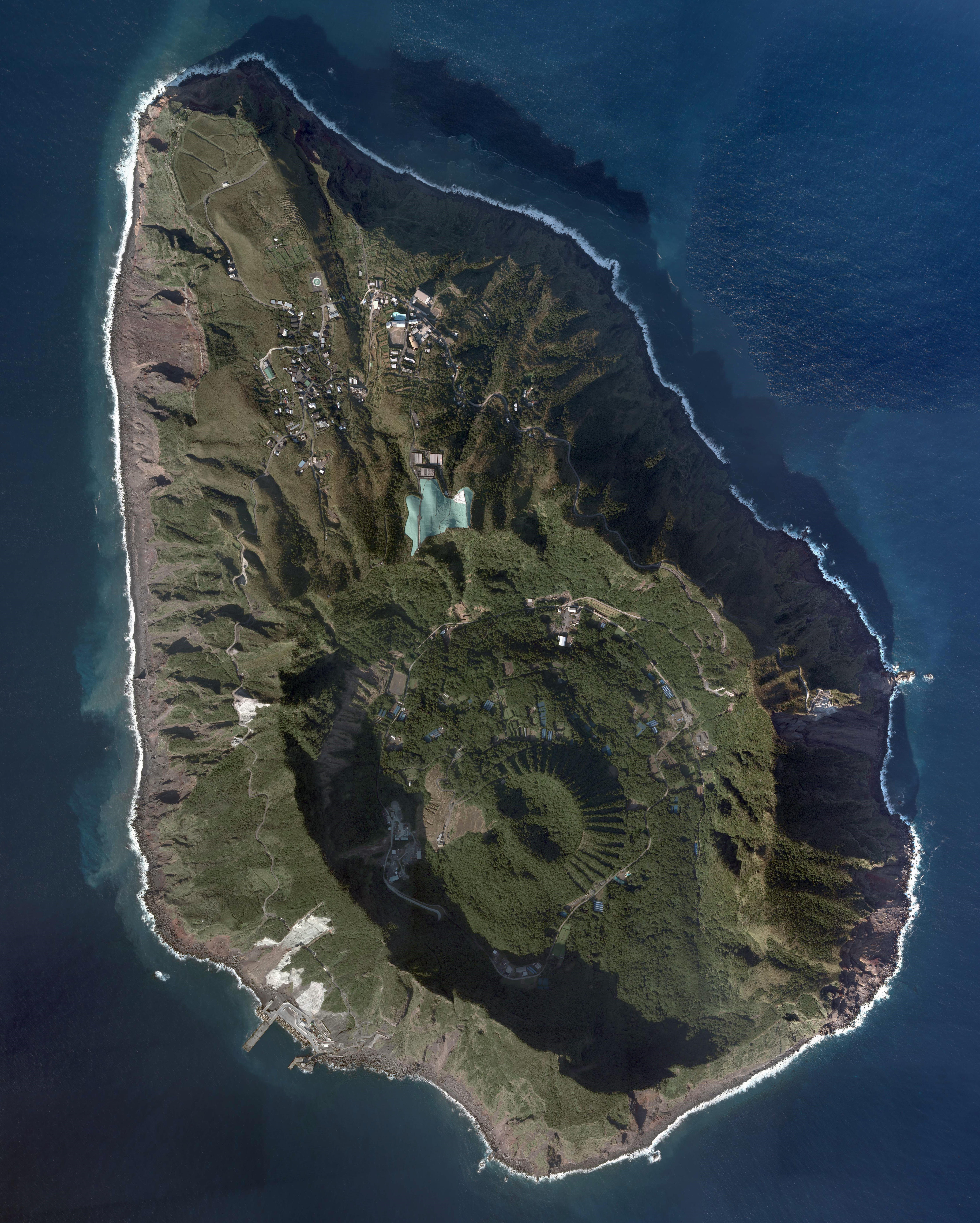
日本語: 青ヶ島の航空写真。国土地理院の地図・空中写真閲覧サービスより
|
| 日期 | |
| 來源 | http://mapps.gsi.go.jp/maplibSearch.do#1 |
| 作者 | 国土地理院 |
授權條款
[編輯]
|
本檔案的著作權持有者,Ministry of Land, Infrastructure, Transport and Tourism,在註明所有人姓名的前提下,允許任何人使用本檔案於任何用途。包含再散布、衍生作品、商業用途及其他用途。 |
姓名標示:
National Land Image Information (Color Aerial Photographs), created by Ministry of Land, Infrastructure, Transport and Tourism, distributed by Geospatial Information Authority of Japan
|

檔案歷史
點選日期/時間以檢視該時間的檔案版本。
| 日期/時間 | 縮圖 | 尺寸 | 用戶 | 備註 | |
|---|---|---|---|---|---|
| 目前 | 2019年7月11日 (四) 03:38 | | 5,619 × 7,011(5.17 MB) | Nux-vomica 1007(對話 | 貢獻) | 修正・トリミング |
| 2016年12月30日 (五) 07:53 |  | 8,128 × 8,102(41.53 MB) | Nux-vomica 1007(對話 | 貢獻) | 修正 | |
| 2016年12月30日 (五) 07:22 |  | 8,223 × 8,563(44.33 MB) | Nux-vomica 1007(對話 | 貢獻) | User created page with UploadWizard |
無法覆蓋此檔案。
檔案用途
全域檔案使用狀況
以下其他 wiki 使用了這個檔案:
- ca.wikipedia.org 的使用狀況
- en.wikipedia.org 的使用狀況
- es.wikipedia.org 的使用狀況
- fa.wikipedia.org 的使用狀況
- fr.wikipedia.org 的使用狀況
- id.wikipedia.org 的使用狀況
- ja.wikipedia.org 的使用狀況
- nl.wikipedia.org 的使用狀況
- nl.wikivoyage.org 的使用狀況
- uk.wikipedia.org 的使用狀況
- zh-min-nan.wikipedia.org 的使用狀況
- zh.wikipedia.org 的使用狀況