File:016vallesmarineris reduced0.25.jpg

原始檔案 (6,000 × 2,600 像素,檔案大小:8.88 MB,MIME 類型:image/jpeg)
說明
說明
摘要
[編輯]
| 描述 |
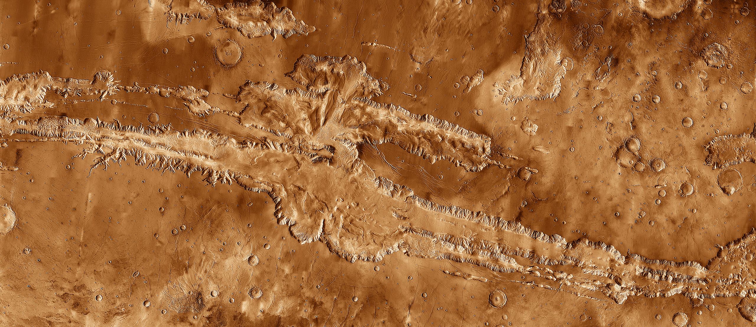
English: A ragged geological scar crosses the belly of Mars. Long enough to reach from New York City to Los Angeles, this great rift in the martian crust is named Valles Marineris, or Mariner Valley. It was discovered in 1972 by the Mariner 9 spacecraft. Formed out of several parallel, connecting troughs, Valles Marineris dwarfs Earth's Grand Canyon in every respect, being wider, longer, deeper, and older. It easily earns the title of Grandest Canyon of All.
This mosaic image of Valles Marineris - colored to resemble the martian surface - comes from the Thermal Emission Imaging System (THEMIS), a visible-light and infrared-sensing camera on NASA's Mars Odyssey orbiter. Mars Odyssey was built by Lockheed Martin and the mission is operated by the Jet Propulsion Laboratory. Built from more than 500 daytime infrared photos, the mosaic shows the whole valley in more detail than any previous composite photo. Despite the valley's huge extent - including its western extension through Noctis Labyrinthus, it reaches some 3,000 kilometers (2,000 miles) long - the smallest details visible in the image are about the size of a football field: 100 meters (328 feet). This is a reduced size (approximately one fourth the linear pixel density) and cropped (at the bottom) version of the original 23,711 x 11,856 pixel THEMIS mosaic, and has also been adjusted in hue and saturation. |
| 日期 | |
| 來源 | http://themis.asu.edu/vallesspecial |
| 作者 | NASA / JPL-Caltech / Arizona State University |
| 其他版本 |
016vallesmarineris reduced0.5.jpg - larger, uncropped version (12,000 × 6,000 pixels, 35.67 MB) |
授權條款
[編輯]
| 本作品由NASA創作,屬於公有領域。根據NASA的版權政策:“NASA的創作除非另有聲明否則不受版權保護。”(參見:Template:PD-USGov/zh,NASA版權政策或JPL圖像使用政策) | ||
 |
警告:
|
檔案歷史
點選日期/時間以檢視該時間的檔案版本。
| 日期/時間 | 縮圖 | 尺寸 | 用戶 | 備註 | |
|---|---|---|---|---|---|
| 目前 | 2012年9月16日 (日) 06:10 | | 6,000 × 2,600(8.88 MB) | WolfmanSF(對話 | 貢獻) | adjust hue, saturation |
| 2012年9月15日 (六) 23:16 |  | 6,000 × 2,600(8.17 MB) | WolfmanSF(對話 | 貢獻) | cropped at bottom | |
| 2012年9月15日 (六) 22:30 |  | 6,000 × 3,000(9.45 MB) | WolfmanSF(對話 | 貢獻) | User created page with UploadWizard |
無法覆蓋此檔案。
檔案用途
沒有使用此檔案的頁面。
全域檔案使用狀況
以下其他 wiki 使用了這個檔案:
- ar.wikipedia.org 的使用狀況
- ca.wikipedia.org 的使用狀況
- en.wikipedia.org 的使用狀況
- eu.wikipedia.org 的使用狀況
- fr.wikipedia.org 的使用狀況
- it.wikipedia.org 的使用狀況
- ja.wikipedia.org 的使用狀況
- ko.wikipedia.org 的使用狀況
- ml.wikipedia.org 的使用狀況
- mnw.wikipedia.org 的使用狀況
- pt.wikipedia.org 的使用狀況
- pt.wikibooks.org 的使用狀況
- sco.wikipedia.org 的使用狀況
- sr.wikipedia.org 的使用狀況
- th.wikipedia.org 的使用狀況
- tt.wikipedia.org 的使用狀況
- zh.wikipedia.org 的使用狀況
詮釋資料
- Valles Marineris
- Photos of Coprates quadrangle by THEMIS
- Ganges Catena
- Ceti Chasma
- Baetis Chasma
- Hydrae Chasma
- Hydrae Chaos
- Hydrae Cavus
- Ophir Catenae
- Juventae Cavi
- Juventae Chasma
- Dittaino Valles
- Sepik Vallis
- Juventae Dorsa
- Tithoniae Fossae
- Tithoniae Catenae
- Sinai Fossae
- Sinai Dorsa
- Nia Fossae
- Melas Dorsa
- Coprates Catena
- Ophir Cavus
- Ganges Cavus
- Allegheny Vallis
- Ophir Planum