File:02F 2018-11-11 2354Z.jpg
跳至導覽
跳至搜尋

預覽大小:471 × 599 像素。 其他解析度:189 × 240 像素 | 377 × 480 像素 | 604 × 768 像素 | 805 × 1,024 像素 | 1,610 × 2,048 像素 | 6,858 × 8,721 像素。
原始檔案 (6,858 × 8,721 像素,檔案大小:7.01 MB,MIME 類型:image/jpeg)
說明
說明
添加單行說明來描述出檔案所代表的內容
摘要
[編輯]
| 描述 |
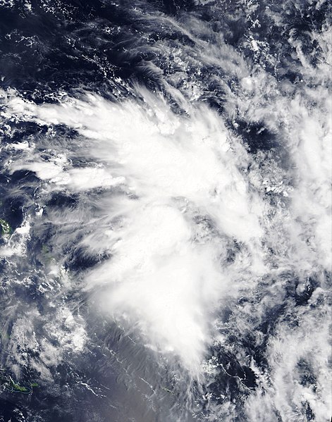
English: Tropical Disturbance 02F located in the far northwestern part of the South Pacific tropical cyclone basin just after being classified by the Fiji Meteorological Service on 11 November 2018. The Solomon Islands are just visible in the lower left-hand portion of the image. |
| 日期 | |
| 來源 | NASA Worldview |
| 作者 | National Aeronautics and Space Administration (NASA) - 'Terra' satellite |
| 拍攝地點 | | 位於此地的本圖片與其他圖片: OpenStreetMap |
|---|
授權條款
[編輯]
| 本作品由NASA創作,屬於公有領域。根據NASA的版權政策:“NASA的創作除非另有聲明否則不受版權保護。”(參見:Template:PD-USGov/zh,NASA版權政策或JPL圖像使用政策) | ||
 |
警告:
|
檔案歷史
點選日期/時間以檢視該時間的檔案版本。
| 日期/時間 | 縮圖 | 尺寸 | 使用者 | 備註 | |
|---|---|---|---|---|---|
| 目前 | 2018年11月12日 (一) 06:40 | | 6,858 × 8,721(7.01 MB) | ChocolateTrain(留言 | 貢獻) | User created page with UploadWizard |
無法覆蓋此檔案。
檔案用途
沒有使用此檔案的頁面。
全域檔案使用狀況
以下其他 wiki 使用了這個檔案:
- en.wikipedia.org 的使用狀況
- pt.wikipedia.org 的使用狀況
- th.wikipedia.org 的使用狀況
- zh.wikipedia.org 的使用狀況