File:1598 map of the Polar Regions by Willem Barentsz.jpg
Μετάβαση στην πλοήγηση
Πήδηση στην αναζήτηση

Μέγεθος αυτής της προεπισκόπησης: 800 × 592 εικονοστοιχεία . Άλλες αναλύσεις: 320 × 237 εικονοστοιχεία | 640 × 474 εικονοστοιχεία | 1.024 × 758 εικονοστοιχεία | 1.280 × 948 εικονοστοιχεία | 2.560 × 1.896 εικονοστοιχεία | 13.719 × 10.160 εικονοστοιχεία.
Πρωτότυπο αρχείο (13.719 × 10.160 εικονοστοιχεία, μέγεθος αρχείου: 30,66 MB, τύπος MIME: image/jpeg)
Λεζάντες
Λεζάντες
Δεν ορίστηκε λεζάντα
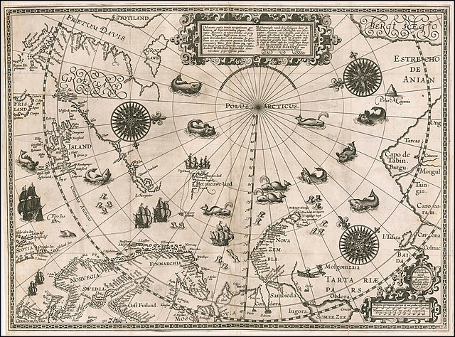
1598 map of the Polar Regions by Willem Barentsz
Σύνοψη
[επεξεργασία]| Περιγραφή |
English: 1598 map of the Polar Regions by Willem Barentsz
Latina: Deliniatio cartae trium navigationum per Batavos, ad Septentrionalem plagam, Norvegiae, Moscoviae, et novae Semblae, et perque fretum Weygatis Nassovicum dictum, ac juxta Groenlandiam, sub altitudine 80. graduum nec non adiacentium partium Tartariae, promontorij Tabin, freti Anian atque regionis Bargi et partis Americae versus orientem, Authore Wilhelmo Bernardo Amstelredamo experissimo pilota.
Nederlands: Beschryvinghe vande drie seylagien door de Hollanders gedaen ande Noordt syde van Noorweghen, Moscovia, nova Sembla, ende door de Weygats ofte Strate de Nassou so mede het' deel van Groenlandt op de 80. graeden ende de omleggende grensen van Tartaryen, ende de Capo de Tabin ende des landtschaps Bargi, so oock het Oostersche deel van America: door Willem Barents van Amstelredam de vermaerde Piloot |
| Ημερομηνία | |
| Πηγή | Barry Lawrence Rare Maps, from an original 1598 print. |
| Δημιουργός | Original charts by Willem Barentsz, map drawn by Cornelis Claesz ("Cornelius Nicolai"), engraved by Baptista van Doetecum ("Baptista a Doetechum") |
| άλλες εκδόσεις |
|
.jpg)

_door_Willem_Barendsz_(titel_op_object),_NG-800.jpg)


Αδειοδότηση
[επεξεργασία]
|
Αυτό το έργο είναι κοινό κτήμα στη χώρα προέλευσής του και άλλες χώρες και περιοχές όπου η διάρκεια πνευματικών δικαιωμάτων είναι όσο η ζωή του δημιουργού και μέχρι 70 χρόνια μετά ή λιγότερο. Αυτό το έργο είναι κοινό κτήμα στις Ηνωμένες Πολιτείες επειδή δημοσιεύτηκε (ή καταχωρήθηκε στο U.S. Copyright Office) πριν την 1 Ιανουαρίου 1929. | |
| Αυτό το αρχείο έχει χαρακτηριστεί ως απαλλαγμένο από γνωστούς περιορισμούς βάσει της νομοθεσίας περί πνευματικής ιδιοκτησίας, περιλαμβανομένων όλων των συναφών και συγγενικών δικαιωμάτων. | |
| Annotations | This image is annotated: View the annotations at Commons |
Ιστορικό αρχείου
Πατήστε σε μια ημερομηνία/ώρα για να δείτε το αρχείο όπως εμφανιζόταν εκείνη την χρονική στιγμή.
| Ημερομηνία/Ώρα | Μικρογραφία | Διαστάσεις | Χρήστης | Σχόλιο | |
|---|---|---|---|---|---|
| τρέχον | 18:42, 22 Μαρτίου 2020 | | 13.719 × 10.160 (30,66 MB) | Balkanique (συζήτηση | Συνεισφορά) | Uploaded a work by Willem Barentsz from https://www.raremaps.com/gallery/detail/59238/deliniatio-cartae-trium-navigationum-per-batavos-ad-septent-barentsz with UploadWizard |
Δεν μπορείτε να αντικαταστήσετε αυτό το αρχείο.
Χρήση αρχείου
Οι ακόλουθες 9 σελίδες χρησιμοποιούν προς αυτό το αρχείο:
- Arctic
- File:Barents third voyage.jpg
- File:Barentskartet, 1598 (12068020364).jpg
- File:Barentsz Full Map.jpg
- File:Barentsz arctic map.jpg
- File:Forminsket utgave av Barentskartet - no-nb krt 00487.jpg
- File:Kaart van de landen rond de poolcirkel met de drie reizen van de Nederlanders, 1598 Beschrijvinghe van de drie seylagien door de Hollanders gedaen ande Noordt syde van Noorweghen, Moscovia, nova Sembla, ende door het de, RP-P-OB-80.320.jpg
- File:Kaart van het Noordpoolgebied, 1598 Beschrijvinghe van de drie seylagien door de Hollanders gedaan (..) door Willem Barendsz (titel op object), NG-800.jpg
- File:Pontanus 1611 Arctic Map.jpg
Καθολική χρήση αρχείου
Τα ακόλουθα άλλα wiki χρησιμοποιούν αυτό το αρχείο:
- Χρήση σε ar.wikipedia.org
- Χρήση σε ast.wikipedia.org
- Χρήση σε ca.wikipedia.org
- Χρήση σε cs.wikipedia.org
- Χρήση σε da.wikipedia.org
- Χρήση σε de.wikipedia.org
- Χρήση σε en.wikipedia.org
- Χρήση σε es.wikipedia.org
- Χρήση σε fr.wikipedia.org
- Χρήση σε hy.wikipedia.org
- Χρήση σε is.wikipedia.org
- Χρήση σε it.wikipedia.org
- Χρήση σε ja.wikipedia.org
- Χρήση σε la.wikipedia.org
- Χρήση σε nl.wikipedia.org
- Χρήση σε no.wikipedia.org
- Χρήση σε pl.wikipedia.org
- Χρήση σε pt.wikipedia.org
- Χρήση σε sl.wikipedia.org
- Χρήση σε sr.wikipedia.org
- Χρήση σε uk.wikipedia.org
- Χρήση σε vi.wikipedia.org
- Χρήση σε zh.wikipedia.org
Κατηγορίες:
- Third voyage of Willem Barentsz
- History of Dutch sea fisheries
- 1598 maps
- 1598 maps of Russia
- Historical maps of Spitsbergen
- Old maps of Scandinavia
- Maps of Novaya Zemlya
- Old maps of the Arctic
- Old maps of the White Sea
- Maps of the Barents Sea
- Maps of the Greenland Sea
- Old maps of the Arctic Ocean
- Old maps of Svalbard
- 1590s maps of Norway
- 1590s maps of Sweden
- 1590s maps of Denmark
- 1590s maps of Iceland
- 1590s maps of Greenland
- 1590s maps of Scotland
- Magnetic pole
- Strait of Anian
- Davis Strait
- Frobisher Bay
- Terra incognita
- Phantom islands
- Latin-language maps
- Dutch-language maps
- Animals on maps
- Whales on maps
- Monsters on maps
- Seals in art
- Maps of the Kara Sea
- Maps of the Beaufort Sea
- Maps of Baffin Bay
- Maps of the East Siberian Sea
- Maps of the Laptev Sea
- Maps of the Chukchi Sea
- 1590s maps of Finland
- Baptista van Doetecum
- Cornelis Claesz
- Maps of voyages
- Maps of the North Pole
- Reindeer sleds in art
- Northern Sea Route
- 16th-century maps of the Arctic