File:1825 Prairie du Chien Line.jpg
Sautar la navigacion
Sautar la recèrca

Talha d'aquesta previsualizacion: 463 × 599 pixèls. Autras resolucions : 185 × 240 pixèls | 371 × 480 pixèls | 593 × 768 pixèls | 1 275 × 1 650 pixèls.
Fichièr d'origina (1 275 × 1 650 pixèl, talha del fichièr: 495 Ko, tipe MIME: image/jpeg)
Llegendes
Llegendes
Afegeix una explicació d'una línia del que representa aquest fitxer
Descripcion[modificar]
| Descripcion |
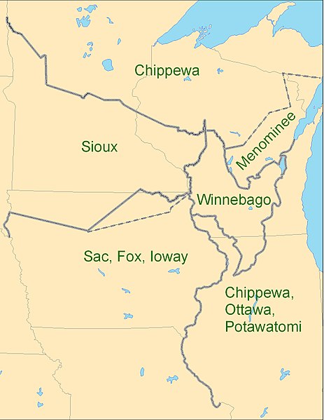
English: Map showing the boundaries between the Sioux (Dakota), Chippewa (Ojibwe), Winnebago (Ho-chunk), Menominee (Menomini), Sauk and Fox (Sac and Fox Nation), Ioway, and the Chippewa-Ottawa-Potawatomi (Council of Three Fires) as per 1825 Treaty of Prairie du Chien |
| Data | |
| Font | Trabalh personal |
| Autor | CJLippert |
Due to uncertainty of Menominee and Ioway boundaries, the parties agreed to adjustments to the 1825-established Prairie du Chien Line once the Menominee and Ioway have determined their boundaries. The adjustment lines shown as dashed boundaries.
Publicat jos licéncia(s)[modificar]
Ieu, autor d'aquesta òbra, publiqui jos la licéncia seguenta:
Aqueste fichièr es jos licéncia Creative Commons paternitat 3.0 unported
- Sètz liure :
- de partejar – de copiar, distribuir e transmetre aquesta òbra
- d'adaptar – d'adaptar aquesta òbra
- Jos las condicions seguentas :
- atribucion – Vos cal atribuir aquesta òbra amb lo biais especificat per l'autor o lo concedent (mas pas dins un sens que suggerís que vos apròvan o qu'apròvan l'utilizacion d'aquesta òbra).
Istoric del fichièr
Clicar sus una data e una ora per veire lo fichièr tal coma èra a aqueste moment
| Data e ora | Miniatura | Dimensions | Utilizaire | Comentari | |
|---|---|---|---|---|---|
| actual | 3 setembre de 2009 a 19.26 | | 1 275 × 1 650 (495 Ko) | CJLippert (discussion | contribucions) | {{Information |Description={{en|1=Map showing the boundaries between the Sioux (w:Dakota), Chippewa (w:Ojibwe), Winnebago (w:Ho-chunk), Menominee (w:Menomini), Sauk and Fox (w:Sac and Fox Nation), w:Ioway, and the Chippewa-Ottawa-P |
Podètz pas remplaçar aqueste fichièr.
Paginas que contenon lo fichièr
I a ges de pagina que compòrta un ligam vèrs aqueste imatge.
Usatge global del fichièr
Los autres wikis seguents utilizan aqueste imatge :
- Utilizacion sus ca.wikipedia.org
- Utilizacion sus en.wikipedia.org
- Utilizacion sus en.wikiversity.org
- Utilizacion sus es.wikipedia.org
- Utilizacion sus fr.wikipedia.org
- Utilizacion sus hr.wikipedia.org
- Utilizacion sus nl.wikipedia.org
- Utilizacion sus oc.wikipedia.org
- Utilizacion sus sv.wikipedia.org
- Utilizacion sus uk.wikipedia.org
Categorias :
- Maps of Native American tribal territories
- Ojibwe maps
- Potawatomi
- Sioux maps
- Ho-chunk
- Sac and Fox maps
- Menominee
- Maps of the history of Minnesota
- Maps of the history of Wisconsin
- Maps of the history of Illinois
- Maps of Iowa
- First Treaty of Prairie du Chien
- History of indigenous peoples of the Great Lakes Region
- Maps of the Midwestern United States
- 1820s maps of the United States