File:1827 Williamsburg Map.jpg

元のファイル (7,721 × 5,171 ピクセル、ファイルサイズ: 24.3メガバイト、MIME タイプ: image/jpeg)
キャプション
キャプション
概要[編集]
| 解説 |
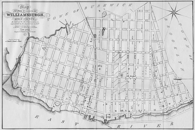
English: Map of the Village of Williamsburgh, Kings County; As laid out by the Commissioners, appointed by the Legislature in 1827. Reduced from the large Map in the possession of the Trustees of the Village. Surveyed by D. Ewin. New York, Engraved & Published by H. McDowell, 1833.
The Bushwick Creek, which originally separated Williamsburg from Greenpoint, has since been filled in. Today, much of the filled in land along Bushwick Creek makes up McCarren Park. Bushwick Inlet still exists near N 13th and N 14th Streets. Streets names on the map and their modern day names: Turnpike Road to Jamaica => Metropolitan Ave Water Street => River Street First Street => Kent Ave Second Street => Wythe Ave Third Street => Berry Street Fourth Street => Bedford Ave Fifth Street => Driggs Ave Sixth Street => Roebling Street Seventh Street => Havemeyer Street Eighth Street => Marcy Ave Ninth Street => Rodney Street Tenth Street => Keap Street |
| 日付 | |
| 原典 | スキャナで取り込み |
| 作者 | H. McDowell |
| 許可 (ファイルの再利用) |
public domain |
ライセンス[編集]
|
この著作物は、著作権の保護期間が著作者の死後70年以下である国・地域においてパブリックドメインの状態にあります。
| |
| このファイルは著作権法の既知の制約(隣接権や関連する権利を含む)から自由であると特定されています。 | |
ファイルの履歴
過去の版のファイルを表示するには、その版の日時をクリックしてください。
| 日付と時刻 | サムネイル | 寸法 | 利用者 | コメント | |
|---|---|---|---|---|---|
| 現在の版 | 2009年3月9日 (月) 15:40 | | 7,721 × 5,171 (24.3メガバイト) | Repliedthemockturtle (トーク | 投稿記録) | {{Information |Description={{en|1=A Map of the Village of Williamsburg, Kings County, NY, showing each lot of ground in said village, as laid on the assessment maps of the village, together with the new assessment number of each lot. The village is divid |
このファイルは上書きできません。
ファイルの使用状況
以下のページがこのファイルを使用しています:
グローバルなファイル使用状況
以下に挙げる他のウィキがこの画像を使っています:
- da.wikipedia.org での使用状況
- en.wikipedia.org での使用状況
- ja.wikipedia.org での使用状況