File:1850 IC.jpg
跳转到导航
跳转到搜索

本预览的尺寸:362 × 600像素。 其他分辨率:145 × 240像素 | 290 × 480像素 | 464 × 768像素 | 618 × 1,024像素 | 1,236 × 2,048像素 | 3,536 × 5,856像素。
原始文件 (3,536 × 5,856像素,文件大小:2.99 MB,MIME类型:image/jpeg)
说明
说明
添加一行文字以描述该文件所表现的内容
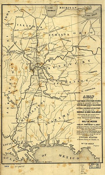
Map of the Illinois Central Railroad and New Orleans and Ohio Railroad (1850) and proposed Capitol City
1850 map of the Illinois Central Railroad and New Orleans and Ohio Railroad (which became part of the IC) from [1]. Also shows the Mobile and Ohio Railroad, later part of the Gulf, Mobile and Ohio Railroad. Also shows the proposed "Western District of Columbia" where the two lines would meet, including Metropolis, Illinois and the never-built Capitol City, Kentucky.
|
本作品在其来源国以及其他著作权期限是作者逝世后70年或以下的国家和地区属于公有领域。 | |
| 本文件已被确认为免除已知的著作权法限制(包括所有相关权利)。 | |
文件历史
点击某个日期/时间查看对应时刻的文件。
| 日期/时间 | 缩略图 | 大小 | 用户 | 备注 | |
|---|---|---|---|---|---|
| 当前 | 2005年8月26日 (五) 12:13 | | 3,536 × 5,856(2.99 MB) | SPUI~commonswiki(留言 | 贡献) | {{PD}} 1850 map of the Illinois Central Railroad and New Orleans and Ohio Railroad (which became part of the IC) from [http://memory.loc.gov/cgi-bin/query/r?ammem/gmd:@field(NUMBER+@band(g4041p+rr004740))]. Also shows the Mobile and Ohio Railroad, later p |
您不可以覆盖此文件。
文件用途
没有页面使用本文件。
全域文件用途
以下其他wiki使用此文件:
- de.wikipedia.org上的用途
- en.wikipedia.org上的用途
- eo.wikipedia.org上的用途
- ja.wikipedia.org上的用途
- zh.wikipedia.org上的用途