File:1860 Colorado Territory map.svg
跳至導覽
跳至搜尋

此 SVG 檔案的 PNG 預覽的大小:448 × 303 像素。 其他解析度:320 × 216 像素 | 640 × 433 像素 | 1,024 × 693 像素 | 1,280 × 866 像素 | 2,560 × 1,731 像素。
原始檔案 (SVG 檔案,表面大小:448 × 303 像素,檔案大小:107 KB)
說明
說明
添加單行說明來描述出檔案所代表的內容
摘要
[編輯]
| 描述 |
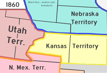
English: A map of Colorado Territory in 1860. Based off File:Wpdms kansas nebraska utah territories 1860 idx.png |
| 日期 | |
| 來源 | 自己的作品 |
| 作者 | Rcsprinter123 |
| 其他版本 |
 |
| SVG開發 |
授權條款
[編輯]
| 我,此作品的版權所有人,釋出此作品至公共領域。此授權條款在全世界均適用。 這可能在某些國家不合法,如果是的話: 我授予任何人有權利使用此作品於任何用途,除受法律約束外,不受任何限制。 |
檔案歷史
點選日期/時間以檢視該時間的檔案版本。
| 日期/時間 | 縮圖 | 尺寸 | 使用者 | 備註 | |
|---|---|---|---|---|---|
| 目前 | 2023年6月2日 (五) 10:10 | | 448 × 303(107 KB) | Rcsprinter123(留言 | 貢獻) | == {{int:filedesc}} == {{Information |Description = {{en|1=A map of Colorado Territory in 1860. Based off File:Wpdms kansas nebraska utah territories 1860 idx.png }} |Source = {{own}} |Author = {{u|Rcsprinter123}} |other fields={{Igen|Inkscape|+}} |Date = 2013-08-24 |Permission = |other_versions = 140px }} == {{int:license-header}} == {{PD-self}} [[Category:Maps of f... |
無法覆蓋此檔案。
檔案用途
下列3個頁面有用到此檔案:
全域檔案使用狀況
以下其他 wiki 使用了這個檔案:
- ca.wikipedia.org 的使用狀況
- en.wikipedia.org 的使用狀況
- es.wikipedia.org 的使用狀況
- fi.wikipedia.org 的使用狀況
- he.wikipedia.org 的使用狀況
- ig.wikipedia.org 的使用狀況
- it.wikipedia.org 的使用狀況
- ko.wikipedia.org 的使用狀況
- pt.wikipedia.org 的使用狀況
- ru.wikipedia.org 的使用狀況
- tum.wikipedia.org 的使用狀況
- vi.wikipedia.org 的使用狀況
- zh.wikipedia.org 的使用狀況