File:1902-pelee-map.jpg
跳至導覽
跳至搜尋

預覽大小:402 × 600 像素。 其他解析度:161 × 240 像素 | 321 × 480 像素 | 804 × 1,200 像素。
原始檔案 (804 × 1,200 像素,檔案大小:870 KB,MIME 類型:image/jpeg)
說明
說明
添加單行說明來描述出檔案所代表的內容
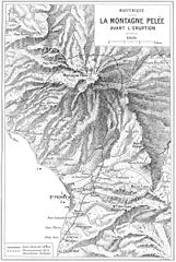
Alfred LaCroix. La Montagne Pelee et ses Eruptions. Paris, Masson et Cie, 1904. A relief map of Mount Pelee (Montagne Pelee in French) showing the area affected by the eruptions of 8 May and 30 August, 1902. The map is from page 223.
|
本作品在其來源國以及其他著作權期限是作者逝世後70年或以下的國家與地區屬於公有領域。
| |
| 此作品無已知的著作權限制,亦不受所有相關和鄰接的權利限制。 | |
檔案歷史
點選日期/時間以檢視該時間的檔案版本。
| 日期/時間 | 縮圖 | 尺寸 | 使用者 | 備註 | |
|---|---|---|---|---|---|
| 目前 | 2005年10月14日 (五) 04:41 | | 804 × 1,200(870 KB) | Jerry7171(留言 | 貢獻) | Alfred LaCroix. La Montagne Pelee et ses Eruptions. Paris, Masson et Cie, 1904. A relief map of Mount Pelee (Montagne Pelee in French) showing the area affected by the eruptions of 8 May and 3 August, 1902. The map is from page 223. |
無法覆蓋此檔案。
檔案用途
沒有使用此檔案的頁面。
全域檔案使用狀況
以下其他 wiki 使用了這個檔案:
- ast.wikipedia.org 的使用狀況
- ca.wikipedia.org 的使用狀況
- cs.wikipedia.org 的使用狀況
- en.wikipedia.org 的使用狀況
- es.wikipedia.org 的使用狀況
- fi.wikipedia.org 的使用狀況
- fr.wikipedia.org 的使用狀況
- gl.wikipedia.org 的使用狀況
- ja.wikipedia.org 的使用狀況
- lv.wikipedia.org 的使用狀況
- ms.wikipedia.org 的使用狀況
- pl.wikipedia.org 的使用狀況
- pt.wikipedia.org 的使用狀況
- vi.wikipedia.org 的使用狀況
- zh.wikipedia.org 的使用狀況