File:1933 Hurricane Seventeen analysis 5 Oct.png
跳至導覽
跳至搜尋

預覽大小:691 × 600 像素。 其他解析度:277 × 240 像素 | 553 × 480 像素 | 885 × 768 像素 | 1,244 × 1,080 像素。
原始檔案 (1,244 × 1,080 像素,檔案大小:832 KB,MIME 類型:image/png)
說明
說明
添加單行說明來描述出檔案所代表的內容
摘要[編輯]
| 描述 |
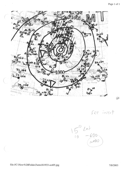
English: Surface weather analysis of the seventeenth hurricane of the 1933 Atlantic hurricane season. At the time, the tropical cyclone was tracking to the northeast within the Florida Strait and had just intensified into the equivalent of a modern-day Category 3 hurricane. |
| 日期 | |
| 來源 | http://www.aoml.noaa.gov/hrd/hurdat/weathermaps/193317-oct5.jpg |
| 作者 | NOAA Central Library, Hurricane Research Division |
授權條款[編輯]
本圖像屬於公有領域,因該作品最初來自於美國國家海洋和大氣管理局職員的職務作品。
|
檔案歷史
點選日期/時間以檢視該時間的檔案版本。
| 日期/時間 | 縮圖 | 尺寸 | 用戶 | 備註 | |
|---|---|---|---|---|---|
| 目前 | 2016年9月24日 (六) 21:33 | | 1,244 × 1,080(832 KB) | Cmdrjameson(對話 | 貢獻) | Compressed with pngout. Reduced by 519kB (38% decrease). |
| 2013年9月30日 (一) 02:36 |  | 1,244 × 1,080(1.32 MB) | TheAustinMan(對話 | 貢獻) | User created page with UploadWizard |
無法覆蓋此檔案。
檔案用途
沒有使用此檔案的頁面。
全域檔案使用狀況
以下其他 wiki 使用了這個檔案:
- en.wikipedia.org 的使用狀況
- zh.wikipedia.org 的使用狀況