File:1995 North Indian Ocean cyclone season summary map.png
পরিভ্রমণে চলুন
অনুসন্ধানে চলুন

এই প্রাকদর্শনের আকার: ৮০০ × ৪৯৪ পিক্সেল। অন্যান্য আকারসমূহ: ৩২০ × ১৯৮ পিক্সেল | ৬৪০ × ৩৯৬ পিক্সেল | ১,০২৪ × ৬৩৩ পিক্সেল | ১,২৮০ × ৭৯১ পিক্সেল | ২,৫৬০ × ১,৫৮২ পিক্সেল | ৪,০০০ × ২,৪৭২ পিক্সেল।
মূল ফাইল (৪,০০০ × ২,৪৭২ পিক্সেল, ফাইলের আকার: ১১.৫৫ মেগাবাইট, এমআইএমই ধরন: image/png)
ক্যাপশনসমূহ
ক্যাপশন
এই ফাইল কি প্রতিনিধিত্ব করছে তার এক লাইন ব্যাখ্যা যোগ করুন
সারাংশ
[সম্পাদনা]
| বিবরণ |
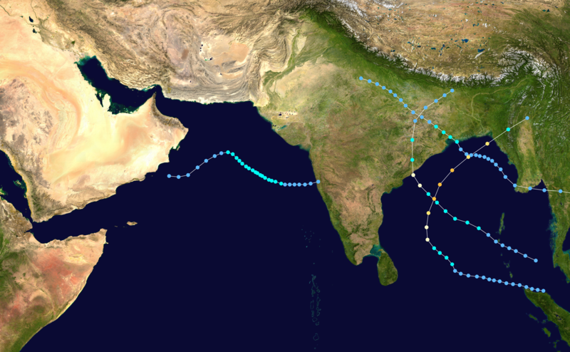
English: This map shows the tracks of all tropical cyclones in the 1995 North Indian Ocean cyclone season. The points show the location of each storm at 6-hour intervals. The colour represents the storm's maximum sustained wind speeds as classified in the Saffir-Simpson Hurricane Scale (see below), and the shape of the data points represent the type of the storm. Map generation parameters: --xmin 40 --xmax 100 --ymin 0 --ymax 35
Tropical depression (≤38 mph, ≤62 km/h)
Tropical storm (39–73 mph, 63–118 km/h)
Category 1 (74–95 mph, 119–153 km/h)
Category 2 (96–110 mph, 154–177 km/h)
Category 3 (111–129 mph, 178–208 km/h)
Category 4 (130–156 mph, 209–251 km/h)
Category 5 (≥157 mph, ≥252 km/h)
Unknown
Storm type |
| উৎস | Created using Wikipedia:WikiProject Tropical cyclones/Tracks. The background image is from NASA [1]. The tracking data is from the Joint Typhoon Warning Center's best track database |
| লেখক | Cyclonebiskit |
| এই কাজের প্রণেতা Cyclonebiskit কাজটি পাবলিক ডোমেইনে প্রকাশ করেছেন। এটি বিশ্বব্যাপী প্রযোজ্য হবে। কিছু দেশে এটি আইনত সিদ্ধ নাও হতে পারে, যদি তাই হয়: Cyclonebiskit যে-কাউকে যেকোনো উদ্দেশ্যে, বিনাশর্তে এই কাজটি ব্যবহারের অনুমতি প্রদান করেন, যদি না সেই শর্তগুলো আইনত প্রয়োজনীয় হয়। |
ফাইলের ইতিহাস
যেকোনো তারিখ/সময়ে ক্লিক করে দেখুন ফাইলটি তখন কী অবস্থায় ছিল।
| তারিখ/সময় | সংক্ষেপচিত্র | মাত্রা | ব্যবহারকারী | মন্তব্য | |
|---|---|---|---|---|---|
| বর্তমান | ১০:৫১, ১৬ ফেব্রুয়ারি ২০১৬ | | ৪,০০০ × ২,৪৭২ (১১.৫৫ মেগাবাইট) | Cyclonebiskit (আলোচনা | অবদান) | == {{int:filedesc}} == {{Hurricane season auto track map|start=September 12, 1995|end=November 25, 1995|source=JTWC|type=cyclone|basin=North Indian Ocean|year=1995|comments= Map generation parameters: <tt>--xmin 40 --xmax 100 --ymin 0 --ymax 35</t... |
আপনি এই ফাইলটি প্রতিস্থাপন করতে পারবেন না।
ফাইলের ব্যবহার
নিম্নলিখিত পাতাটি এই ফাইল ব্যবহার করে:
ফাইলের বৈশ্বিক ব্যবহার
নিচের অন্যান্য উইকিগুলো এই ফাইলটি ব্যবহার করে:
- bn.wikipedia.org-এ ব্যবহার
- en.wikipedia.org-এ ব্যবহার