File:2000census- Black Residential Segregation.JPG
跳转到导航
跳转到搜索
没有更高的分辨率。
2000census-_Black_Residential_Segregation.JPG (700 × 558像素,文件大小:233 KB,MIME类型:image/jpeg)
说明
说明
添加一行文字以描述该文件所表现的内容
摘要
[编辑]
| 描述 |
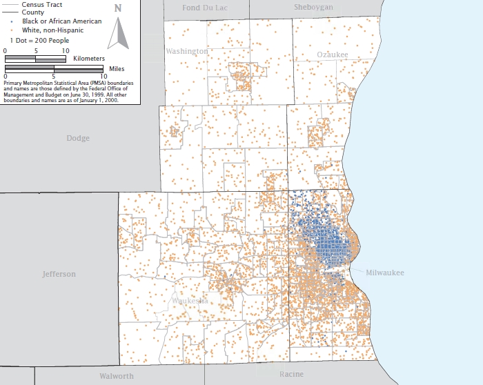
English: A map showing residential black segregation in the 2000 Census' most segregated American city, Milwaukee, Wisconsin. |
| 日期 | |
| 来源 | US Census Bureau (https://www.census.gov/hhes/www/housing/housing_patterns/pdf/Fig5-3.pdf) |
| 作者 | US Census Bureau, 2000 Census |
许可协议
[编辑]
This image or file is a work of a United States Census Bureau employee, taken or made as part of that person's official duties. As a work of the U.S. federal government, the image is in the public domain.
|
 |
文件历史
点击某个日期/时间查看对应时刻的文件。
| 日期/时间 | 缩略图 | 大小 | 用户 | 备注 | |
|---|---|---|---|---|---|
| 当前 | 2009年10月2日 (五) 05:07 | | 700 × 558(233 KB) | Jim37hike(留言 | 贡献) | {{Information |Description={{en|1=A map showing residential black segregation in the 2000 Census' most segregated American city, Milwaukee, Wisconsin.}} |Source=US Census Bureau (http://www.census.gov/hhes/www/housing/housing_patterns/pdf/Fig5-3.pdf) |Aut |
您不可以覆盖此文件。
文件用途
没有页面使用本文件。
全域文件用途
以下其他wiki使用此文件:
- en.wikipedia.org上的用途
- zh.wikipedia.org上的用途