File:2006 Pacific typhoon season summary map.png
Zur Navigation springen
Zur Suche springen

Größe dieser Vorschau: 800 × 600 Pixel. Weitere Auflösungen: 320 × 240 Pixel | 640 × 480 Pixel | 1.024 × 768 Pixel | 1.280 × 960 Pixel | 2.560 × 1.920 Pixel | 4.000 × 3.000 Pixel.
Originaldatei (4.000 × 3.000 Pixel, Dateigröße: 7,53 MB, MIME-Typ: image/png)
Bildtexte
Kurzbeschreibungen
Ergänze eine einzeilige Erklärung, was diese Datei darstellt.
| Beschreibung |
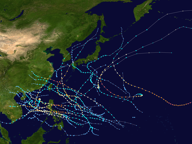
English: This map shows the tracks of all tropical cyclones in the 2006 Pacific typhoon season. The points show the location of each storm at 6-hour intervals. The colour represents the storm's maximum sustained wind speeds as classified in the Saffir-Simpson Hurricane Scale (see below), and the shape of the data points represent the type of the storm.
Tropical depression (≤38 mph, ≤62 km/h)
Tropical storm (39–73 mph, 63–118 km/h)
Category 1 (74–95 mph, 119–153 km/h)
Category 2 (96–110 mph, 154–177 km/h)
Category 3 (111–129 mph, 178–208 km/h)
Category 4 (130–156 mph, 209–251 km/h)
Category 5 (≥157 mph, ≥252 km/h)
Unknown
Storm type |
| Quelle | Created using Wikipedia:WikiProject Tropical cyclones/Tracks. The background image is from NASA [1]. The tracking data is from the Joint Typhoon Warning Center's best track database |
| Urheber | Cyclonebiskit |
| Dieses Werk wurde von seinem Urheber Cyclonebiskit als gemeinfrei veröffentlicht. Dies gilt weltweit. In manchen Staaten könnte dies rechtlich nicht möglich sein. Sofern dies der Fall ist: Cyclonebiskit gewährt jedem das bedingungslose Recht, dieses Werk für jedweden Zweck zu nutzen, es sei denn, Bedingungen sind gesetzlich erforderlich. |
Dateiversionen
Klicke auf einen Zeitpunkt, um diese Version zu laden.
| Version vom | Vorschaubild | Maße | Benutzer | Kommentar | |
|---|---|---|---|---|---|
| aktuell | 03:13, 11. Sep. 2020 | | 4.000 × 3.000 (7,53 MB) | Supportstorm (Diskussion | Beiträge) | JTWC/JMA data, add minor JMA TDs |
| 01:05, 23. Sep. 2019 |  | 4.000 × 3.000 (10,41 MB) | Es204L (Diskussion | Beiträge) | size | |
| 11:40, 1. Jul. 2014 |  | 3.000 × 2.333 (4,34 MB) | Cyclonebiskit (Diskussion | Beiträge) | remove the two unofficial storms near the dateline and put dot size back to normal | |
| 20:10, 27. Sep. 2013 |  | 3.000 × 1.854 (3,1 MB) | Cyclonebiskit (Diskussion | Beiträge) | {{Hurricane season auto track map|start=January 20|end=December 20|source=JTWC|type=typhoon|basin=Pacific|year=2006|author=Cyclonebiskit}} |
Du kannst diese Datei nicht überschreiben.
Dateiverwendung
Keine Seiten verwenden diese Datei.
Globale Dateiverwendung
Die nachfolgenden anderen Wikis verwenden diese Datei:
- Verwendung auf de.wikipedia.org
- Verwendung auf en.wikipedia.org
- 2006 Pacific typhoon season
- Typhoon Chanchu
- Typhoon Saomai
- Tropical Storm Bilis
- Typhoon Ewiniar (2006)
- Typhoon Kaemi (2006)
- Hurricane Ioke
- Typhoon Xangsane
- Talk:2006 Pacific typhoon season/Archive 3
- Template:2006 Pacific typhoon season buttons
- Typhoon Shanshan (2006)
- Typhoon Durian
- Typhoon Utor (2006)
- Typhoon Prapiroon (2006)
- Typhoon Maria (2006)
- Tropical Storm Wukong (2006)
- Typhoon Yagi (2006)
- Meteorological history of Typhoon Durian
- Typhoon Cimaron (2006)
- Typhoon Chebi (2006)
- User:Tfmbty/2006 Pacific typhoon season
- Verwendung auf es.wikipedia.org
- Verwendung auf ja.wikipedia.org
- Verwendung auf ko.wikipedia.org
- Verwendung auf ml.wikipedia.org
- Verwendung auf pt.wikipedia.org
- Verwendung auf vi.wikipedia.org