File:2008 Atlantic hurricane season summary.jpg
Aller à la navigation
Aller à la recherche

Taille de cet aperçu : 800 × 494 pixels. Autres résolutions : 320 × 198 pixels | 640 × 396 pixels | 1 024 × 633 pixels | 1 280 × 791 pixels | 3 000 × 1 854 pixels.
Fichier d’origine (3 000 × 1 854 pixels, taille du fichier : 607 kio, type MIME : image/jpeg)
Légendes
Légendes
Ajoutez en une ligne la description de ce que représente ce fichier
| Description |
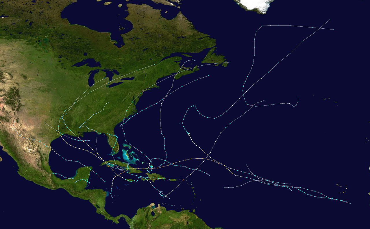
English: This map shows the tracks of all tropical cyclones in the 2008 Atlantic hurricane season. The points show the location of each storm at 6-hour intervals. The colour represents the storm's maximum sustained wind speeds as classified in the Saffir-Simpson Hurricane Scale (see below), and the shape of the data points represent the type of the storm.
Tropical depression (≤38 mph, ≤62 km/h)
Tropical storm (39–73 mph, 63–118 km/h)
Category 1 (74–95 mph, 119–153 km/h)
Category 2 (96–110 mph, 154–177 km/h)
Category 3 (111–129 mph, 178–208 km/h)
Category 4 (130–156 mph, 209–251 km/h)
Category 5 (≥157 mph, ≥252 km/h)
Unknown
Storm type |
| Source | Created using Wikipedia:WikiProject Tropical cyclones/Tracks. The background image is from NASA [1]. The tracking data is from the National Hurricane Center's Atlantic hurricane database |
| Auteur | Potapych |

|
Ce fichier peut être mis à jour pour contenir de nouvelles informations. Si vous voulez utiliser une version spécifique de ce fichier sans que les mises à jour ne s’affichent, merci d’importer la version en question dans un fichier séparé. |
| Cette œuvre a été placée dans le domaine public par son auteur, Potapych. Ceci s’applique dans le monde entier. Dans certains pays, ceci peut ne pas être possible ; dans ce cas : Potapych accorde à toute personne le droit d’utiliser cette œuvre dans n’importe quel but, sans aucune condition, sauf celles requises par la loi. |
Historique du fichier
Cliquer sur une date et heure pour voir le fichier tel qu'il était à ce moment-là.
| Date et heure | Vignette | Dimensions | Utilisateur | Commentaire | |
|---|---|---|---|---|---|
| actuel | 10 février 2009 à 01:48 | | 3 000 × 1 854 (607 kio) | Potapych (d | contributions) | {{Information |Description={{en|1=hurricane season map}} |Source=Own work by uploader |Author=Potapych |Date= |Permission= |other_versions= }} <!--{{ImageUpload|full}}--> |
Vous ne pouvez pas remplacer ce fichier.
Utilisations locales du fichier
Aucune page n’utilise ce fichier.
Utilisations du fichier sur d’autres wikis
Les autres wikis suivants utilisent ce fichier :
- Utilisation sur fr.wikipedia.org