File:2011 Battle of Sirte.svg
Aller à la navigation
Aller à la recherche

Taille de cet aperçu PNG pour ce fichier SVG : 800 × 582 pixels. Autres résolutions : 320 × 233 pixels | 640 × 465 pixels | 1 024 × 745 pixels | 1 280 × 931 pixels | 2 560 × 1 862 pixels | 821 × 597 pixels.
Fichier d’origine (Fichier SVG, nominalement de 821 × 597 pixels, taille : 56 kio)
Légendes
Légendes
Ajoutez en une ligne la description de ce que représente ce fichier
Description[modifier]
| Description |
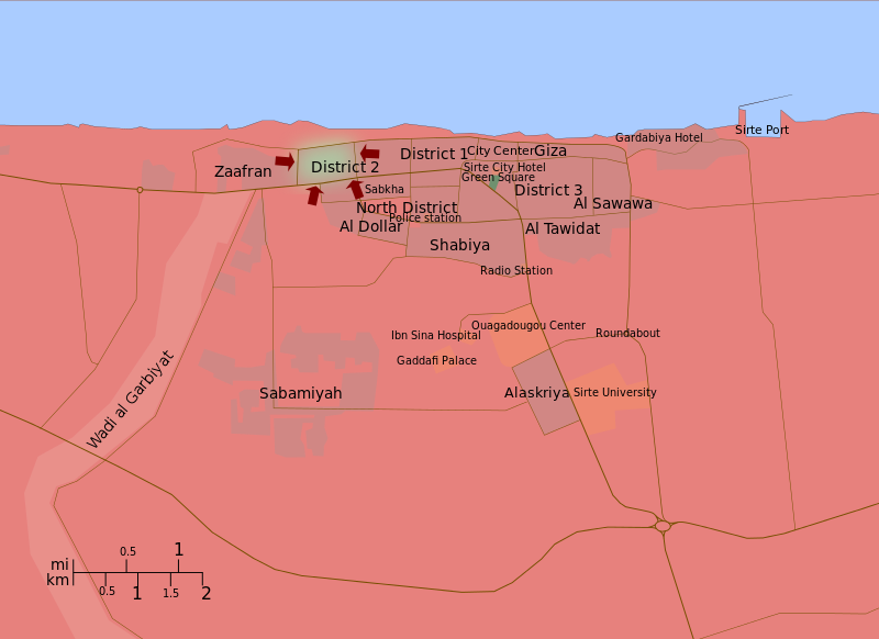
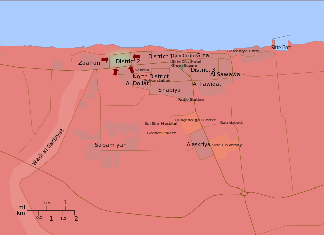
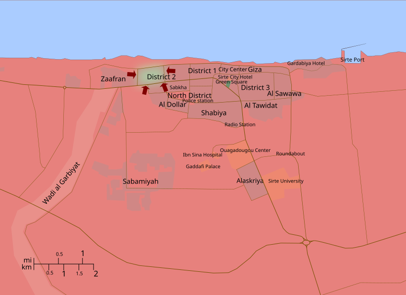
English: A map of the 2011 Battle of Sirte, showing troop movements. In green, Gaddafi Loyalists, in red, Libyan Rebels. Sources: Google Maps and Wikimapia (for the geography of the city), Reuters, Al Jazeera, etc. (for troop movements) |
| Date | |
| Source | Travail personnel |
| Auteur | Ave César Filito |
| Autres versions |
[] English: Maps of the whole country by language
English: Maps of a single area of the country
English: Historical maps
|


.svg)
.svg)

.svg)
.svg)
.svg)
.svg)
.png)


Conditions d’utilisation[modifier]
Moi, en tant que détenteur des droits d’auteur sur cette œuvre, je la publie sous la licence suivante :
| Ce fichier est disponible selon les termes de la licence Creative Commons CC0 Don universel au domaine public. | |
| La personne qui a associé une œuvre avec cet acte l’a placée dans le domaine public en renonçant mondialement à tous ses droits sur cette œuvre en vertu des lois relatives au droit d’auteur, ainsi qu’à tous les droits juridiques connexes et voisins qu’elle possédait sur l’œuvre, sans autre limite que celles imposées par la loi. Vous pouvez copier, modifier, distribuer et utiliser cette œuvre, y compris à des fins commerciales, sans qu’il soit nécessaire d’en demander la permission.
|
| Annotations | Cette image est annotée : Voir les annotations sur Wikimedia Commons |
Historique du fichier
Cliquer sur une date et heure pour voir le fichier tel qu'il était à ce moment-là.
| Date et heure | Vignette | Dimensions | Utilisateur | Commentaire | |
|---|---|---|---|---|---|
| actuel | 19 octobre 2011 à 21:06 | | 821 × 597 (56 kio) | Spesh531 (d | contributions) | Update, down to District 2 |
| 19 octobre 2011 à 21:04 |  | 821 × 597 (56 kio) | Spesh531 (d | contributions) | Update, down to District 2 | |
| 15 octobre 2011 à 13:46 |  | 821 × 597 (53 kio) | Ave César Filito (d | contributions) | updating | |
| 13 octobre 2011 à 02:02 |  | 821 × 597 (53 kio) | Spesh531 (d | contributions) | position fixes | |
| 13 octobre 2011 à 01:46 |  | 821 × 597 (53 kio) | Spesh531 (d | contributions) | fixed spellings, updated names, switched the red and green so green is on top of red, and changes areas of control according to the interactive map on the Guardian website (on the talk page). Removed outline for green | |
| 12 octobre 2011 à 20:37 |  | 821 × 597 (52 kio) | Spesh531 (d | contributions) | should be correct now | |
| 12 octobre 2011 à 20:33 |  | 821 × 597 (57 kio) | Spesh531 (d | contributions) | minor fixes | |
| 12 octobre 2011 à 20:26 |  | 821 × 597 (57 kio) | Spesh531 (d | contributions) | Fix/update scale and update in area controled in sync to Battle of Sirte (2011) | |
| 12 octobre 2011 à 16:24 |  | 821 × 597 (52 kio) | Ave César Filito (d | contributions) | updating | |
| 10 octobre 2011 à 22:28 |  | 821 × 597 (52 kio) | Ave César Filito (d | contributions) | updating |
Vous ne pouvez pas remplacer ce fichier.
Utilisations locales du fichier
Les 53 pages suivantes utilisent ce fichier :
- File:2011 Battle of Sirte.svg
- File:2011 Libya Protests Cities.png
- File:2011 Libyan Civil War.png
- File:20 March Libya Map.jpg
- File:Battle for Misrata.svg
- File:Battle of Misrata-es.svg
- File:Battle of Tripoli.svg
- File:Districts of Libya Controlled by Gaddafi and the NTC.png
- File:Front tripolitain.svg
- File:Golfe de Syrte 2011.svg
- File:Golfo de Sidra.svg
- File:Gulf of Sirt Front-es.svg
- File:Gulf of Sirt Front.svg
- File:Libyan Uprising(2011-03-06).svg
- File:Libyan Uprising(2011-03-08).svg
- File:Libyan Uprising-ar.svg
- File:Libyan Uprising-de.svg
- File:Libyan Uprising-es.svg
- File:Libyan Uprising-fa.svg
- File:Libyan Uprising-fr(2011-03-11).svg
- File:Libyan Uprising-fr(2011-03-18).svg
- File:Libyan Uprising-fr(2011-03-19).svg
- File:Libyan Uprising-fr(2011-03-20).svg
- File:Libyan Uprising-fr.svg
- File:Libyan Uprising-it.svg
- File:Libyan Uprising-mk.svg
- File:Libyan Uprising-ru(2011-03-12).png
- File:Libyan Uprising-ru.svg
- File:Libyan Uprising-sr.svg
- File:Libyan Uprising-tr.svg
- File:Libyan Uprising-zh-cn.svg
- File:Libyan Uprising.svg
- File:Libyan Uprising - Gulf of Sidra.svg
- File:Libyan Uprising Gulf of Sidra.png
- File:Libyan war final-ar.svg
- File:Libyan war final-es.svg
- File:Libyan war final-fr.svg
- File:Libyan war final.svg
- File:Libyan war final zh.svg
- File:Libyscher Bürgerkrieg.svg
- File:Mapa de la Guerra Civil Libia.PNG
- File:Mapa de la Guerra Civil Libia.gif
- File:Sirt Front-ar.svg
- File:Sirt Front-final-ar.svg
- File:Sirt Front-final.svg
- File:Tripoli uprising.svg
- File:Tripolitanian Front-ar.svg
- File:Tripolitanian Front-es.svg
- File:Tripolitanian Front-final-ar.svg
- File:Tripolitanian Front-final-es.svg
- File:Tripolitanian Front-final.svg
- File:Tripolitanian Front.svg
- Template:Other versions/Libyan Uprising
Utilisations du fichier sur d’autres wikis
Les autres wikis suivants utilisent ce fichier :
- Utilisation sur ar.wikipedia.org
- Utilisation sur ast.wikipedia.org
- Utilisation sur be.wikipedia.org
- Utilisation sur ca.wikipedia.org
- Utilisation sur ckb.wikipedia.org
- Utilisation sur en.wikipedia.org
- Utilisation sur es.wikipedia.org
- Utilisation sur fi.wikipedia.org
- Utilisation sur fr.wikipedia.org
- Utilisation sur hy.wikipedia.org
- Utilisation sur ko.wikipedia.org
- Utilisation sur pl.wikipedia.org
- Utilisation sur pt.wikipedia.org
- Utilisation sur ru.wikipedia.org
- Utilisation sur ru.wikinews.org
- Utilisation sur tr.wikipedia.org
- Utilisation sur uk.wikipedia.org
- Utilisation sur www.wikidata.org
- Utilisation sur zh.wikipedia.org