File:2011 flooding in Ayutthaya Province-EO-1 merged.jpg
原始檔案 (5,860 × 4,000 像素,檔案大小:8.4 MB,MIME 類型:image/jpeg)
說明
說明
摘要
[編輯]
| 描述 |
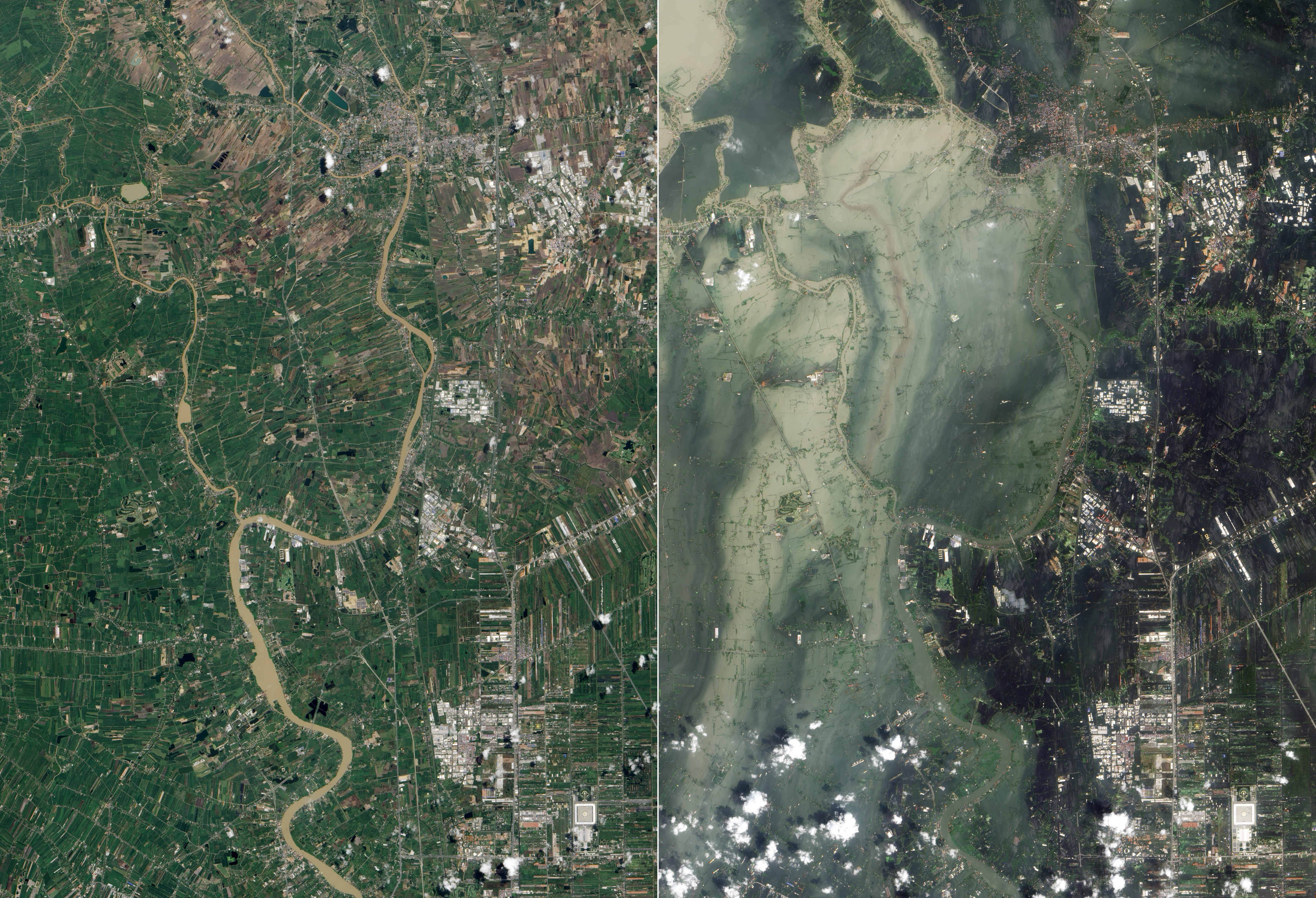
English: True-colour satellite image showing flooding in Ayutthaya and Pathum Thani Provinces in Central Thailand (right), compared to before the flooding (left).
Original caption: The Chao Phraya River forms at the confluence of smaller rivers in central Thailand, and flows southward to the Gulf of Thailand. En route to the sea, the river passes through Ayutthaya. First established in the fourteenth century, Ayutthaya lies north of Thailand’s capital city of Bangkok, and the floods plaguing Thailand in October 2011 did not spare this historic city. The Advanced Land Imager (ALI) on NASA’s Earth Observing-1 (EO-1) satellite acquired these natural-color images of Ayutthaya on October 23, 2011 ([right]), and July 11, 2011 (bottom). In both images, the Chao Phraya River curves through the southwestern part of the city (image lower left). In October, however, the river has overflowed onto nearby floodplains, especially southwest of the river and west of Route 356. Fields, roads, and buildings have all been submerged by sediment-clogged flood water. Thailand’s monsoon generally lasts from mid-May to September. Because these images show the region at different times of year, some of the differences in water and vegetation could result from normal seasonal variations. However, the large expanse of flood water in October 2011 is unusual even in a monsoon season. Flooding forced the closure of manufacturing plants in Ayutthaya, according to news reports. The city is a United Nations Educational, Scientific and Cultural Organization (UNESCO) World Heritage site. On October 12, UNESCO Bangkok announced a planned assessment of flood damage to Ayutthaya, requested by the government of Thailand. |
| 日期 | |
| 來源 | Nasa Earth Observatory |
| 作者 | NASA Earth Observatory image created by Jesse Allen and Robert Simmon, using EO-1 ALI data provided courtesy of the NASA EO-1 team and the United States Geological Survey. |
| 其他版本 |
| 拍攝地點 | | 位於此地的本圖片與其他圖片: OpenStreetMap |
|---|
|
授權條款
[編輯]
| 本作品由NASA創作,屬於公有領域。根據NASA的版權政策:“NASA的創作除非另有聲明否則不受版權保護。”(參見:Template:PD-USGov/zh,NASA版權政策或JPL圖像使用政策) | ||
 |
警告:
|
檔案歷史
點選日期/時間以檢視該時間的檔案版本。
| 日期/時間 | 縮圖 | 尺寸 | 用戶 | 備註 | |
|---|---|---|---|---|---|
| 目前 | 2011年11月11日 (五) 06:53 | | 5,860 × 4,000(8.4 MB) | Paul 012(對話 | 貢獻) | =={{int:filedesc}}== {{Information |description={{en|1=True-colour satellite image showing flooding in Ayutthaya and Pathum Thani Provinces in Central Thailand (right), compared to before the flooding (left). Original caption: The Chao Phraya River forms |
無法覆蓋此檔案。
檔案用途
沒有使用此檔案的頁面。
全域檔案使用狀況
以下其他 wiki 使用了這個檔案:
- de.wikipedia.org 的使用狀況
- en.wikipedia.org 的使用狀況
- Wikipedia:WikiProject Thailand
- Wikipedia:Featured pictures/Natural phenomena/Weather
- Conservation photography
- Wikipedia:WikiProject Thailand/Recognized content
- User talk:Paul 012/Archive 4
- Wikipedia:Featured pictures thumbs/29
- 2011 Thailand floods
- Talk:2011 Thailand floods
- Wikipedia:Featured picture candidates/November-2011
- Wikipedia:Featured picture candidates/2011 flooding in Ayutthaya, Thailand
- Wikipedia:Wikipedia Signpost/2011-11-28/Featured content
- User talk:Paul 012/Archive 5
- Wikipedia:Picture of the day/March 2013
- Template:POTD/2013-03-20
- Wikipedia:Main Page history/2013 March 20
- Wikipedia:Wikipedia Signpost/Single/2011-11-28
- fr.wikipedia.org 的使用狀況
- ms.wikipedia.org 的使用狀況
- uz.wikipedia.org 的使用狀況
- zh.wikipedia.org 的使用狀況