File:2013 Woolwich attack map.PNG
Ir a la navegación
Ir a la búsqueda
No disponible a mayor resolución.
2013_Woolwich_attack_map.PNG (709 × 556 píxeles; tamaño de archivo: 112 kB; tipo MIME: image/png)
Leyendas
Leyendas
Añade una explicación corta acerca de lo que representa este archivo
Resumen[editar]
| Descripción |
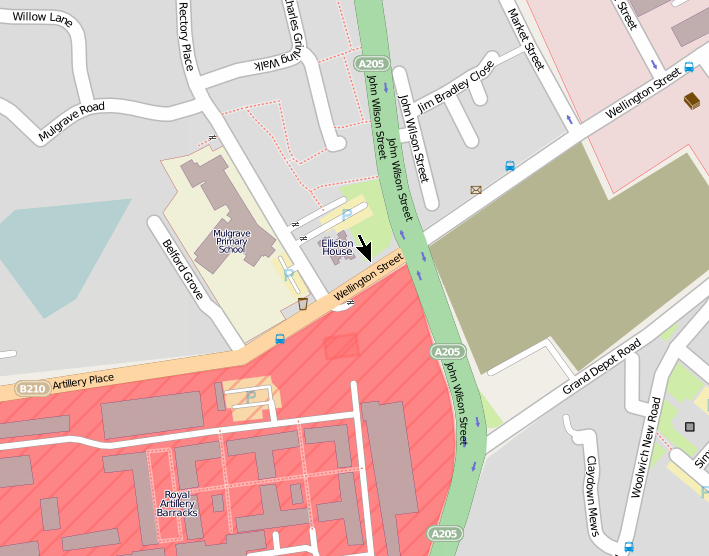
 The tower block on the right is Elliston House. English: Location of 2013 Woolwich attack, created using OpenStreetMap data The location of the incident is marked with an arrow in the centre. Elliston House is a tower block. The incident took place in Wellington Street near the junction with John Wilson Street. The site of the attack is on the perimeter of the Royal Artillery Barracks.The image on the right shows Elliston House, and the road sign into which the car crashed during the attack. Map co-ordinates: 51°29′19″N 0°03′45″E / 51.4885°N 0.06255°E Google Street View is here. |
| Fecha | |
| Fuente | Trabajo propio |
| Autor | Ianmacm |
Licencia[editar]
| This work contains information from OpenStreetMap, which is made available under the Open Database License (ODbL).
The ODbL does not require any particular license for maps produced from ODbL data. Prior to 1 August 2020, map tiles produced by the OpenStreetMap Foundation were licensed under the CC-BY-SA-2.0 license. Maps produced by other people may be subject to other licences. |
Este archivo se encuentra bajo la licencia Creative Commons Genérica de Atribución/Compartir-Igual 3.0.
- Eres libre:
- de compartir – de copiar, distribuir y transmitir el trabajo
- de remezclar – de adaptar el trabajo
- Bajo las siguientes condiciones:
- atribución – Debes otorgar el crédito correspondiente, proporcionar un enlace a la licencia e indicar si realizaste algún cambio. Puedes hacerlo de cualquier manera razonable pero no de manera que sugiera que el licenciante te respalda a ti o al uso que hagas del trabajo.
- compartir igual – En caso de mezclar, transformar o modificar este trabajo, deberás distribuir el trabajo resultante bajo la misma licencia o una compatible como el original.
Historial del archivo
Haz clic sobre una fecha y hora para ver el archivo tal como apareció en ese momento.
| Fecha y hora | Miniatura | Dimensiones | Usuario | Comentario | |
|---|---|---|---|---|---|
| actual | 05:50 26 may 2013 | | 709 × 556 (112 kB) | Ianmacm (discusión | contribs.) | place scene of incident and arrow at centre of image, per talk page request |
| 17:44 25 may 2013 |  | 684 × 566 (84 kB) | Ianmacm (discusión | contribs.) | larger arrow per talk page request | |
| 07:35 25 may 2013 |  | 684 × 566 (83 kB) | Ianmacm (discusión | contribs.) | with arrow marking location of the incident, per talk page request | |
| 17:52 23 may 2013 |  | 686 × 568 (107 kB) | Ianmacm (discusión | contribs.) | better crop, try again, did not seem to upload correctly the last time | |
| 17:42 23 may 2013 |  | 686 × 568 (107 kB) | Ianmacm (discusión | contribs.) | better crop | |
| 14:05 23 may 2013 |  | 702 × 472 (95 kB) | Ianmacm (discusión | contribs.) | User created page with UploadWizard |
No puedes sobrescribir este archivo.
Usos del archivo
No hay páginas que enlacen a este archivo.
Uso global del archivo
Las wikis siguientes utilizan este archivo:
- Uso en de.wikipedia.org
- Uso en es.wikipedia.org
- Uso en incubator.wikimedia.org
- Uso en it.wikinews.org
- Uso en zh-yue.wikipedia.org
- Uso en zh.wikipedia.org