File:2016 Fukushima earthquake intensity map.jpg
跳至導覽
跳至搜尋
預覽大小:473 × 600 像素。 其他解析度:189 × 240 像素 | 378 × 480 像素 | 787 × 998 像素。
原始檔案 (787 × 998 像素,檔案大小:251 KB,MIME 類型:image/jpeg)
說明
說明
添加單行說明來描述出檔案所代表的內容
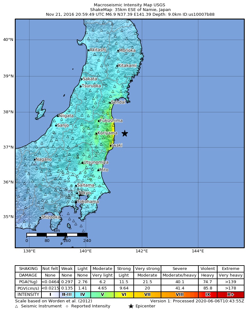
Shakemap for the 2016 Fukushima earthquake
摘要
[編輯]
| 描述 |
English: USGS ShakeMap for the 2016 Fukushima earthquake |
| 日期 | |
| 來源 | https://earthquake.usgs.gov/earthquakes/eventpage/us10007b88/ |
| 作者 | 美國地質調查局 |
授權條款
[編輯]
此檔案採用共享創意 姓名標示-相同方式分享 4.0 國際授權條款。
- 您可以自由:
- 分享 – 複製、發佈和傳播本作品
- 重新修改 – 創作演繹作品
- 惟需遵照下列條件:
- 姓名標示 – 您必須指名出正確的製作者,和提供授權條款的連結,以及表示是否有對內容上做出變更。您可以用任何合理的方式來行動,但不得以任何方式表明授權條款是對您許可或是由您所使用。
- 相同方式分享 – 如果您利用本素材進行再混合、轉換或創作,您必須基於如同原先的相同或兼容的條款,來分布您的貢獻成品。
檔案歷史
點選日期/時間以檢視該時間的檔案版本。
| 日期/時間 | 縮圖 | 尺寸 | 用戶 | 備註 | |
|---|---|---|---|---|---|
| 目前 | 2022年3月20日 (日) 06:27 | | 787 × 998(251 KB) | Fukushima86(對話 | 貢獻) | Uploaded a work by United States Geological Survey from https://earthquake.usgs.gov/earthquakes/eventpage/us10007b88/ with UploadWizard |
無法覆蓋此檔案。
檔案用途
沒有使用此檔案的頁面。
全域檔案使用狀況
以下其他 wiki 使用了這個檔案:
- ca.wikipedia.org 的使用狀況
- es.wikipedia.org 的使用狀況
- ko.wikipedia.org 的使用狀況
- uk.wikipedia.org 的使用狀況
- www.wikidata.org 的使用狀況
- zh.wikipedia.org 的使用狀況