File:2023-03-01 Holarua 2.jpg
Zur Navigation springen
Zur Suche springen

Größe dieser Vorschau: 800 × 526 Pixel. Weitere Auflösungen: 320 × 210 Pixel | 640 × 421 Pixel | 993 × 653 Pixel.
Originaldatei (993 × 653 Pixel, Dateigröße: 430 KB, MIME-Typ: image/jpeg)
Bildtexte
Kurzbeschreibungen
Ergänze eine einzeilige Erklärung, was diese Datei darstellt.
Beschreibung
[Bearbeiten]
| Beschreibung |
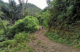
Tetun: Aktividade MOP-IGEADI halao hela levantamento de dadus kona ba Melhoramento Estrada Rural (Item: Unsuitable Excavation/Cut to spoilt hard soil, Subgrade Preparation, & Back Fill) ho Distancia KM 5 Diresaun Aldeia Datina (Estrada Nacional) liga ba Aldeia Leobrema, Anelumo, Deonae, & Blaro iha Suco Holarua, Postu Administrativo Same, Municipio Manu-Fahi.
|
| Datum | |
| Quelle | IGEADI Timor Leste |
| Urheber | Matabu u Belo, IGEADI Timor Leste |
Lizenz
[Bearbeiten]
This file is in the public domain in East Timor, because it is published and distributed by the Government of Democratic Republic of Timor-Leste, according to Article 13 of the Indonesia Copyright Law No 6, 1982, which was still valid in East Timor from independence on 20 May 2002 until 27 May 2023.[1]
There shall be no infringement of Copyright for:
|
 |
Dateiversionen
Klicke auf einen Zeitpunkt, um diese Version zu laden.
| Version vom | Vorschaubild | Maße | Benutzer | Kommentar | |
|---|---|---|---|---|---|
| aktuell | 20:48, 7. Mär. 2023 | | 993 × 653 (430 KB) | J. Patrick Fischer (Diskussion | Beiträge) | {{Information |description={{tet|1=Aktividade MOP-IGEADI halao hela levantamento de dadus kona ba Melhoramento Estrada Rural (Item: Unsuitable Excavation/Cut to spoilt hard soil, Subgrade Preparation, & Back Fill) ho Distancia KM 5 Diresaun Aldeia Datina (Estrada Nacional) liga ba Aldeia Leobrema, Anelumo, Deonae, & Blaro iha Suco Holarua, Postu Administrativo Same, Municipio Manu-Fahi. # media IGEADI}} |date=2023-03-01 |source=[https://www.facebook.com/IGETL/posts/pfbid02qbPUBBtr68NYuhK7cFKN... |
Du kannst diese Datei nicht überschreiben.
Dateiverwendung
Keine Seiten verwenden diese Datei.
Globale Dateiverwendung
Die nachfolgenden anderen Wikis verwenden diese Datei:
- Verwendung auf de.wikipedia.org